National Register of Historic Places listings in Yosemite National Park
This is a list of the National Register of Historic Places listings in Yosemite National Park.
This is intended to be a complete list of the properties and districts on the National Register of Historic Places in Yosemite National Park, California, United States. The locations of National Register properties and districts for which the latitude and longitude coordinates are included below, may be seen in a Google map.[1]
There are 30 properties and districts listed on the National Register in the park and five National Historic Landmarks. Four more properties associated with the park are located just outside the park boundaries.
- This National Park Service list is complete through NPS recent listings posted December 16, 2016.[2]
Current listings


Associated properties
The following properties are on property owned by the National Park Service and administered by Yosemite National Park, but are not within the park proper:
| Landmark name | Image | Date listed | Location | City or Town | Summary | |
|---|---|---|---|---|---|---|
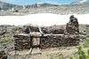
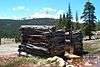
| 1 | Bagby Stationhouse, Water Tanks and Turntable | 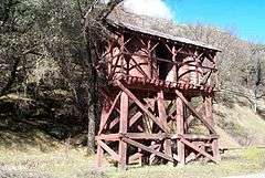 |
April 13, 1979 | CA 140 37°40′27″N 119°46′47″W / 37.67417°N 119.77972°W |
El Portal | |
| 2 | Hetch Hetchy Railroad Engine No.6 | 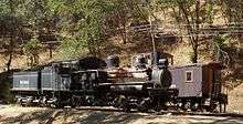 |
January 30, 1978 | CA 140 37°40′30″N 119°46′46″W / 37.67500°N 119.77944°W |
El Portal | Shay railroad engine used to build O'Shaughnessy Dam. On Park Service property just outside the park proper. |
| 3 | Track Bus No. 19 | May 22, 1978 | CA 140 37°40′30″N 119°46′46″W / 37.67500°N 119.77944°W |
El Portal | ||
| 4 | Yosemite Valley Railroad Caboose No. 15 | May 22, 1978 | CA 140 37°40′30″N 119°46′46″W / 37.67500°N 119.77944°W |
El Portal |
See also
- National Register of Historic Places listings in Mariposa County, California
- National Register of Historic Places listings in Tuolumne County, California
- National Register of Historic Places listings in California
References
- ↑ The latitude and longitude information provided in this table was derived originally from the National Register Information System, which has been found to be fairly accurate for about 99% of listings. For about 1% of NRIS original coordinates, experience has shown that one or both coordinates are typos or otherwise extremely far off; some corrections may have been made. A more subtle problem causes many locations to be off by up to 150 yards, depending on location in the country: most NRIS coordinates were derived from tracing out latitude and longitudes off of USGS topographical quadrant maps created under the North American Datum of 1927, which differs from the current, highly accurate WGS84 GPS system used by most on-line maps. Chicago is about right, but NRIS longitudes in Washington are higher by about 4.5 seconds, and are lower by about 2.0 seconds in Maine. Latitudes differ by about 1.0 second in Florida. Some locations in this table may have been corrected to current GPS standards.
- ↑ "National Register of Historic Places: Weekly List Actions". National Park Service, United States Department of the Interior. Retrieved on December 16, 2016.
- ↑ Numbers represent an ordering by significant words. Various colorings, defined here, differentiate National Historic Landmark sites and National Register of Historic Places Districts from other NRHP buildings, structures, sites or objects.
- ↑ National Park Service (2008-04-24). "National Register Information System". National Register of Historic Places. National Park Service.
External links
| Wikimedia Commons has media related to Structures in Yosemite National Park. |
| Attractions |
| |||||||
|---|---|---|---|---|---|---|---|---|
| People | ||||||||
| Lodging & camping | ||||||||
| Natural disasters | ||||||||
| Transportation | ||||||||
| Nearby municipalities | ||||||||
| Additional information |
| |||||||

| Topics | |
|---|---|
| Lists by states |
|
| Lists by insular areas | |
| Lists by associated states | |
| Other areas | |
| |