Nagcarlan, Laguna
| Nagcarlan | ||
|---|---|---|
| Municipality | ||
 | ||
| ||
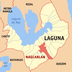 Map of Laguna showing the location of Nagcarlan | ||
.svg.png) Nagcarlan Location within the Philippines | ||
| Coordinates: 14°08′N 121°25′E / 14.133°N 121.417°ECoordinates: 14°08′N 121°25′E / 14.133°N 121.417°E | ||
| Country | Philippines | |
| Region | CALABARZON (Region IV-A) | |
| Province | Laguna | |
| District | 3rd District of Laguna | |
| Founded | 1583 | |
| Barangays | 52 | |
| Government[1] | ||
| • Mayor | Nelson M. Osuna | |
| Area[2] | ||
| • Total | 78.10 km2 (30.15 sq mi) | |
| Elevation | 229.0 m (751.3 ft) | |
| Population (2010)[3] | ||
| • Total | 59,726 | |
| • Density | 760/km2 (2,000/sq mi) | |
| Demonym(s) | Nagcarlangin | |
| Time zone | PST (UTC+8) | |
| ZIP code | 4002 | |
| Dialing code | 49 | |
| Income class | 2nd | |

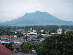
Nagcarlan is a second class municipality in the province of Laguna, Philippines. According to the 2010 census, it has a population of 59,726 people.[3] It is 16 kilometres (9.9 mi) northeast of San Pablo City, or 103 kilometres (64 mi) south of Manila. Its coordinates are N14°07.93' E121°24.93' at 229.0 meters above sealevel.
Tourism in Nagcarlan
Nagcarlan has clean flowing rivers, gushing water falls, calm lakes and lush hills and mountains. Historic Spanish colonial sites, restaurants with competitive and affordable dishes, resorts and vacation house and a plethora of welcoming people.
Lack of promotion has caused this town to be overlooked by tourist and that is why locals have made their own ways to promote this town through blogging websites and conducting nature oriented activities like hiking and running.
Barangays
Nagcarlan is subdivided into 52 barangays.[2]
- Abo
- Alibungbungan
- Alumbrado
- Balayong
- Balimbing
- Balinacon
- Bambang
- Banago
- Banca-banca
- Bangcuro
- Banilad
- Bayaquitos
- Buboy
- Buenavista
- Buhanginan
- Bukal
- Bunga
- Cabuyew
- Calumpang
- Kanluran Lazaan
- Silangan Lazaan
- Labangan
- Lawaguin
- Kanluran Lazaan
- Silangan Lazaan
- Lagulo
- Maiit
- Malaya
- Malinao
- Manaol
- Maravilla
- Nagcalbang
- Poblacion I (Pob.)
- Poblacion II (Pob.)
- Poblacion III (Pob.)
- Oples
- Palayan
- Palina
- Sabang
- San Francisco
- Sibulan
- Silangan Napapatid
- Silangan Ilaya
- Sinipian
- Santa Lucia
- Sulsuguin
- Talahib
- Talangan
- Taytay
- Tipacan
- Wakat
- Yukos
Demographics
| Population census of Nagcarlan | ||
|---|---|---|
| Year | Pop. | ±% p.a. |
| 1990 | 37,696 | — |
| 1995 | 43,679 | +2.80% |
| 2000 | 48,727 | +2.37% |
| 2007 | 57,070 | +2.20% |
| 2010 | 59,726 | +1.67% |
| Source: National Statistics Office[3] | ||
References
- ↑ "Official City/Municipal 2013 Election Results". Intramuros, Manila, Philippines: Commission on Elections (COMELEC). 11 September 2013. Retrieved 20 November 2013.
- 1 2 "Province: LAGUNA". PSGC Interactive. Makati City, Philippines: National Statistical Coordination Board. Retrieved 20 November 2013.
- 1 2 3 "Total Population by Province, City, Municipality and Barangay: as of May 1, 2010" (PDF). 2010 Census of Population and Housing. National Statistics Office. Retrieved 20 November 2013.
External links
| Wikimedia Commons has media related to Nagcarlan, Laguna. |
- BYAHILO: Nagcarlan Underground Cemetery
- Philippine Standard Geographic Code
- Philippine Census Information
- Local Governance Performance Management System
 |
Victoria | Pila | Magdalena | |
| Calauan San Pablo |
|
Liliw | ||
| ||||
| | ||||
| Rizal | Dolores, Quezon / Candelaria, Quezon |
Santa Cruz (capital) | |
| Municipalities | |
| Component Cities | |
| Barangays | |
