Calaca, Batangas
| Calaca | ||
|---|---|---|
| Municipality | ||
 | ||
| ||
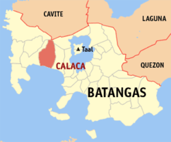 Location within Batangas province | ||
.svg.png) Calaca Location within the Philippines | ||
| Coordinates: 13°58′N 120°48′E / 13.97°N 120.8°ECoordinates: 13°58′N 120°48′E / 13.97°N 120.8°E | ||
| Country | Philippines | |
| Region | Calabarzon (Region IV-A) | |
| Province | Batangas | |
| District | 1st District | |
| Founded | 1835 | |
| Barangays | 40 (see Barangays) | |
| Government [1] | ||
| • Type | Sangguniang Bayan | |
| • Mayor | Sofronio Manuel C. Ona | |
| Area[2] | ||
| • Total | 114.58 km2 (44.24 sq mi) | |
| Population (2015 census)[3] | ||
| • Total | 81,859 | |
| • Density | 710/km2 (1,900/sq mi) | |
| • Voter (2016)[4] | 44,883 | |
| Time zone | PST (UTC+8) | |
| ZIP code | 4212 | |
| IDD : area code | +63 (0)43 | |
| Income class | 1st class | |
| PSGC | 041007000 | |
| Website |
calaca | |

Calaca, officially the Municipality of Calaca (Filipino: Bayan ng Calaca), is a municipality in the province of Batangas in the Calabarzon (Region IV-A) of the Philippines. The population was 81,859 at the 2015 census.[3] In the 2016 election, it had 44,883 registered voters.[4]
Calaca is home to the lively Calacatchara festival (a portmanteau of Calaca and atchara (chutney) named after the famous Philippine dish Atchara (chutney) (made from papaya).
Geography
Calaca is located at 13°58′N 120°48′E / 13.97°N 120.8°E.
According to the Philippine Statistics Authority, the municipality has a land area of 114.58 square kilometres (44.24 sq mi)[2] constituting 3.67% of the 3,119.75-square-kilometre- (1,204.54 sq mi) total area of Batangas.
Barangays
Calaca is politically subdivided into 40 barangays.[5]
| PSGC | Barangay | Population | ±% p.a. | ||
|---|---|---|---|---|---|
| 2015[3] | 2010[6] | ||||
| 041007001 | Bagong Tubig | 3.0% | 2,434 | 2,083 | +3.01% |
| 041007002 | Baclas | 2.1% | 1,688 | 1,574 | +1.34% |
| 041007003 | Balimbing | 0.6% | 494 | 456 | +1.54% |
| 041007004 | Bambang | 1.7% | 1,415 | 1,239 | +2.56% |
| 041007006 | Barangay 1 (Poblacion) | 2.3% | 1,903 | 1,839 | +0.65% |
| 041007007 | Barangay 2 (Poblacion) | 1.0% | 827 | 729 | +2.43% |
| 041007008 | Barangay 3 (Poblacion) | 0.3% | 278 | 279 | −0.07% |
| 041007009 | Barangay 4 (Poblacion) | 1.3% | 1,031 | 908 | +2.45% |
| 041007010 | Barangay 5 (Poblacion) | 1.3% | 1,096 | 1,004 | +1.68% |
| 041007011 | Barangay 6 (Poblacion) | 0.9% | 762 | 742 | +0.51% |
| 041007012 | Bisaya | 1.2% | 1,016 | 861 | +3.20% |
| 041007013 | Cahil | 4.6% | 3,742 | 2,929 | +4.77% |
| 041007014 | Caluangan | 2.3% | 1,863 | 1,699 | +1.77% |
| 041007015 | Calantas | 3.8% | 3,128 | 2,784 | +2.24% |
| 041007016 | Camastilisan | 5.1% | 4,147 | 3,425 | +3.71% |
| 041007017 | Coral ni Lopez (Sugod) | 2.3% | 1,921 | 1,695 | +2.41% |
| 041007018 | Coral ni Bacal | 1.7% | 1,389 | 1,145 | +3.75% |
| 041007019 | Dacanlao | 7.5% | 6,177 | 5,243 | +3.17% |
| 041007020 | Dila | 2.0% | 1,624 | 1,504 | +1.47% |
| 041007021 | Loma | 1.6% | 1,346 | 1,112 | +3.70% |
| 041007022 | Lumbang Calzada | 3.4% | 2,820 | 2,329 | +3.71% |
| 041007023 | Lumbang na Bata | 2.3% | 1,873 | 1,769 | +1.09% |
| 041007024 | Lumbang na Matanda | 3.1% | 2,549 | 1,944 | +5.29% |
| 041007025 | Madalunot | 2.4% | 1,927 | 1,675 | +2.70% |
| 041007027 | Makina | 1.6% | 1,301 | 1,094 | +3.35% |
| 041007028 | Matipok | 2.2% | 1,830 | 1,515 | +3.66% |
| 041007030 | Munting Coral | 0.5% | 387 | 328 | +3.20% |
| 041007031 | Niyugan | 1.7% | 1,404 | 1,185 | +3.28% |
| 041007032 | Pantay | 6.9% | 5,654 | 4,517 | +4.37% |
| 041007033 | Puting Bato West | 4.0% | 3,291 | 2,892 | +2.49% |
| 041007034 | Puting Kahoy | 1.6% | 1,310 | 1,179 | +2.03% |
| 041007035 | Puting Bato East | 2.6% | 2,145 | 2,001 | +1.33% |
| 041007036 | Quisumbing | 2.7% | 2,193 | 1,824 | +3.57% |
| 041007037 | Salong | 5.8% | 4,766 | 4,130 | +2.76% |
| 041007038 | San Rafael | 1.2% | 965 | 661 | +7.47% |
| 041007039 | Sinisian | 2.5% | 2,025 | 1,764 | +2.66% |
| 041007041 | Taklang Anak | 1.5% | 1,190 | 980 | +3.77% |
| 041007042 | Talisay | 2.4% | 1,985 | 1,935 | +0.49% |
| 041007043 | Tamayo | 1.9% | 1,590 | 1,435 | +1.97% |
| 041007044 | Timbain | 2.9% | 2,373 | 2,114 | +2.22% |
| Total | 81,859 | 70,521 | +2.88% | ||
Demographics
| Population census of Calaca | |||||||||||||||||||||||||
|---|---|---|---|---|---|---|---|---|---|---|---|---|---|---|---|---|---|---|---|---|---|---|---|---|---|
|
| ||||||||||||||||||||||||
| Source: PSA[3][6][7] | |||||||||||||||||||||||||
In the 2015 census, Calaca had a population of 81,859.[3] The population density was 710 inhabitants per square kilometre (1,800/sq mi).
In the 2016 election, it had 44,883 registered voters.[4]
Gallery
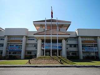 Municipal hall
 Police station
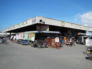 Public market
 Saint Raphael the Archangel Parish Church
References
- ↑ "Municipality". Quezon City, Philippines: Department of the Interior and Local Government. Retrieved 31 May 2013.
- 1 2 "Province: Batangas". PSGC Interactive. Makati City, Philippines: Philippine Statistics Authority. Retrieved 26 November 2016.
- 1 2 3 4 5 "Region IV-A (CALABARZON)". Census of Population (2015): Total Population by Province, City, Municipality and Barangay (Report). PSA. Retrieved 20 June 2016.
- 1 2 3 "2016 National and Local Elections Statistics". Commission on Elections. 2016.
- ↑ "Municipal: Calaca, Batangas". PSA. Philippines: National Statistical Coordination Board. Retrieved 8 January 2016.
- 1 2 "Region IV-A (CALABARZON)". Census of Population and Housing (2010): Total Population by Province, City, Municipality and Barangay (Report). NSO. Retrieved 29 June 2016.
- ↑ "Region IV-A (CALABARZON)". Census of Population (1995, 2000 and 2007): Total Population by Province, City and Municipality (Report). NSO. Archived from the original on 24 June 2011.
External links
| Wikimedia Commons has media related to Calaca, Batangas. |
 |
Nasugbu | |
Laurel | |
| Balayan | |
Lemery | ||
| ||||
| | ||||
| Balayan Bay |
Batangas (capital) | |
| Municipalities | |
| Component cities | |