Calatagan, Batangas
| Calatagan | ||
|---|---|---|
| Municipality | ||
 | ||
| ||
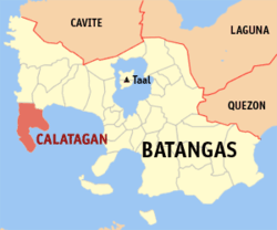 Location within Batangas province | ||
.svg.png) Calatagan Location within the Philippines | ||
| Coordinates: 13°50′N 120°38′E / 13.83°N 120.63°ECoordinates: 13°50′N 120°38′E / 13.83°N 120.63°E | ||
| Country | Philippines | |
| Region | Calabarzon (Region IV-A) | |
| Province | Batangas | |
| District | 1st District | |
| Founded | 1912 | |
| Government acquisition | October 28, 1957 | |
| Barangays | 25 (see Barangays) | |
| Government [1] | ||
| • Type | Sangguniang Bayan | |
| • Mayor | Peter Oliver Palacio (LP) | |
| • Vice Mayor | Andrea del Rosario (NP) | |
| Area[2] | ||
| • Total | 112 km2 (43 sq mi) | |
| Population (2015 census)[3] | ||
| • Total | 56,449 | |
| • Density | 500/km2 (1,300/sq mi) | |
| • Voter (2016)[4] | 31,030 | |
| Time zone | PST (UTC+8) | |
| ZIP code | 4215 | |
| IDD : area code | +63 (0)43 | |
| Income class | 2nd class | |
| PSGC | 041008000 | |
| Website |
www | |

Calatagan, officially the Municipality of Calatagan (Filipino: Bayan ng Calatagan), is a municipality in the province of Batangas in the Calabarzon (Region IV-A) of the Philippines. The population was 56,449 at the 2015 census.[3] In the 2016 election, it had 31,030 registered voters.[4]
Calatagan comprises the Calatagan Peninsula between the South China Sea and Balayan Bay. The peninsula's near white sand beaches are well-known vacation and leisure sites. There are several beach resorts including the Banak House Calatagan on Calatagan beach, the Ronco Beach Resort in barangay Bagong Silang, Playa Calatagan in barangay Santa Ana, the Golden Sunset Resort in barangay Uno, Lago de Oro Resort in barangay Balibago, Villa Agustina in barangay Bagong Silang, and Nacua Sea Park in barangay Quilitisan. Calatagan was formerly titled as the Forbes Park of the South, because of the rich families who own estates here.
An extremely rare example of pre-Spanish Philippine script was found in Calatagan. The script is called Baybayin in Tagalog, and was derived from Javanese writing, which in turn is derived from Brahmi. This writing survived on an earthenware burial jar dated to the 13th or 14th century. A Spanish lighthouse can also be found at Cape Santiago at the peninsula's southern tip dating back to the 1890s and is also one of the municipality's main tourist attractions.
History
The word "Calatagan" is taken from the Tagalog word "latag" and is closely associated with "kapatagan", which means a vast portion of flat land lying between the hills and mountains. Thus, Calatagan means a large expanse of wide flat land.[5]
The town is the site of the historically and archaeologically famous Calatagan Excavation whose antique pottery and utensils contributed important facts about the culture and activities of the Filipinos before the coming of the Spaniards. Chinese pottery, unearthed from six large cemeteries by archaeologists Olov T.R Jones and Robert B. Fox led to a conclusion made by K. Otley Bayer which points out the existence of a sizable pre-Spanish population in the town. The same studies suggested that there were direct Chinese trade by water in Calatagan and centered at a place called Balong-Bato, wherein an entrance through the reef, which surrounds Calatagan, is still presently used by vessels coming from Mindoro and Manila.
The land occupied by the municipality of Calatagan was acquired by Domingo Roxas from the Spanish Crown in 1829 and was called Hacienda de Calatagan. The successors Pedro P. Roxas and Antonio R. Roxas continued to develop it.
In 1912, through Executive Order No. 78 by then Governor General William Cameron Forbes, Calatagan became a municipality independent from its mother municipality, Balayan.
In 1931, Carmen Roxas, the last heir of the Roxas Clan transferred ownership of the Hacienda to the Zobel brothers, Jacobo and Alfonso. During the time of the Zobels, the hacienda came to be known as Central Azucarera de Calatagan or simply "Central Carmen" when referring to the sugar milling complex.
In 1934, the barangays of Baha and Talibayog which were parts of the Municipality of Balayan were annexed to Calatagan since surveys showed that they are part of the land titled to the original owner of Hacienda Calatagan. This added a big area to the municipality.
In 1957, a decade after the Philippines gained independence from the Americans, the Land Tenure Administration, upon petition of the people of Calatagan bought the Hacienda Lands from the Zobels. These were apportioned to the inhabitants and sold to them at ₱5.00 per hectare payable in installment within a period of 25 years.[5]
Geography
Calatagan is located at 13°50′N 120°38′E / 13.83°N 120.63°E.
According to the Philippine Statistics Authority, the municipality has a land area of 112 square kilometres (43 sq mi)[2] constituting 3.59% of the 3,119.75-square-kilometre- (1,204.54 sq mi) total area of Batangas.
Barangays
Calatagan is politically subdivided into 25 barangays.[6]
| PSGC | Barangay | Population | ±% p.a. | ||
|---|---|---|---|---|---|
| 2015[3] | 2010[7] | ||||
| 041008001 | Bagong Silang | 4.0% | 2,270 | 2,074 | +1.73% |
| 041008002 | Baha | 2.7% | 1,509 | 1,494 | +0.19% |
| 041008003 | Balibago | 6.0% | 3,377 | 3,161 | +1.27% |
| 041008004 | Balitoc | 5.4% | 3,023 | 2,814 | +1.37% |
| 041008005 | Biga | 5.0% | 2,849 | 2,795 | +0.37% |
| 041008006 | Bucal | 1.7% | 965 | 892 | +1.51% |
| 041008007 | Carlosa | 2.5% | 1,414 | 1,253 | +2.33% |
| 041008008 | Carretunan | 2.7% | 1,504 | 1,449 | +0.71% |
| 041008009 | Encarnacion | 2.4% | 1,327 | 1,049 | +4.58% |
| 041008010 | Gulod | 5.5% | 3,127 | 2,798 | +2.14% |
| 041008011 | Hukay | 3.8% | 2,120 | 2,124 | −0.04% |
| 041008013 | Lucsuhin | 8.0% | 4,528 | 4,299 | +0.99% |
| 041008014 | Luya | 1.2% | 664 | 616 | +1.44% |
| 041008015 | Paraiso | 2.4% | 1,346 | 1,133 | +3.33% |
| 041008016 | Barangay 1 (Poblacion) | 6.1% | 3,433 | 3,150 | +1.65% |
| 041008017 | Barangay 2 (Poblacion) | 2.5% | 1,408 | 1,296 | +1.59% |
| 041008018 | Barangay 3 (Poblacion) | 1.7% | 953 | 760 | +4.40% |
| 041008019 | Barangay 4 (Poblacion) | 5.1% | 2,863 | 2,770 | +0.63% |
| 041008020 | Quilitisan | 3.9% | 2,176 | 2,022 | +1.41% |
| 041008021 | Real | 2.8% | 1,588 | 1,380 | +2.71% |
| 041008022 | Sambungan | 3.5% | 1,975 | 1,820 | +1.57% |
| 041008023 | Santa Ana | 5.7% | 3,209 | 2,747 | +3.00% |
| 041008026 | Talibayog | 3.5% | 1,980 | 1,783 | +2.02% |
| 041008027 | Talisay | 4.6% | 2,617 | 2,524 | +0.69% |
| 041008028 | Tanagan | 7.5% | 4,224 | 3,794 | +2.07% |
| Total | 56,449 | 51,997 | +1.58% | ||
Demographics
| Population census of Calatagan | |||||||||||||||||||||||||
|---|---|---|---|---|---|---|---|---|---|---|---|---|---|---|---|---|---|---|---|---|---|---|---|---|---|
|
| ||||||||||||||||||||||||
| Source: PSA[3][7][8] | |||||||||||||||||||||||||
In the 2015 census, Calatagan had a population of 56,449.[3] The population density was 500 inhabitants per square kilometre (1,300/sq mi).
In the 2016 election, it had 31,030 registered voters.[4]
Gallery
 Municipal hall
 Downtown Calatagan
 Plaza
Plaza Saint Dominic of Silos Parish Church
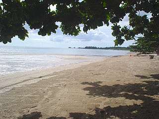 Beach in Calatagan
References
- ↑ "Municipality". Quezon City, Philippines: Department of the Interior and Local Government. Retrieved 31 May 2013.
- 1 2 "Province: Batangas". PSGC Interactive. Makati City, Philippines: Philippine Statistics Authority. Retrieved 26 November 2016.
- 1 2 3 4 5 "Region IV-A (CALABARZON)". Census of Population (2015): Total Population by Province, City, Municipality and Barangay (Report). PSA. Retrieved 20 June 2016.
- 1 2 3 "2016 National and Local Elections Statistics". Commission on Elections. 2016.
- 1 2 "Brief Description of LGU". Calatagan LGU Website. Archived from the original on 2 July 2014. Retrieved 14 June 2014.
- ↑ "Municipal: Calatagan, Batangas". PSA. Philippines: National Statistical Coordination Board. Retrieved 8 January 2016.
- 1 2 "Region IV-A (CALABARZON)". Census of Population and Housing (2010): Total Population by Province, City, Municipality and Barangay (Report). NSO. Retrieved 29 June 2016.
- ↑ "Region IV-A (CALABARZON)". Census of Population (1995, 2000 and 2007): Total Population by Province, City and Municipality (Report). NSO. Archived from the original on 24 June 2011.
External links
| Wikimedia Commons has media related to Calatagan, Batangas. |
 |
Lian | Balayan | | |
| South China Sea | |
Balayan Bay Pagapas Bay | ||
| ||||
| | ||||
| Isla Verde Passage |
Batangas (capital) | |
| Municipalities | |
| Component cities | |