Mosquero, New Mexico
| Mosquero, New Mexico | |
|---|---|
| Village | |
 | |
 Location of Mosquero, New Mexico | |
 Mosquero, New Mexico Location in the United States | |
| Coordinates: 35°46′35″N 103°57′26″W / 35.77639°N 103.95722°WCoordinates: 35°46′35″N 103°57′26″W / 35.77639°N 103.95722°W | |
| Country | United States |
| State | New Mexico |
| Counties | Harding, San Miguel |
| Area | |
| • Total | 1.0 sq mi (2.6 km2) |
| • Land | 1.0 sq mi (2.6 km2) |
| • Water | 0.0 sq mi (0.0 km2) |
| Elevation | 5,591 ft (1,704 m) |
| Population (2000) | |
| • Total | 120 |
| • Density | 120.8/sq mi (46.6/km2) |
| Time zone | Mountain (MST) (UTC-7) |
| • Summer (DST) | MDT (UTC-6) |
| ZIP code | 87733 |
| Area code(s) | 505 |
| FIPS code | 35-50300 |
| GNIS feature ID | 0892254 |
Mosquero is a village in Harding and San Miguel counties in the U.S. state of New Mexico. The population was 120 at the 2000 census. It is the county seat of Harding County;[1] only a small portion of the village extends into San Miguel County.
Geography
Mosquero is located at 35°46′35″N 103°57′26″W / 35.77639°N 103.95722°W (35.776293, -103.957133).[2] According to the United States Census Bureau, the village has a total area of 1.0 square miles (2.6 km²), all land.
Demographics
| Historical population | |||
|---|---|---|---|
| Census | Pop. | %± | |
| 1930 | 401 | — | |
| 1940 | 742 | 85.0% | |
| 1950 | 583 | −21.4% | |
| 1960 | 310 | −46.8% | |
| 1970 | 244 | −21.3% | |
| 1980 | 197 | −19.3% | |
| 1990 | 164 | −16.8% | |
| 2000 | 120 | −26.8% | |
| 2010 | 93 | −22.5% | |
| Est. 2015 | 93 | [3] | 0.0% |
As of the census[5] of 2000, there were 120 people, 60 households, and 33 families residing in the village. The population density was 120.8 people per square mile (46.8/km²). There were 86 housing units at an average density of 86.5 per square mile (33.5/km²). The racial makeup of the village was 70.00% White, 25.83% from other races, and 4.17% from two or more races. Hispanic or Latino of any race were 77.50% of the population.
There were 60 households out of which 16.7% had children under the age of 18 living with them, 45.0% were married couples living together, 8.3% had a female householder with no husband present, and 45.0% were non-families. 41.7% of all households were made up of individuals and 23.3% had someone living alone who was 65 years of age or older. The average household size was 2.00 and the average family size was 2.76.
In the village the population was spread out with 17.5% under the age of 18, 4.2% from 18 to 24, 20.0% from 25 to 44, 31.7% from 45 to 64, and 26.7% who were 65 years of age or older. The median age was 51 years. For every 100 females there were 114.3 males. For every 100 females age 18 and over, there were 110.6 males.
The median income for a household in the village was $25,000, and the median income for a family was $32,917. Males had a median income of $19,167 versus $16,250 for females. The per capita income for the village was $11,915. There were 14.6% of families and 21.6% of the population living below the poverty line, including 41.4% of under eighteens and 22.2% of those over 64.
Notable people
Gallery
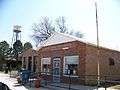 Mosquero Post Office & Water Tower
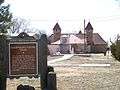 Goodnight-Loving Trail Marker
References
- ↑ "Find a County". National Association of Counties. Retrieved 2011-06-07.
- ↑ "US Gazetteer files: 2010, 2000, and 1990". United States Census Bureau. 2011-02-12. Retrieved 2011-04-23.
- ↑ "Annual Estimates of the Resident Population for Incorporated Places: April 1, 2010 to July 1, 2015". Retrieved July 2, 2016.
- ↑ "Census of Population and Housing". Census.gov. Retrieved June 4, 2015.
- ↑ "American FactFinder". United States Census Bureau. Retrieved 2008-01-31.
Municipalities and communities of Harding County, New Mexico, United States | ||
|---|---|---|
| Villages | 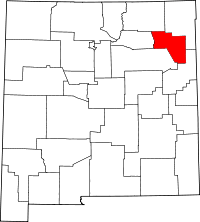 | |
| Unincorporated communities | ||
| Footnotes | ‡This populated place also has portions in an adjacent county or counties | |
Municipalities and communities of San Miguel County, New Mexico, United States | ||
|---|---|---|
| City | 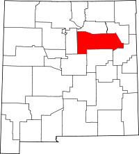 | |
| Villages | ||
| CDPs |
| |
| Other unincorporated communities | ||
| Ghost towns | ||
| Footnotes | ‡This populated place also has portions in an adjacent county or counties | |
Santa Fe (capital) | |
| Topics |
|
| Society | |
| Regions | |
| Cities | |
| Counties | |