Harding County, New Mexico
| Harding County, New Mexico | |
|---|---|
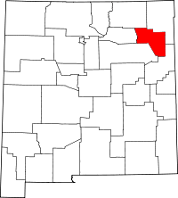 Location in the U.S. state of New Mexico | |
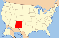 New Mexico's location in the U.S. | |
| Founded | March 4, 1921 |
| Named for | Warren G. Harding |
| Seat | Mosquero |
| Largest village | Roy |
| Area | |
| • Total | 2,126 sq mi (5,506 km2) |
| • Land | 2,125 sq mi (5,504 km2) |
| • Water | 0.4 sq mi (1 km2), 0.02% |
| Population | |
| • (2010) | 695 |
| • Density | 0.3/sq mi (0/km²) |
| Congressional district | 3rd |
| Time zone | Mountain: UTC-7/-6 |
| Website |
www |
Harding County is a county located in the U.S. state of New Mexico. As of the 2010 census, the population was 695,[1] making it the least populous county in the state, and the 14th-smallest county by population in the United States. Its county seat is the Village of Mosquero.[2] The county is named for United States President Warren G. Harding, and was created (from parts of Union and Mora Counties) on the day of his inauguration as President on March 4, 1921.
The only incorporated cities in Harding County are Roy and Mosquero.
Geography
According to the U.S. Census Bureau, the county has a total area of 2,126 square miles (5,510 km2), of which 2,125 square miles (5,500 km2) is land and 0.4 square miles (1.0 km2) (0.02%) is water.[3] It is divided between a high, nearly treeless prairie to the northwest (the southern limit of the High Plains), and a lower semi-desert rangeland to the southeast, by the eastern portion of the steep Canadian Escarpment. The Canadian River, in a deep and narrow canyon, forms the western border with Mora County; the southwest border runs along the edge of the Bell Ranch land in San Miguel County. The eastern part of Harding County is underlain in part by the Bravo Dome carbon dioxide gas field, which is commercially extracted.
Adjacent counties
- Union County - northeast
- Quay County - southeast
- San Miguel County - south
- Mora County - west
- Colfax County - northwest
National protected area
- Kiowa National Grassland (part)
Demographics
| Historical population | |||
|---|---|---|---|
| Census | Pop. | %± | |
| 1930 | 4,421 | — | |
| 1940 | 4,374 | −1.1% | |
| 1950 | 3,013 | −31.1% | |
| 1960 | 1,874 | −37.8% | |
| 1970 | 1,348 | −28.1% | |
| 1980 | 1,090 | −19.1% | |
| 1990 | 987 | −9.4% | |
| 2000 | 810 | −17.9% | |
| 2010 | 695 | −14.2% | |
| Est. 2015 | 698 | [4] | 0.4% |
| U.S. Decennial Census[5] 1790-1960[6] 1900-1990[7] 1990-2000[8] 2010-2013[1] | |||
2000 census
As of the census[9] of 2000, there were 810 people, 371 households, and 231 families residing in the county. The population density was 0.38 people per square mile (0.15/km²). There were 545 housing units at an average density of 0.26 per square mile (0.1/km²). The racial makeup of the county was 84.32% White, 0.37% Black or African American, 1.36% Native American, 10.62% from other races, and 3.33% from two or more races. 44.94% of the population were Hispanic or Latino of any race.
There were 371 households out of which 22.10% had children under the age of 18 living with them, 52.60% were married couples living together, 7.50% had a female householder with no husband present, and 37.50% were non-families. 35.30% of all households were made up of individuals and 21.00% had someone living alone who was 65 years of age or older. The average household size was 2.18 and the average family size was 2.84.
In the county the population was spread out with 20.20% under the age of 18, 4.60% from 18 to 24, 18.80% from 25 to 44, 28.10% from 45 to 64, and 28.30% who were 65 years of age or older. The median age was 49 years. For every 100 females there were 102.50 males. For every 100 females age 18 and over, there were 102.50 males.
The median income for a household in the county was $26,111, and the median income for a family was $36,667. Males had a median income of $22,750 versus $15,750 for females. The per capita income for the county was $16,240. About 12.90% of families and 16.30% of the population were below the poverty line, including 31.30% of those under age 18 and 11.30% of those age 65 or over.
2010 census
As of the 2010 United States Census, there were 695 people, 349 households, and 213 families residing in the county.[10] The population density was 0.3 inhabitants per square mile (0.12/km2). There were 526 housing units at an average density of 0.2 per square mile (0.077/km2).[11] The racial makeup of the county was 86.9% white, 1.2% American Indian, 0.3% black or African American, 10.2% from other races, and 1.4% from two or more races. Those of Hispanic or Latino origin made up 43.0% of the population.[10] In terms of ancestry, 11.0% were German, and 2.2% were American.[12]
Of the 349 households, 15.5% had children under the age of 18 living with them, 51.3% were married couples living together, 5.4% had a female householder with no husband present, 39.0% were non-families, and 34.7% of all households were made up of individuals. The average household size was 1.99 and the average family size was 2.49. The median age was 55.9 years.[10]
The median income for a household in the county was $33,750 and the median income for a family was $56,563. Males had a median income of $36,167 versus $29,111 for females. The per capita income for the county was $14,684. About 9.1% of families and 19.1% of the population were below the poverty line, including 11.6% of those under age 18 and 24.7% of those age 65 or over.[13]
Communities
See also
References
- 1 2 "State & County QuickFacts". United States Census Bureau. Retrieved September 29, 2013.
- ↑ "Find a County". National Association of Counties. Retrieved 2011-06-07.
- ↑ "2010 Census Gazetteer Files". United States Census Bureau. August 22, 2012. Retrieved January 2, 2015.
- ↑ "County Totals Dataset: Population, Population Change and Estimated Components of Population Change: April 1, 2010 to July 1, 2015". Retrieved July 2, 2016.
- ↑ "U.S. Decennial Census". United States Census Bureau. Retrieved January 2, 2015.
- ↑ "Historical Census Browser". University of Virginia Library. Retrieved January 2, 2015.
- ↑ "Population of Counties by Decennial Census: 1900 to 1990". United States Census Bureau. Retrieved January 2, 2015.
- ↑ "Census 2000 PHC-T-4. Ranking Tables for Counties: 1990 and 2000" (PDF). United States Census Bureau. Retrieved January 2, 2015.
- ↑ "American FactFinder". United States Census Bureau. Retrieved 2008-01-31.
- 1 2 3 "DP-1 Profile of General Population and Housing Characteristics: 2010 Demographic Profile Data". United States Census Bureau. Retrieved 2016-01-24.
- ↑ "Population, Housing Units, Area, and Density: 2010 - County". United States Census Bureau. Retrieved 2016-01-24.
- ↑ "DP02 SELECTED SOCIAL CHARACTERISTICS IN THE UNITED STATES – 2006-2010 American Community Survey 5-Year Estimates". United States Census Bureau. Retrieved 2016-01-24.
- ↑ "DP03 SELECTED ECONOMIC CHARACTERISTICS – 2006-2010 American Community Survey 5-Year Estimates". United States Census Bureau. Retrieved 2016-01-24.
 |
Colfax County | Union County | Union County | |
| Mora County | |
|||
| ||||
| | ||||
| San Miguel County | Quay County |
Municipalities and communities of Harding County, New Mexico, United States | ||
|---|---|---|
| Villages | | |
| Unincorporated communities | ||
| Footnotes | ‡This populated place also has portions in an adjacent county or counties | |
Santa Fe (capital) | |
| Topics |
|
| Society | |
| Regions | |
| Cities | |
| Counties | |
Coordinates: 35°52′N 103°49′W / 35.86°N 103.82°W