Villanueva, New Mexico
| Villanueva, New Mexico | |
|---|---|
| Unincorporated community | |
|
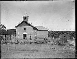
Church at Villanueva, around 1915 | |
 Villanueva Location within the state of New Mexico | |
| Coordinates: 35°16′0″N 105°21′39″W / 35.26667°N 105.36083°WCoordinates: 35°16′0″N 105°21′39″W / 35.26667°N 105.36083°W[1] | |
| Country | United States |
| State | New Mexico |
| County | San Miguel |
| Elevation[1] | 5,869 ft (1,789 m) |
| Population (2000) | |
| • Total | 267 |
| Time zone | MST (UTC-7) |
| • Summer (DST) | MDT (UTC-6) |
| ZIP code | 87583 |
| Area code | 505 |
| FIPS code | 35-83130 [1] |
| GNIS ID | 915912 [1] |
Villanueva is an Unincorporated community and census-designated place in San Miguel County, New Mexico, United States.[1] It is located along the Pecos River and New Mexico State Highway 3. Villanueva has the ZIP code 87583. The 87583 ZIP Code Tabulation Area had a population of 267 at the 2000 census.[2]
History
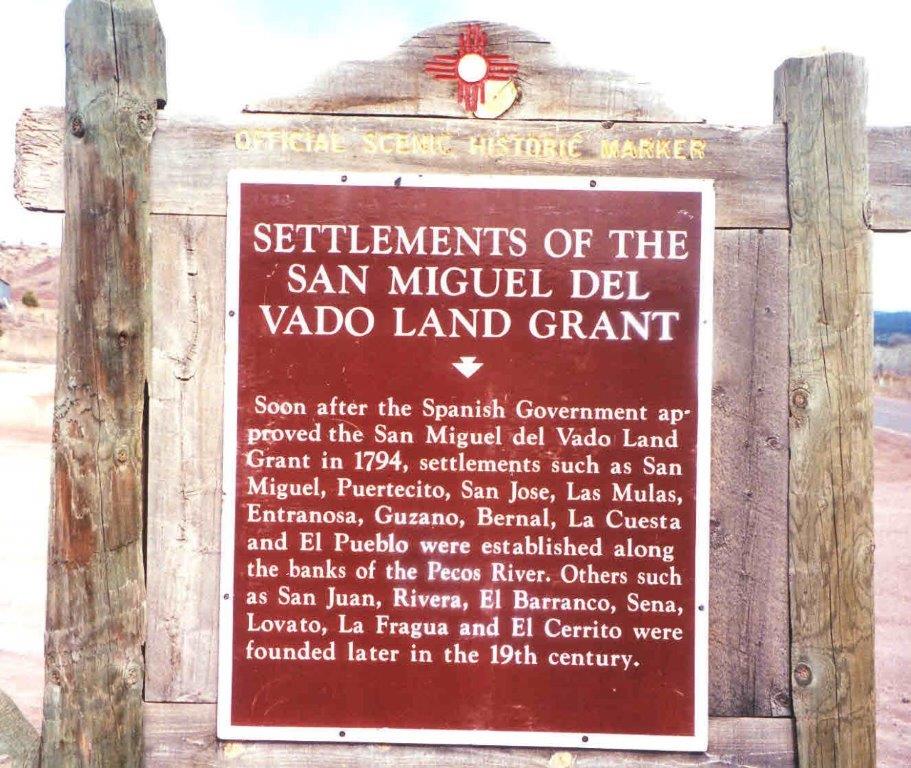
Villanueva, an old Spanish colonial village, was originally called La Cuesta[1] (Spanish, hill or slope) because the village sits on top of a steeply sloping hill or cuesta in the Pecos Valley.[3] Soon after the Spanish Government approved the San Miguel del Vado Land Grant in 1794, settlements were established along the banks of the Pecos River, such as Bernal, El Pueblo, Entrnosa, Guzano, La Cuesta, Las Mulas, Puertecito, San Jose, San Miguel.[4]
Some Cibolero buffalo hunters of the 19th century originated from La Cuesta and other Hispano communities along the Pecos River.[5]
In 1890, the community was renamed to Villanueva, for a prominent local family.[3]
Area attractions
East of Villanueva is Villanueva State Park, a colorful canyon cut by the Pecos River.
References
- 1 2 3 4 5 6 Geographic Names Information System (GNIS) details for Villanueva, New Mexico; United States Geological Survey (USGS); November 13, 1980.
- ↑ "American FactFinder". United States Census Bureau. Archived from the original on September 11, 2013. Retrieved 2008-01-31.
- 1 2 Geology of Villanueva area
- ↑ Settlements of the San Miguel Del Vado Land Grant; Official Scenic Historic Marker.
- ↑ "The Cibolero Trail: Across the Plains of Eastern New Mexico. http://www.over-land.com/st_cibolero.html
Further reading
- The Villanueva, New Mexico story; F. Stanley; 24 pages; 1970.
External links
- Villanueva community profile
- Villanueva State Park
- Photo, Pecos River at Villanueva State Park
- Geology of Villanueva area
- 1870 Census of La Cuesta (Villanueva), page 1, page 2
- Map of communities in San Miguel County
Municipalities and communities of San Miguel County, New Mexico, United States | ||
|---|---|---|
| City | 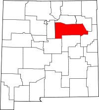 | |
| Villages | ||
| CDPs |
| |
| Other unincorporated communities | ||
| Ghost towns | ||
| Footnotes | ‡This populated place also has portions in an adjacent county or counties | |