Clovis, New Mexico
| Clovis, New Mexico | ||
|---|---|---|
| City | ||
| ||
| Motto: "A City On The Move - Come Grow With Us!" | ||
 Location of Clovis, New Mexico | ||
 Clovis, New Mexico Location in the United States | ||
| Coordinates: 34°24′45″N 103°12′17″W / 34.41250°N 103.20472°WCoordinates: 34°24′45″N 103°12′17″W / 34.41250°N 103.20472°W | ||
| Country | United States | |
| State | New Mexico | |
| County | Curry | |
| Incorporated | 1909[1] | |
| Government | ||
| • City Manager | Joe Thomas | |
| Area | ||
| • Total | 22.9 sq mi (59.3 km2) | |
| • Land | 22.7 sq mi (58.8 km2) | |
| • Water | 0.2 sq mi (0.4 km2) | |
| Elevation | 4,268 ft (1,301 m) | |
| Population (2010) | ||
| • Total | 37,775 | |
| • Density | 1,663/sq mi (642.1/km2) | |
| Time zone | Mountain (MST) (UTC-7) | |
| • Summer (DST) | MDT (UTC-6) | |
| ZIP code | 88101 88102 | |
| Area code(s) | 505, 575 | |
| FIPS code | 35-16420 | |
| GNIS feature ID | 0915815 | |
| Website |
www | |
Clovis is the county seat of Curry County, New Mexico, United States,[2] with a population of 37,775 as of the 2010 census, and a 2014 estimated population of 39,860.[3] Clovis is located in the New Mexico portion of the Llano Estacado, in the eastern part of the state.
A largely agricultural community, closely bordering Texas, it is noted for its role in early rock music history and for nearby Cannon Air Force Base. After the discovery of several "Clovis culture" sites in eastern North America in the 1930s, the Clovis people came to be regarded as the first human inhabitants who created a widespread culture in the New World. Clovis people are considered to be the ancestors of most of the indigenous cultures of the Americas. The Atchison, Topeka, & Santa Fe Railway system helped to establish Clovis over a hundred years ago, and for that railroad and its successor BNSF Railway continues to be a major hub of operations. Also notable is the Southwest Cheese Company, the largest cheddar cheese producer in North America.
It is the principal city of the Clovis Micropolitan Statistical Area, which is part of the larger Clovis-Portales CSA.
History
The eastern New Mexico region was home to the prehistoric Clovis culture, an anthropologically significant group of early Native Americans. Several remains have been found at the Blackwater Draw site (south of Clovis, near Portales), which remains a historical and tourist site.
Clovis began in 1906, when the Atchison, Topeka and Santa Fe Railway was being constructed through the area and railway engineers were ordered to choose a town site.[4] At first known as "Riley's Switch", it was renamed Clovis by the station master's daughter, who was studying about Clovis, the first Catholic king of the Franks, at the time.[5] The settlement built up quickly and in 1909 was incorporated.[5]
On August 24, 2008, eight prisoners escaped from the Clovis Jail by shimmying up plumbing pipes. The escape was highlighted on the television show America's Most Wanted.[6]
Clovis celebrated its centennial in 2009.
Geography
Clovis is located in southeastern Curry County at 34°24′45″N 103°12′17″W / 34.41250°N 103.20472°W (34.412509, −103.204611),[7] 9 miles (14 km) west of the Texas border. The city's geographic center is at an elevation of 4,281 feet (1,305 m) above sea level.[8]
U.S. Routes 60, 70, and 84 pass through the city. US 60 and 84 lead west 60 miles (97 km) to Fort Sumner, while US 70 leads southwest 19 miles (31 km) to Portales and 110 miles (180 km) to Roswell. The three highways lead east together to the state line at Texico, New Mexico, and Farwell, Texas. Cannon Air Force Base is 7 miles (11 km) west of the center of Clovis.
According to the United States Census Bureau, the city has a total area of 22.9 square miles (59.3 km2), of which 22.7 square miles (58.8 km2) is land and 0.2 square miles (0.4 km2), or 0.73%, is water[3] from the several artificial ponds in Clovis' multiple public parks.
Demographics
| Historical population | |||
|---|---|---|---|
| Census | Pop. | %± | |
| 1910 | 3,255 | — | |
| 1920 | 4,904 | 50.7% | |
| 1930 | 8,027 | 63.7% | |
| 1940 | 10,065 | 25.4% | |
| 1950 | 17,318 | 72.1% | |
| 1960 | 23,713 | 36.9% | |
| 1970 | 28,495 | 20.2% | |
| 1980 | 31,194 | 9.5% | |
| 1990 | 30,954 | −0.8% | |
| 2000 | 32,667 | 5.5% | |
| 2010 | 37,775 | 15.6% | |
| Est. 2015 | 39,480 | [9] | 4.5% |
As of the census[11] of 2000, there were 32,667 people, 12,458 households, and 8,596 families residing in the city. The population density was 1,458.9 people per square mile (563.3/km²). There were 14,269 housing units at an average density of 637.3 per square mile (246.1/km²). The racial makeup of the city was 71.3% White, 7.32% African American, 1.02% Native American, 1.62% Asian, 0.13% Pacific Islander, 14.98% from other races, and 3.63% from two or more races. Hispanic or Latino were 33.44% of the population.
There were 12,458 households out of which 36.3% had children under the age of 18 living with them, 49.8% were married couples living together, 14.9% had a female householder with no husband present, and 31.0% were non-families. 26.8% of all households were made up of individuals and 10.3% had someone living alone who was 65 years of age or older. The average household size was 2.57 and the average family size was 3.12.
In the city the population was 30.0% under the age of 18, 9.4% from 18 to 24, 28.1% from 25 to 44, 19.5% from 45 to 64, and 13.0% who were ages 65 or older. The median age was 33 years. For every 100 females there were 92.5 males. For every 100 females age 18 and over, there were 88.1 males.
The median income for a household in the city was $28,878, and the median income for a family was $33,622. Males had a median income of $26,586 versus $20,375 for females. The per capita income for the city was $15,561. About 17.2% of families and 21.0% of the population were below the poverty line, including 28.2% of those under age 18 and 14.6% of those age 65 or over.
Economics and industry

Like most of east-central New Mexico and west Texas, the surrounding area plays host to significant agriculture and ranching activities, including peanut and cotton farming and cattle ranching used for both meat and dairy production. Several processing plants exist for these products; in 2004 construction began on the Southwest Cheese Company plant between Clovis and Portales. The plant commenced operations in late 2005 and provided a small boost to the local economy by employing over 200 personnel. It is one of the largest plants of its type in the world, processing milk provided by the numerous local dairies in excess of 2.3 billion pounds of milk annually.[12]
The BNSF Railway operates a division point and large freight classification yard on its Southern Transcon at Clovis, with a dispatchers office here monitoring traffic over the Belen Cutoff. This 235-mile (378 km) rail corridor is one of the most heavily trafficked routes in the western United States, often with more than 100 mostly intermodal freight trains arriving and leaving Clovis daily.[13] The Southwestern Railroad, formerly the AT&SF Pecos Valley branch line, connects to the BNSF here, shipping potash from mines near Carlsbad.
Clovis' location adjacent to Cannon Air Force Base, a special operations base, has had a large impact on the community. Clovis hosts a local organization, the Committee of Fifty, whose stated purpose is to lobby to keep Cannon AFB open; it subsequently helped coordinate the successful campaign which resulted in the realignment of Cannon to its new special ops mission.[14]
Clovis Municipal Airport provides a base for general aviation and daily service by Boutique Airlines to and from Dallas/Fort Worth International Airport.
Health care
Plains Regional Medical Center is the primary hospital serving Clovis. It is part of the Presbyterian Hospital system based in Albuquerque.[15]
Architecture

Southwest, Spanish Mission, or Adobe architectural styles are prevalent, being considered representative of New Mexico. Much of Clovis architecture is indistinguishable from the group of styles prevalent throughout most small towns and suburbs since the 1930s.
The Hotel Clovis, a local landmark, opened on October 20, 1931. At the time of its construction it was the tallest building between Albuquerque and Dallas. The hotel was designed by architect Robert Merrill, combining an Art Deco exterior with Southwestern Indian interior. The elegant ballroom hosted such names as Louis Armstrong, Glenn Miller, Tommy Dorsey, and Hank Williams, and the nearby train depot supplied the hotel with most of its business. The hotel closed shortly after the Santa Fe Railroad discontinued passenger train service to Clovis in 1971. The building is currently being renovated into affordable housing. As of January 2013, housing is being offered to the community on a first come-first served basis, with some apartments being available now, and others on an "as finished" basis.
Downtown Clovis has three historic movie theaters, including the State Theater.
Climate and landscape

The climate is relatively temperate with low humidity and high winds. Summers are warm with occasional extreme heat and winters are cool with frequent, extreme cold. Severe thunderstorms are often in the spring with rainstorms prevalent during summer evenings. Tornadoes are known to occur and Clovis is located on the southern edge of Tornado Alley. Several inches of snowfall frequently occur each winter, typically for several weeks in January–February, often resulting in minor flooding due to the non-existent runoff system. High winds are common due to the flat, open land and regularly gust well above 30 MPH and average 12 MPH .[16] According to the Köppen Climate Classification system, Clovis has a semi-arid climate, abbreviated "BSk" on climate maps.[17]
| Climate data for Clovis, New Mexico | |||||||||||||
|---|---|---|---|---|---|---|---|---|---|---|---|---|---|
| Month | Jan | Feb | Mar | Apr | May | Jun | Jul | Aug | Sep | Oct | Nov | Dec | Year |
| Record high °F (°C) | 79 (26) |
83 (28) |
91 (33) |
99 (37) |
103 (39) |
110 (43) |
109 (43) |
110 (43) |
105 (41) |
98 (37) |
85 (29) |
91 (33) |
110 (43) |
| Average high °F (°C) | 51.1 (10.6) |
56.0 (13.3) |
62.8 (17.1) |
72.3 (22.4) |
80.8 (27.1) |
89.4 (31.9) |
92 (33) |
90.2 (32.3) |
83.7 (28.7) |
73.3 (22.9) |
60.7 (15.9) |
52.1 (11.2) |
72.0 (22.2) |
| Average low °F (°C) | 23.4 (−4.8) |
26.8 (−2.9) |
32.2 (0.1) |
41.1 (5.1) |
50.6 (10.3) |
59.6 (15.3) |
63.6 (17.6) |
62.2 (16.8) |
55.0 (12.8) |
44.0 (6.7) |
32.1 (0.1) |
25.1 (−3.8) |
43.0 (6.1) |
| Record low °F (°C) | −12 (−24) |
−17 (−27) |
−4 (−20) |
12 (−11) |
27 (−3) |
36 (2) |
50 (10) |
46 (8) |
31 (−1) |
13 (−11) |
−1 (−18) |
−9 (−23) |
−17 (−27) |
| Average precipitation inches (mm) | 0.48 (12.2) |
0.41 (10.4) |
0.66 (16.8) |
1.03 (26.2) |
1.92 (48.8) |
2.62 (66.5) |
2.59 (65.8) |
3.43 (87.1) |
2.17 (55.1) |
1.75 (44.4) |
0.74 (18.8) |
0.70 (17.8) |
18.5 (469.9) |
| Average snowfall inches (cm) | 2.5 (6.4) |
2.0 (5.1) |
1.5 (3.8) |
0.3 (0.8) |
0.1 (0.3) |
0 (0) |
0 (0) |
0 (0) |
0 (0) |
0.2 (0.5) |
1.5 (3.8) |
3.0 (7.6) |
11.1 (28.2) |
| Source: The Weather Channel[18] | |||||||||||||
Education
Public education
Clovis is served by several public schools making up the Clovis Municipal Schools:
- Elementary schools
- Arts Academy at Bella Vista
- Barry Elem.
- Cameo Elem.
- Highland Elem.
- James Bickley Elem.
- La Casita Elem.
- Lincoln-Jackson Pre-School
- Lockwood Elem.
- Los Ninos Pre-School
- Mesa Elem.
- Parkview Elem.
- Ranchvale Elem.
- Sandia Elem.
- Zia Elem.
- Middle schools
- Gattis Middle School
- Marshall Middle School
- Yucca Middle School
- Junior high school
- Clovis High School Freshman Campus
- High school
- Clovis High School
Private schools
- Clovis Christian School
- Eastern Plains Early/Head Start
Post-secondary education
For post-secondary education, there is one community college, Clovis Community College (CCC). Eastern New Mexico University is the nearest university, located 20 miles (32 km) south in Portales.
Culture
Clovis gave its name to stone-age spear points that were found locally in 1929. Clovis points are the characteristically-fluted projectile points associated with the North American Clovis culture. These artifacts date to the Paleoindian period, approximately 13,500 years ago.[19]
The arts
Performances including music and drama often take place at Clovis Community College, Eastern New Mexico University, and the Lyceum Auditorium, as well as at the Special Events Center, located adjacent to the county fairgrounds. The Clovis Music Festival is, locally, a high-profile event held annually at the beginning of September. The Clovis Civic Center hosts this and other entertainment events. The Special Events Center holds events such as rodeos, auctions, and concerts.
Popular music

The town achieved some local fame in the 1950s and 1960s when it was home to the Norman Petty Recording Studio, founded by musician Norman Petty, whose "Norman Petty Trio" topped charts with "Mood Indigo" and "Almost Paradise" in their lounge/pop style. Artists such as Buddy Holly, Buddy Knox, Jimmy Gilmer & The Fireballs, and The String-A-Longs had top-charting hits recorded there (Holly's "Peggy Sue" was recorded there in July 1957). Artists including Waylon Jennings, Charlie "Sugartime" Phillips, Bobby Fuller and Roy Orbison cut their earliest recordings at the studio. From the late '50s to the late '60s Petty had recordings on every major label in the USA and Canada.
Notable people
- Hank Baskett, former NFL football player; married to Kendra Wilkinson from The Girls Next Door[20]
- Kenny Bernstein, IndyCar and NASCAR team owner; record-setting drag racer
- D. J. Brigman, PGA Tour golfer[21]
- Odis Echols, songwriter
- Wayne Hale, former NASA engineer and Space Shuttle program manager
- Carl Hatch, U.S. senator for New Mexico from 1933-1949
- Fred K. Mahaffey, U.S. Army general
- Jerry Nuzum, NFL player for the Pittsburgh Steelers from 1948–1951
- Matt Othick, retired basketball player who played for the San Antonio Spurs[22][23]
- Norman Petty, musician, songwriter, record producer, and founder of Norman Petty Recording Studios[24]
- Angela Rockwood-Nguyen, actress who appeared in The Fast and The Furious (un-credited) and V.I.P.[25]
- Alvy Ray Smith (born 8 September 1943), pioneer in computer graphics; co-founder of the animation studio Pixar
- Mark Warford, director, photographer, and composer
References
- ↑ "About Clovis, NM". Retrieved October 6, 2007.
- ↑ "Find a County". National Association of Counties. Archived from the original on 2011-05-31. Retrieved 2011-06-07.
- 1 2 "Geographic Identifiers: 2010 Demographic Profile Data (G001): Clovis city, New Mexico". U.S. Census Bureau, American Factfinder. Retrieved October 23, 2014.
- ↑ http://curry.nmgenweb.us/Clovis.htm
- 1 2 Clovisnm.org
- ↑ Johnson, Sharna. "'America's Most Wanted' to air inmate escape Saturday." Clovis News Journal, September 3, 2008. Retrieved on Sep. 21, 2008.
- ↑ "US Gazetteer files: 2010, 2000, and 1990". United States Census Bureau. 2011-02-12. Retrieved 2011-04-23.
- ↑ Fallingrain.com
- ↑ "Annual Estimates of the Resident Population for Incorporated Places: April 1, 2010 to July 1, 2015". Retrieved July 2, 2016.
- ↑ "Census of Population and Housing". Census.gov. Archived from the original on May 11, 2015. Retrieved June 4, 2015.
- ↑ "American FactFinder". United States Census Bureau. Archived from the original on 2013-09-11. Retrieved 2008-01-31.
- ↑ Joseph P. Sánchez; Robert L. Spude; Art Gómez (26 September 2013). New Mexico: A History. University of Oklahoma Press. p. 323. ISBN 978-0-8061-5113-7.
- ↑ Fred W. Frailey, "Birthplace of the Transcon," Trains magazine, April 2007
- ↑ "Operation Keep Cannon"
- ↑ http://www.aanmpc.com/facilities.php
- ↑ "Average Wind Speeds". Historical Climate Information. Western Regional Climate Center. 2006.
- ↑ Climate Summary for Clovis, New Mexico
- ↑ "Average Weather for Clovis, NM – Temperature and Precipitation". Retrieved April 4, 2011.
- ↑ "A Clovis Spear Point". Archaeological Research Center. South Dakota State Historical Society. February 13, 2004.
- ↑ Eonline.com
- ↑ http://www.pgatour.com/players/player.24290.d-j-brigman.html
- ↑ http://basketball.realgm.com/player/Matt-Othick/GameLogs/44652
- ↑ http://www.basketball-reference.com/players/o/othicma01.html
- ↑ CNJonline.com
- ↑ IMDb.com
External links
| Wikimedia Commons has media related to Clovis, New Mexico. |
- City of Clovis official website
- Clovis Municipal Schools
- Clovis News Journal
- Clovis Curry County Chamber of Commerce
Municipalities and communities of Curry County, New Mexico, United States | ||
|---|---|---|
| Cities | 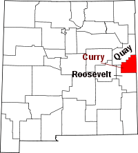 | |
| Villages | ||
| CDP | ||
| Unincorporated communities | ||
Santa Fe (capital) | |
| Topics |
|
| Society | |
| Regions | |
| Cities | |
| Counties | |