De Baca County, New Mexico
| De Baca County, New Mexico | |
|---|---|
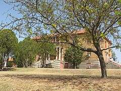 De Baca County Courthouse in Fort Sumner | |
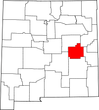 Location in the U.S. state of New Mexico | |
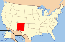 New Mexico's location in the U.S. | |
| Founded | February 28, 1917 |
| Named for | Ezequiel Cabeza De Baca |
| Seat | Fort Sumner |
| Largest village | Fort Sumner |
| Area | |
| • Total | 2,334 sq mi (6,045 km2) |
| • Land | 2,323 sq mi (6,017 km2) |
| • Water | 11 sq mi (28 km2), 0.5% |
| Population | |
| • (2010) | 2,022 |
| • Density | 0.9/sq mi (0/km²) |
| Congressional district | 2nd |
| Time zone | Mountain: UTC-7/-6 |
De Baca County is a county located in the U.S. state of New Mexico. As of the 2010 census, the population was 2,022,[1] making it the second-least populous county in New Mexico. Its county seat is Fort Sumner.[2] The county is named for Ezequiel Cabeza De Baca, the second elected Governor of New Mexico.[3]
Geography
According to the U.S. Census Bureau, the county has a total area of 2,334 square miles (6,050 km2), of which 2,323 square miles (6,020 km2) is land and 11 square miles (28 km2) (0.5%) is water.[4]
Adjacent counties
- Guadalupe County - north
- Quay County - northeast
- Roosevelt County - east
- Chaves County - south
- Lincoln County - west
Demographics
| Historical population | |||
|---|---|---|---|
| Census | Pop. | %± | |
| 1920 | 3,196 | — | |
| 1930 | 2,893 | −9.5% | |
| 1940 | 3,725 | 28.8% | |
| 1950 | 3,464 | −7.0% | |
| 1960 | 2,991 | −13.7% | |
| 1970 | 2,547 | −14.8% | |
| 1980 | 2,454 | −3.7% | |
| 1990 | 2,252 | −8.2% | |
| 2000 | 2,240 | −0.5% | |
| 2010 | 2,022 | −9.7% | |
| Est. 2015 | 1,828 | [5] | −9.6% |
| U.S. Decennial Census[6] 1790-1960[7] 1900-1990[8] 1990-2000[9] 2010-2013[1] | |||
2000 census
As of the census[10] of 2000, there were 2,240 people, 922 households, and 614 families residing in the county. The population density was 1 people per square mile (0/km²). There were 1,307 housing units at an average density of 1 per square mile (0/km²). The racial makeup of the county was 84.02% White, 0.04% Black or African American, 0.94% Native American, 0.22% Asian, 12.54% from other races, and 2.23% from two or more races. 35.27% of the population were Hispanic or Latino of any race.
There were 922 households out of which 27.20% had children under the age of 18 living with them, 56.60% were married couples living together, 7.30% had a female householder with no husband present, and 33.30% were non-families. 30.80% of all households were made up of individuals and 18.00% had someone living alone who was 65 years of age or older. The average household size was 2.35 and the average family size was 2.96.
In the county the population was spread out with 24.10% under the age of 18, 5.70% from 18 to 24, 21.70% from 25 to 44, 23.20% from 45 to 64, and 25.40% who were 65 years of age or older. The median age was 44 years. For every 100 females there were 96.00 males. For every 100 females age 18 and over, there were 92.10 males.
The median income for a household in the county was $25,441, and the median income for a family was $32,870. Males had a median income of $25,833 versus $18,487 for females. The per capita income for the county was $14,065. 17.70% of the population and 13.60% of families were below the poverty line. Out of the total people living in poverty, 23.30% are under the age of 18 and 15.00% are 65 or older.
2010 census
As of the 2010 United States Census, there were 2,022 people, 912 households, and 581 families residing in the county.[11] The population density was 0.9 inhabitants per square mile (0.35/km2). There were 1,344 housing units at an average density of 0.6 per square mile (0.23/km2).[12] The racial makeup of the county was 87.3% white, 0.6% American Indian, 0.1% black or African American, 7.9% from other races, and 3.9% from two or more races. Those of Hispanic or Latino origin made up 38.5% of the population.[11] In terms of ancestry, 17.5% were German, 13.7% were American, 9.6% were English, and 7.4% were Irish.[13]
Of the 912 households, 27.3% had children under the age of 18 living with them, 50.7% were married couples living together, 8.3% had a female householder with no husband present, 36.3% were non-families, and 32.7% of all households were made up of individuals. The average household size was 2.21 and the average family size was 2.78. The median age was 47.8 years.[11]
The median income for a household in the county was $30,643 and the median income for a family was $36,618. Males had a median income of $27,460 versus $20,980 for females. The per capita income for the county was $20,769. About 15.9% of families and 21.6% of the population were below the poverty line, including 39.0% of those under age 18 and 18.3% of those age 65 or over.[14]
Communities
Village
- Fort Sumner (county seat)
Census-designated place
Unincorporated communities
Notable people
- Legendary outlaw Billy the Kid was killed and buried in Fort Sumner.
See also
References
- 1 2 "State & County QuickFacts". United States Census Bureau. Retrieved September 29, 2013.
- ↑ "Find a County". National Association of Counties. Retrieved June 7, 2011.
- ↑ "De Baca County Extension Office". New Mexico State University. Retrieved July 14, 2012.
- ↑ "2010 Census Gazetteer Files". United States Census Bureau. August 22, 2012. Retrieved January 1, 2015.
- ↑ "County Totals Dataset: Population, Population Change and Estimated Components of Population Change: April 1, 2010 to July 1, 2015". Retrieved July 2, 2016.
- ↑ "U.S. Decennial Census". United States Census Bureau. Retrieved January 1, 2015.
- ↑ "Historical Census Browser". University of Virginia Library. Retrieved January 1, 2015.
- ↑ "Population of Counties by Decennial Census: 1900 to 1990". United States Census Bureau. Retrieved January 1, 2015.
- ↑ "Census 2000 PHC-T-4. Ranking Tables for Counties: 1990 and 2000" (PDF). United States Census Bureau. Retrieved January 1, 2015.
- ↑ "American FactFinder". United States Census Bureau. Retrieved January 31, 2008.
- 1 2 3 "DP-1 Profile of General Population and Housing Characteristics: 2010 Demographic Profile Data". United States Census Bureau. Retrieved 2016-01-24.
- ↑ "Population, Housing Units, Area, and Density: 2010 - County". United States Census Bureau. Retrieved 2016-01-24.
- ↑ "DP02 SELECTED SOCIAL CHARACTERISTICS IN THE UNITED STATES – 2006-2010 American Community Survey 5-Year Estimates". United States Census Bureau. Retrieved 2016-01-24.
- ↑ "DP03 SELECTED ECONOMIC CHARACTERISTICS – 2006-2010 American Community Survey 5-Year Estimates". United States Census Bureau. Retrieved 2016-01-24.
 |
Guadalupe County | Quay County | | |
| Lincoln County | |
Roosevelt County | ||
| ||||
| | ||||
| Chaves County |
Municipalities and communities of De Baca County, New Mexico, United States | ||
|---|---|---|
| Village | | |
| CDP | ||
| Unincorporated communities | ||
| Ghost town | ||
Santa Fe (capital) | |
| Topics |
|
| Society | |
| Regions | |
| Cities | |
| Counties | |
Coordinates: 34°28′18″N 104°14′44″W / 34.47167°N 104.24556°W