Monclar, Gers
| Monclar | |
|---|---|
 | |
 Monclar | |
|
Location within Occitanie region  Monclar | |
| Coordinates: 43°55′12″N 0°06′22″W / 43.92°N 0.1061°WCoordinates: 43°55′12″N 0°06′22″W / 43.92°N 0.1061°W | |
| Country | France |
| Region | Occitanie |
| Department | Gers |
| Arrondissement | Condom |
| Canton | Cazaubon |
| Intercommunality | Grand-Armagnac |
| Government | |
| • Mayor (2008–2014) | Josette Fitte |
| Area1 | 10.12 km2 (3.91 sq mi) |
| Population (2008)2 | 187 |
| • Density | 18/km2 (48/sq mi) |
| Time zone | CET (UTC+1) |
| • Summer (DST) | CEST (UTC+2) |
| INSEE/Postal code | 32264 / 32150 |
| Elevation |
92–149 m (302–489 ft) (avg. 130 m or 430 ft) |
|
1 French Land Register data, which excludes lakes, ponds, glaciers > 1 km² (0.386 sq mi or 247 acres) and river estuaries. 2 Population without double counting: residents of multiple communes (e.g., students and military personnel) only counted once. | |
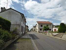
Monclar is a commune in the Gers department in southwestern France.
Geography
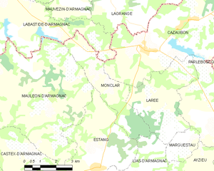
Monclar and its surrounding communes
Population
| Historical population | ||
|---|---|---|
| Year | Pop. | ±% |
| 1962 | 219 | — |
| 1968 | 162 | −26.0% |
| 1975 | 147 | −9.3% |
| 1982 | 144 | −2.0% |
| 1990 | 153 | +6.2% |
| 1999 | 129 | −15.7% |
| 2008 | 187 | +45.0% |
See also
References
| Wikimedia Commons has media related to Monclar (Gers). |
This article is issued from Wikipedia - version of the 8/27/2016. The text is available under the Creative Commons Attribution/Share Alike but additional terms may apply for the media files.