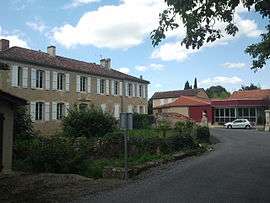
Boucagnères
| Boucagnères | |
|---|---|
 | |
 Boucagnères | |
|
Location within Occitanie region  Boucagnères | |
| Coordinates: 43°33′48″N 0°36′57″E / 43.5633°N 0.6158°ECoordinates: 43°33′48″N 0°36′57″E / 43.5633°N 0.6158°E | |
| Country | France |
| Region | Occitanie |
| Department | Gers |
| Arrondissement | Auch |
| Canton | Auch-Sud-Est-Seissan |
| Intercommunality | Val de Gers |
| Government | |
| • Mayor (2008–2014) | Jean-Luc Cabannes |
| Area1 | 6.16 km2 (2.38 sq mi) |
| Population (2008)2 | 136 |
| • Density | 22/km2 (57/sq mi) |
| Time zone | CET (UTC+1) |
| • Summer (DST) | CEST (UTC+2) |
| INSEE/Postal code | 32060 / 32550 |
| Elevation |
150–273 m (492–896 ft) (avg. 163 m or 535 ft) |
|
1 French Land Register data, which excludes lakes, ponds, glaciers > 1 km² (0.386 sq mi or 247 acres) and river estuaries. 2 Population without double counting: residents of multiple communes (e.g., students and military personnel) only counted once. | |
Boucagnères is a commune in the Gers department in southwestern France. It is situated near the river Gers (river), between Auch, the capital city of Gers, and Seissan, on the road D 929 in southern direction to Lannemezan.
Geography
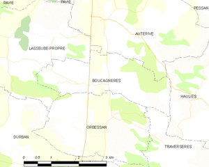
Boucagnères and its surrounding communes
Population
| Historical population | ||
|---|---|---|
| Year | Pop. | ±% |
| 1962 | 101 | — |
| 1968 | 107 | +5.9% |
| 1975 | 91 | −15.0% |
| 1982 | 125 | +37.4% |
| 1990 | 142 | +13.6% |
| 1999 | 141 | −0.7% |
| 2008 | 136 | −3.5% |
| 2010 | 148 | +8.8% |
| 2016 | 220 | +48.6% |
See also
References
| Wikimedia Commons has media related to Boucagnères. |
This article is issued from Wikipedia - version of the 9/6/2016. The text is available under the Creative Commons Attribution/Share Alike but additional terms may apply for the media files.