Saint-Clar
| Saint-Clar | ||
|---|---|---|
|
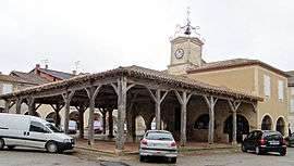
Covered market and town hall | ||
| ||
 Saint-Clar | ||
|
Location within Occitanie region  Saint-Clar | ||
| Coordinates: 43°53′34″N 0°46′15″E / 43.8928°N 0.7708°ECoordinates: 43°53′34″N 0°46′15″E / 43.8928°N 0.7708°E | ||
| Country | France | |
| Region | Occitanie | |
| Department | Gers | |
| Arrondissement | Condom | |
| Canton | Saint-Clar | |
| Intercommunality | Cœur de Lomagne | |
| Government | ||
| • Mayor (2008–2014) | David Taupiac | |
| Area1 | 17.91 km2 (6.92 sq mi) | |
| Population (2008)2 | 980 | |
| • Density | 55/km2 (140/sq mi) | |
| Time zone | CET (UTC+1) | |
| • Summer (DST) | CEST (UTC+2) | |
| INSEE/Postal code | 32370 / 32380 | |
| Elevation |
93–193 m (305–633 ft) (avg. 160 m or 520 ft) | |
|
1 French Land Register data, which excludes lakes, ponds, glaciers > 1 km² (0.386 sq mi or 247 acres) and river estuaries. 2 Population without double counting: residents of multiple communes (e.g., students and military personnel) only counted once. | ||
.svg.png)
Saint-Clar is a commune in the Gers department in southwestern France.
Geography
The river Arrats forms most of the commune's eastern border; the Auroue flows north through the western part of the commune.

History
Saint-Clar was founded in 1289 by Edward I, King of England and Duke of Aquitaine.
Structure
Its grid layout follows the standards of the typical Bastides grid. The basic architectural element is the central square boarded by arcades and stone and half-timbered houses. This square was the market place and the center of the communities’ economy.[1] The market hall (market building) in the central square was built with stone and with wooden pillars. Now it hosts the Town Hall (Place de la Mairie), which has a beautiful steeple with clock. This Town Hall was better known as “maison commune”.[2] Apart from that central square, Saint-Clar has one more arcaded square, both just a few steps away from each other. This is located in the south, in the original village, in the “castet bielh” (old quarter).
Population[3]
| Historical population | ||
|---|---|---|
| Year | Pop. | ±% |
| 1962 | 1,030 | — |
| 1968 | 1,033 | +0.3% |
| 1975 | 987 | −4.5% |
| 1982 | 972 | −1.5% |
| 1990 | 879 | −9.6% |
| 1999 | 868 | −1.3% |
| 2008 | 980 | +12.9% |
See also
| Wikimedia Commons has media related to Saint-Clar. |
References
- ↑ "An Introduction to Bastides (PPT), at About The Bastides". John Reps Collection. Cornell University Library. Retrieved 14 June 2016.
- ↑ "visit saint-clar gers - Site Officiel de l'Office de Tourisme Coeur de Lomagne (Saint-Clar et sa région)". www.tourisme-coeurdelomagne.com. Retrieved 20 June 2016.
- ↑ "INSEE - National Institute of Statistics and Economic Studies - France". www.insee.fr. Retrieved 20 June 2016.