| Name |
Image |
Location |
Status |
Intersecting roads |
Notes |
| Airport Circle (Newark) |
|
Newark |
Defunct |
US 1/9, NJ 21, US 22 |
Eliminated due to the construction of the NJ Turnpike and the subsequent expansion of Newark Airport. |
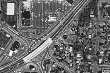
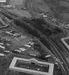
| Airport Circle |
 |
Pennsauken
39°56′01″N 75°04′56″W / 39.9337°N 75.0823°W / 39.9337; -75.0823 (Airport Circle) |
Modified |
US 30, US 130, NJ 70, NJ 38, Kaighn Ave. |
First traffic circle in New Jersey. Built 1925, opened 1927. Traffic lights, ramps and overpasses have been added.[3] |
| Airport Circle |
|
Egg Harbor Township
39°25′54″N 74°34′45″W / 39.4318°N 74.5791°W / 39.4318; -74.5791 (Airport Circle) |
Modified |
CR 563, CR 646, Amelia Earhart Blvd. |
Entrance to the Atlantic City International Airport. In 2011, the circle was revised to allow Delilah Road motorists to pass straight through the circle, plus the addition of traffic signals.[8] Direct connection ramps are proposed to help funnel traffic to and from the airport. |
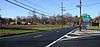
| Alexander Street Circle (Roundabout) |
|
Princeton
40°20′35″N 74°39′39″W / 40.3430°N 74.6608°W / 40.3430; -74.6608 (Alexander Street Roundabout) |
Recent |
Alexander Street, University Place |
Opened February 2014.[9][10] |
| Allwood Circle |
|
Clifton
40°50′35″N 74°09′35″W / 40.843°N 74.1596°W / 40.843; -74.1596 (Allwood Circle) |
Modified |
Allwood Road (CR 602), Bloomfield Avenue (CR 622) |
Reconfigured to roundabout alignment. |
| Allenwood Circle (Hurleys Corner Circle) |
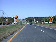 |
Allenwood
40°09′00″N 74°05′46″W / 40.1501°N 74.0960°W / 40.1501; -74.0960 (Allenwood Circle) |
Original |
NJ 34 & Allaire Road |
Built in the 1930s to support increased traffic in the area. |
| Asbury Park Circle |
|
Asbury Park
40°13′34″N 74°02′16″W / 40.2261°N 74.0377°W / 40.2261; -74.0377 (Asbury Park Circle) |
Original |
NJ 35, NJ 66, CR 16 |
Built in the 1940s to support increased traffic in the area. |
| Barrington Circle |
|
Barrington
39°52′34″N 75°02′58″W / 39.8762°N 75.0495°W / 39.8762; -75.0495 (Barrington Circle) |
Modified |
US 30, NJ 41 |
[3] |
| Bayway Circle |
|
Elizabeth
40°39′03″N 74°13′16″W / 40.6507°N 74.2211°W / 40.6507; -74.2211 (Bayway Circle) |
Modified |
US 1/9, New Jersey Route 439 |
Originally built to connect the Edgar Plank Road with Elizabeth's Spring Street (via a modified Carlton Street between Edgar Road and the circle and a brand-new highway between Spring Street and the circle), both of which are now part of US 1/9. |
| Berlin Circle |
|
Berlin Township
39°48′06″N 74°55′54″W / 39.8016°N 74.9316°W / 39.8016; -74.9316 (Berlin Circle) |
Defunct |
NJ 73, Berlin-Cross Keys Rd., Walker Ave. |
[3] |
| Boulevard and Passaic Avenue Circle |
|
Hasbrouck Heights, Wood-Ridge
40°51′29″N 74°04′54″W / 40.8580°N 74.0817°W / 40.8580; -74.0817 (Boulevard and Passaic Avenue Circle) |
Original |
Boulevard, Passaic Ave. |
While there wasn't a circle in this town originally, increased traffic required a circle to be built. |
| Bound Brook Circle |
|
Bound Brook
40°33′41″N 74°31′40″W / 40.5615°N 74.5278°W / 40.5615; -74.5278 (Bound Brook Circle) |
Recent |
East Main St and Bolmer Blvd. |
One of the newer traffic circles in the state. Built in the early-mid 2000s as a traffic calming solution at a former three-way intersection, and also as part of a realignment of the same intersection. |
| Brielle Circle |
|
Wall Township
40°06′58″N 74°04′22″W / 40.1162°N 74.0729°W / 40.1162; -74.0729 (Brielle Circle) |
Defunct |
NJ 34, NJ 35, NJ 70 |
Replaced with an at-grade intersection with jughandles. |
| Brookdale Circle |
 |
Lincroft
40°19′56″N 74°07′54″W / 40.3321°N 74.1317°W / 40.3321; -74.1317 (Brookdale Circle) |
Recent |
CR 520, Campus Drive
|
Added in 2007; previously an at-grade intersection with a traffic light. Located at the entrance to Brookdale Community College and the Lincroft Bible Church. |
| Brooklawn Circles |
|
Brooklawn |
|
|
|
| Browning Road Circle |
|
Pennsauken |
Defunct |
|
|
| Brunswick Circle |
|
Trenton and Lawrence
40°14′43″N 74°44′34″W / 40.2453°N 74.7428°W / 40.2453; -74.7428 (Brunswick Circle) |
|
US 206, US 1 Bus., CR 645 |
|
| Burnet Street Circle |
|
New Brunswick |
Defunct |
|
|
| Camp Merritt Memorial Circle |
|
Cresskill
40°56′29″N 73°58′36″W / 40.9413°N 73.9768°W / 40.9413; -73.9768 (Camp Merritt Memorial Circle) |
|
CR 505 (Knickerbocker Rd.), Madison Ave. |
|
| Cardiff Circle |
|
Egg Harbor
39°24′26″N 74°33′49″W / 39.4073°N 74.5637°W / 39.4073; -74.5637 (Cardiff Circle) |
Defunct |
US 40, US 322, CR 563 |
[7] |
| Charlotte Circle |
|
Jersey City
40°44′24″N 74°04′29″W / 40.7400°N 74.0748°W / 40.7400; -74.0748 (Charlotte Circle) |
Defunct |
|
|
| Chesterfield Circle |
 |
Chesterfield
40°07′50″N 74°39′43″W / 40.130592°N 74.661938°W / 40.130592; -74.661938 (Chesterfield Circle) |
New as of 2014 |
County Route 528, Old York Road (County Route 660) |
Technically a Roundabout |
| Clark Circle |
|
Clark
40°37′37″N 74°18′16″W / 40.6269°N 74.3044°W / 40.6269; -74.3044 (Clark Circle) |
Modified |
G.S. Pkwy., CR 613, CR 632 |
Exit 135 of the Garden State Pkwy., traffic lights added in 2007.[11] |
| College Drive Circle (Roundabout) |
|
Blackwood
39°47′16″N 75°02′37″W / 39.7877°N 75.0435°W / 39.7877; -75.0435 (College Drive Circle) |
|
CR 673 |
Built in 2009 at the entrance to Camden County College. 3 other traffic circles were built on college grounds, along with new service roads for improved safety and more accessibility to the college, near Route 42 and Route 168.[12] |
| Collingswood Circle |
|
Collingswood
39°55′08″N 75°05′20″W / 39.9189°N 75.0888°W / 39.9189; -75.0888 (Collingswood Circle) |
Defunct |
US 30, US 130, White Horse Pike, Woodlynne Ave. |
Replaced by an at-grade intersection with jughandles in 2009.[13] |
| Collingwood Circle |
|
Wall Township
40°13′09″N 74°07′42″W / 40.2192°N 74.1284°W / 40.2192; -74.1284 (Collingwood Circle) |
|
NJ 33, NJ 34, CR 547 |
|
| Cooper Landing Circle |
|
Cherry Hill
39°56′26″N 75°00′35″W / 39.9405°N 75.0098°W / 39.9405; -75.0098 (Cooper Landing Circle) |
Modified |
NJ 38, Cooper Landing Road, Church Road |
|
| Cranbury-Hightstown Circle |
|
Cranbury
40°17′31″N 74°31′14″W / 40.2919°N 74.5205°W / 40.2919; -74.5205 (Cranbury-Hightstown Circle) |
|
US 130, CR 539, CR 685 |
|
| Eatontown Circle |
|
Eatontown
40°17′27″N 74°03′06″W / 40.2909°N 74.0518°W / 40.2909; -74.0518 (Eatontown Circle) |
Defunct |
NJ 35, NJ 36 |
|
| Eisenhower Traffic Circle[14] |
 |
Lakehurst
40°00′42″N 74°19′33″W / 40.0117°N 74.3259°W / 40.0117; -74.3259 (Union Avenue Circle) |
|
NJ 70, Union Ave., South Union Ave., Pine St., Myrtle Ave. |
|
| Ellisburg Circle |
|
Cherry Hill
39°54′50″N 75°00′37″W / 39.9138°N 75.0102°W / 39.9138; -75.0102 (Ellisburg Circle) |
Defunct |
NJ 41, NJ 70, NJ 154 |
[3] |
| Flemington Circle |
 |
Flemington
40°30′09″N 74°51′12″W / 40.5026°N 74.8534°W / 40.5026; -74.8534 (Flemington Circle) |
|
US 202, NJ 12, NJ 31 |
To be replaced with a modern roundabout.[15] |
| Four Mile Circle |
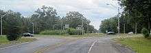 |
Southampton, Pemberton
39°53′56″N 74°35′47″W / 39.8989°N 74.5963°W / 39.8989; -74.5963 (Four Mile Circle) |
|
NJ 70, NJ 72, CR 644, CR 646 |
|
| Franklin Lake Circle |
|
Franklin Lakes
40°59′37″N 74°12′44″W / 40.9935°N 74.2123°W / 40.9935; -74.2123 (Franklin Lake Circle) |
|
|
|
| Freehold Circle |
|
Freehold
40°15′33″N 74°17′28″W / 40.2592°N 74.2912°W / 40.2592; -74.2912 (Freehold Circle) |
Defunct |
US 9, NJ 33 Bus., Manalapan Ave. |
|
| Ho-Ho-Kus Circle |
|
Ho-Ho-Kus |
Defunct |
|
|
| Lakehurst Circle |
 |
Lakehurst
40°00′46″N 74°18′19″W / 40.0128°N 74.3052°W / 40.0128; -74.3052 (Lakehurst Circle) |
|
NJ 37, NJ 70 |
|
| Laurelton Circle |
|
Brick Township
40°04′08″N 74°07′49″W / 40.0688°N 74.1303°W / 40.0688; -74.1303 (Laurelton Circle) |
Defunct |
NJ 70, NJ 88, CR 630 |
|
| Ledgewood Circle |
 |
Ledgewood
40°52′44″N 74°39′03″W / 40.8790°N 74.6508°W / 40.8790; -74.6508 (Ledgewood Circle) |
Defunct |
US 46, NJ 10, Circle Dr. |
[1]
Converted to 3-way signaled intersection (late 1990s) |
| Linden Circle |
|
Linden
40°38′24″N 74°17′16″W / 40.6399°N 74.2879°W / 40.6399; -74.2879 (Linden Circle) |
Defunct |
CR 607, CR 615 |
|
| Little Ferry Circle |
|
Little Ferry
40°51′10″N 74°02′02″W / 40.8529°N 74.0340°W / 40.8529; -74.0340 (Little Ferry Circle) |
Defunct |
US 46, Bergen Tpke. |
|
| Livingston Circle |
|
Livingston
40°47′47″N 74°20′29″W / 40.7963°N 74.3413°W / 40.7963; -74.3413 (Livingston Circle) |
Modified |
Eisenhower Parkway, NJ 10 (Mt. Pleasant Ave.), W Northfield Rd. |
|
| Main Street Circle |
 |
Flemington
40°30′06″N 74°51′31″W / 40.5018°N 74.8586°W / 40.5018; -74.8586 (Main Street Circle) |
|
NJ 12, Main St., South Main St., Reaville Ave. |
|
| Manasquan Circle |
|
Wall Township
40°07′56″N 74°03′55″W / 40.1323°N 74.0652°W / 40.1323; -74.0652 (Manasquan Circle) |
|
NJ 35, CR 524 Spur |
|
| Marlton Circle |
 |
Evesham Township
39°53′38″N 74°55′40″W / 39.8938°N 74.9278°W / 39.8938; -74.9278 (Marlton Circle) |
Defunct |
NJ 70, NJ 73 |
Replaced with an interchange in 2011.[16] |
| Medford Circle |
|
Medford
39°53′38″N 74°55′40″W / 39.8938°N 74.9277°W / 39.8938; -74.9277 (Medford Circle) |
Defunct |
|
|
| Monument Circle |
|
Englewood
40°53′48″N 73°58′47″W / 40.8967°N 73.9797°W / 40.8967; -73.9797 (Soldier's Monument in Monument Circle)[17] |
|
CR 505 (W Palisade Ave.), Tenafly Rd., Bennett Rd., Lafayette Ave. |
|
| Morlot Avenue Bridge Circle |
|
Paterson
40°55′23″N 74°08′29″W / 40.9230°N 74.1413°W / 40.9230; -74.1413 (Morlot Avenue Bridge Circle) |
Defunct |
NJ 20, CR 651 |
|
| Netcong Circle |
|
Netcong
40°53′48″N 74°42′01″W / 40.8968°N 74.7003°W / 40.8968; -74.7003 (Netcong Circle) |
Defunct |
US 46, NJ 183 |
Converted to 4-way intersection (August 2013) |
| Park Avenue and Passaic Avenue |
|
Rutherford
40°49′35″N 74°06′26″W / 40.8263°N 74.1072°W / 40.8263; -74.1072 |
Modified |
|
|
| Pennington Circle |
 |
Pennington
40°18′30″N 74°47′12″W / 40.3082°N 74.7866°W / 40.3082; -74.7866 (Pennington Circle) |
|
NJ 31, CR 546, CR 640 |
Metering lights added in late 2015[18] |
| Penns Neck Circle |
 |
West Windsor
40°19′53″N 74°38′17″W / 40.3315°N 74.6380°W / 40.3315; -74.6380 (Penns Neck Circle) |
Modified |
US 1, CR 571 |
|
| Pole Tavern Circle |
|
Upper Pittsgrove
39°37′01″N 75°13′46″W / 39.6170°N 75.2294°W / 39.6170; -75.2294 (Pole Tavern Circle) |
|
US 40, NJ 77, CR 604, CR 635 |
|
| Pudgy Circle |
|
McGuire AFB, New Hanover Township
40°02′07″N 74°35′12″W / 40.0354°N 74.5868°W / 40.0354; -74.5868 (Pudgy Circle) |
|
McGuire Blvd, First Street |
|
| Race Track Circle |
|
Cherry Hill
39°55′10″N 75°02′03″W / 39.9194°N 75.0343°W / 39.9194; -75.0343 (Race Track Circle) |
Defunct |
NJ 70, CR 644 |
[3] |
| Red Lion Circle |
 |
Southampton
39°53′14″N 74°44′28″W / 39.8872°N 74.7411°W / 39.8872; -74.7411 (Red Lion Circle) |
|
US 206, NJ 70 |
|
| Ridgefield Circle |
|
Ridgefield
40°49′59″N 74°00′37″W / 40.8331°N 74.0103°W / 40.8331; -74.0103 (Ridgefield Circle) |
Defunct |
US 1, NJ 39, Hendricks Causeway |
|
| Route 12 Circle / Dvoor's Circle |
 |
Raritan Township
40°30′16″N 74°52′16″W / 40.5044°N 74.8712°W / 40.5044; -74.8712 (Route 12 Circle) |
|
NJ 12, CR 523, Mine St. |
|
| Routes 1 & 130 Circle |
|
North Brunswick
40°27′46″N 74°27′19″W / 40.4627°N 74.4553°W / 40.4627; -74.4553 (Routes 1 & 130 Circle) |
Defunct |
US 1, US 130, NJ 171 |
Replaced by at-grade intersection, now an interchange. |
| Somers Point Circle |
 |
Somers Point
39°18′31″N 74°35′57″W / 39.3087°N 74.5993°W / 39.3087; -74.5993 (Somers Point Circle) |
Defunct |
NJ 52, CR 559, CR 585 |
Replaced by an intersection with traffic signals.[19][20] |
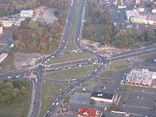
| Somerville Circle |
 |
Bridgewater, Raritan
40°34′33″N 74°37′44″W / 40.5757°N 74.6290°W / 40.5757; -74.6290 (Somerville Circle) |
Modified |
US 202, US 206, NJ 28 |
An overpass and traffic lights were added in the 1990s.[6] |
| Station Square |
 |
Rutherford
40°49′42″N 74°06′04″W / 40.8284°N 74.1011°W / 40.8284; -74.1011 (Station Square) |
Modified |
Park Avenue, Orient Way, Union Avenue, and Erie Avenue |
Rebuilt August 2003 - 2005 |
| Teaneck Circle |
|
Teaneck |
Defunct |
|
|
| Tonnele Circle |
 |
Jersey City
40°44′22″N 74°03′55″W / 40.7394°N 74.0654°W / 40.7394; -74.0654 (Tonnele Circle) |
Modified |
US 1/9, US 1/9 Truck, NJ 139, Tonnele Ave. |
|
| Victory Circle |
 |
Sayreville
40°29′46″N 74°17′52″W / 40.4962°N 74.2978°W / 40.4962; -74.2978 (Victory Circle) |
Defunct |
US 9, NJ 35, Chevalier Ave., Main St. |
Replaced with a diamond interchange in 2006.[21] |
| Watchung Circle |
|
Mountainside
40°41′14″N 74°21′50″W / 40.6872°N 74.3639°W / 40.6872; -74.3639 (Watchung Circle) |
|
CR 645, CR 642 |
|
| Westfield Circle |
|
Westfield
40°38′55″N 74°21′01″W / 40.6485°N 74.3503°W / 40.6485; -74.3503 (Westfield Circle) |
|
CR 509, CR 610, NJ 28, Westfield Ave., Watterson St. |
Expanded to two lanes in 2005 with one way designations added to Watterson St. (Inbound), and Westfield Ave. (Outbound) |
| White Horse Circle |
|
White Horse
40°11′18″N 74°42′17″W / 40.1882°N 74.7048°W / 40.1882; -74.7048 (White Horse Circle) |
Modified |
US 206, CR 524, CR 533 |
|