New Jersey Route 88
| ||||
|---|---|---|---|---|
 | ||||
| Route information | ||||
| Maintained by NJDOT | ||||
| Length: | 10.02 mi[1] (16.13 km) | |||
| Existed: | 1953 – present | |||
| Major junctions | ||||
| West end: |
| |||
| ||||
| East end: |
| |||
| Location | ||||
| Counties: | Ocean | |||
| Highway system | ||||
| ||||

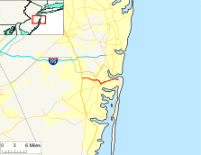
Route 88 is a state highway in the northern part of Ocean County, New Jersey, United States. It runs 10.02 mi (16.13 km) from an intersection with U.S. Route 9 (US 9) and County Route 547 (CR 547) in Lakewood Township to an intersection with Route 35 in Point Pleasant. It is a two-lane undivided road that passes through mostly residential and commercial areas. The route intersects CR 549 in Lakewood, Route 70 in Brick Township at the former Laurelton Circle, and CR 549 Spur in Point Pleasant. The road is mentioned in the lyrics of the 1973 song "Spirit in the Night" by Bruce Springsteen.
The route was built as a gravel county road in 1903 and became part of pre-1927 Route 4, a route that was to run from Absecon to Rahway, in 1916. US 9 was designated along this stretch of road in 1926 when the U.S. Highway System was created. A year later, in 1927, this portion of pre-1927 Route 4 became a part of Route 35, a route that was to from Lakewood to South Amboy. By the 1940s, US 9 was moved off this road to follow its current alignment between Lakewood and South Amboy. In 1953, Route 35 was realigned to follow a portion of Route 37 between Point Pleasant and Seaside Heights, and Route 88 was designated along the former alignment of Route 35 between Lakewood and Point Pleasant. The Laurelton Circle at Route 70, built in 1937, was replaced with the current intersection by the 1990s.
Route description


Route 88 begins at an intersection with US 9 and CR 547 in Lakewood Township, and heads eastward on Main Street, a two-lane undivided road.[1] The road heads through the downtown before heading into wooded residential areas, where it becomes Ocean Avenue at the Pearl Street intersection before coming to a junction with CR 20. Past this intersection, the route heads through a mix of residences and businesses with some woodland. Route 88 intersects CR 623, where it heads through a commercial district, crossing CR 549.[1][2] A short distance later, the route passes under the Garden State Parkway without an interchange before crossing the Metedeconk River into Brick Township.[1] Here, the road heads through a mix of residential and commercial areas, intersecting CR 64, CR 44, CR 40, and CR 16.[1][2] It turns south and intersects CR 40 before crossing Route 70.[1]
Past this intersection, Route 88 briefly splits into a one-way pair. Here, the eastbound direction follows Princeton Avenue southeast before turning north onto Post Road, with CR 630 continuing along Princeton Avenue, while westbound Route 88 follows Princeton Post Road.[1] Past the one-way pair, the route continues northeast on Princeton Post Road, which passes by numerous businesses.[1][2] Along this stretch of road Route 88 intersects several county routes, including CR 64 again, CR 42, CR 10, and CR 54. The route heads into Point Pleasant, where it intersects CR 56 before crossing Beaver Dam Creek and becoming Sea Avenue.[1] From here, the road crosses CR 632 before heading east and intersecting CR 549 Spur and CR 630. After this intersection, Route 88 crosses the Point Pleasant Canal (part of the Intracoastal Waterway) on the Veterans Memorial Bridge, a lift bridge, before heading east through residential areas with some businesses.[1][2] Here, the road intersects CR 633/CR 10, CR 6, and CR 604. A short distance later, Route 88 ends at an intersection with Route 35 on the border of Point Pleasant and Point Pleasant Beach.[1]
History
What is modern-day Route 88 was first built as a hard gravel county road back in 1903, the first such road in Ocean County.[3] In 1916, this road was designated as a part of pre-1927 Route 4, a state road that was to run from Absecon north to Rahway.[4] With the creation of the U.S. Highway System in 1926, US 9 was also designated along this route, running concurrent with Route 4.[5][6] In the 1927 New Jersey state highway renumbering a year later, Route 35 replaced this portion of pre-1927 Route 4 as part of its route from Lakewood to South Amboy.[7][8] By the 1940s, US 9 was moved off this portion of Route 35 to follow its current alignment along Route 4 between Lakewood and South Amboy.[9] In the 1953 New Jersey state highway renumbering, Route 35 was realigned to follow what was a part of Route 37 between Point Pleasant and Seaside Heights, and Route 88 was designated along the former alignment of Route 35 between Lakewood and Point Pleasant.[10][11] A traffic circle called the Laurelton Circle, built in 1937, once existed at the intersection with Route 70; it was replaced with its current configuration by the 1990s.[12] The current lift bridge that crosses the Point Pleasant Canal, the Veterans Memorial Bridge, opened in 1986 replacing an obsolete bascule lift bridge completed in 1928.[13][14]
Route 88 was referred to in the 1973 song "Spirit in the Night" by Bruce Springsteen on his debut album Greetings from Asbury Park, N.J..[15][16]
Major intersections
The entire route is in Ocean County.
| Location | mi[1] | km | Destinations | Notes | |
|---|---|---|---|---|---|
| Lakewood Township | 0.00 | 0.00 | Western terminus | ||
| 3.24 | 5.21 | ||||
| Brick Township | 5.20 | 8.37 | Former Laurelton Circle | ||
| Point Pleasant | 8.88 | 14.29 | |||
| 10.02 | 16.13 | Eastern terminus | |||
| 1.000 mi = 1.609 km; 1.000 km = 0.621 mi | |||||
See also
 U.S. Roads portal
 New Jersey portal
References
- 1 2 3 4 5 6 7 8 9 10 11 12 "Route 88 straight line diagram" (PDF). New Jersey Department of Transportation. Retrieved 2009-07-09.
- 1 2 3 4 Google (2009-07-09). "overview of New Jersey Route 88" (Map). Google Maps. Google. Retrieved 2009-07-09.
- ↑ "Timelines of History". Point Pleasant Historical Society. Retrieved 2009-07-10.
- ↑ 1916 Annual Report (Report). New Jersey Department of Transportation. 1916.
- ↑ Bureau of Public Roads & American Association of State Highway Officials (November 11, 1926). United States System of Highways Adopted for Uniform Marking by the American Association of State Highway Officials (Map). 1:7,000,000. Washington, DC: U.S. Geological Survey. OCLC 32889555. Retrieved November 7, 2013 – via University of North Texas Libraries.
- ↑ Map of New Jersey (Map). Tydol Trails. 1927. Retrieved February 9, 2011.
- ↑ State of New Jersey, Laws of 1927, Chapter 319.
- ↑ 1927 New Jersey Road Map (Map). State of New Jersey. Retrieved 2008-10-08.
- ↑ Map of Pennsylvania and New Jersey (Map). Cartography by H.M. Gousha. Mid-West Map Co. 1941. Retrieved 2009-03-29.
- ↑ "1953 renumbering". New Jersey Department of Highways. Retrieved July 31, 2009.
- ↑ "New Road Signs Ready in New Jersey". The New York Times. December 16, 1952. Retrieved 2009-07-20.
- ↑ Donatiello, Eugene E. and John G. Leavey (1999). Brick Township. Arcadia Publishing. ISBN 0-7385-0332-0. Retrieved 2009-07-10.
- ↑ Carney, Leo H. (August 10, 1986). "NEW JERSEY JOURNAL". The New York Times. Retrieved August 29, 2016.
- ↑ Woolley, Jerry; Heim, Jeff. "Ninety years of dreaming and planning - The Point Pleasant Canal". The Point Pleasant Historical Society. Archived from the original on February 24, 2007. Retrieved August 29, 2016.
- ↑ Marsh, D. (1981). Born to Run. pp. 66–74. ISBN 0-440-10694-X.
- ↑ Sawyers, J. (2006). Tougher Than the Rest. pp. 9–10. ISBN 978-0-8256-3470-3.
External links
| Wikimedia Commons has media related to New Jersey Route 88. |