Geography of New Jersey

New Jersey is a state within the United States of America that lies on the north eastern edge of the North American continent. It not shares a land border with the state of State of New York along the north, ratified by both states after the New York – New Jersey Line War. New Jersey is slightly larger than the country of Kuwait.
The Atlantic Ocean is east of the state. It is separated from New York, in particular the boroughs of the Bronx and Manhattan in New York City by the Hudson River, and from Staten Island by the Kill van Kull and the Arthur Kill. Liberty Island is an exclave of State of New York in New Jersey waters in Upper New York Bay. Ellis Island, also in the Upper Bay, and Shooter's Island, in Newark Bay, each have sections belonging to either of the two states.[1]
On its west, New Jersey is flanked by the Delaware River that forms its border with the Commonwealth of Pennsylvania and Delaware Bay which separates New Jersey from the State of Delaware. However, due to a fluke in a colonial land grant for the city of New Castle, Delaware (called The Twelve-Mile Circle), there is a small amount of Delaware territory in contiguous New Jersey. Finns Point, piers at Penns Grove, New Jerseys Grove and Pennsville, and Artificial Island, the tip of a small peninsula[2] at Lower Alloways Creek are connected to Salem County. A coal pier in Logan Township also extends into the river. New Jersey's natural regions were formed by glaciers.
Area

New Jersey is ranked 47th of the fifty states that comprise the United States of America in terms of area. The total area of the state is 8,729 square miles (22,610 km2), of which 14.9% or 1,304 square miles (3,380 km2) is water, and 85.1%, or 7,425 square miles (19,230 km2), is land. New Jersey spans 70 miles (110 km) at its widest, and 130 miles (240 km) in length.
Due to its small size, New Jersey, which ranks eleventh in the nation in terms of population with 8,791,894 people, ranks first in population density, with 1,189 inhabitants per square mile (459/km2). However, while this offers the impression that New Jersey is entirely urban or suburban, it is not. Large swaths of northwestern and southern New Jersey are extremely rural. For example, Walpack Township in Sussex County, has a population of 39 and an area of 26 square miles (67 km2).
Political geography

The State of New Jersey is divided into 21 counties, which contain a total of 566 municipalities. Like many New England states, all land in New Jersey is incorporated. New Jersey municipalities have a strong tradition of independent home rule which, as a result, means that county government is comparatively weaker than in other states and more open to criticisms of waste and ineffectiveness.[3]
Climate
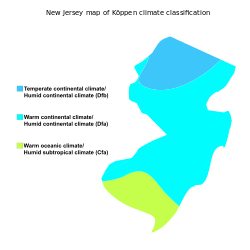
Southern New Jersey has a humid subtropical climate while a humid continental climate (Microthermal Climate) prevails in the northwest, according to the Köppen climate classification. New Jersey's climate is vastly affected by its proximity to the Atlantic Ocean.

- Winter is typically cold. The lows usually hover in the 20s °F (down to -10 °C) and can frequently dip below 0 °F (−18 °C) in the northwestern sections of the state. New Jersey winters often feature snowstorms known as Nor'easters that can paralyze the area with over a foot of snow. However, a variation in the climate also occasionally renders winter mild and almost snowless in sections of South Jersey near the Atlantic coastline. In the Coastal and southern portions of the state, frequently precipitation falls as rain in the winter despite it snowing in the northwestern portion.
- Springs are mild, averaging in the 50s °F (10 to 15 °C) in late March to the lower 80s °F (25-30 °C) in early June. The weather is unpredictable and brings relatively cool summers as an occasional surprise, and huge snowstorms arriving as late as the second week in April (significant snow after mid-March is fairly rare though). Thunderstorms are common in spring.
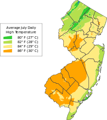
- Summers in New Jersey tend to be hot and humid, with temperatures often exceeding 90 °F (32 °C), although high temperatures above 100 °F (38 °C) are uncommon. Humidity levels are usually quite high in July and August. Thunderstorms are common in summer. Hurricanes are considered to be a major threat to the area (and especially the Jersey Shoreline communities in Monmouth, Ocean, Atlantic and Cape May counties). While relatively infrequent compared to areas south and east, a direct hit could cause large loss of life and billions of dollars in damage due to the high population in coastal areas.
- Autumns are comfortable in New Jersey and similar to spring in temperature. However, the weather is notably unpredictable and travelers are advised to check forecasts and bring several layers of clothing in late fall and in the early spring months (e.g., November, March, April) as temperatures do fluctuate quickly at these times of year.
The temperatures vary greatly from the northernmost part of New Jersey to the southernmost part of New Jersey. For example, these are the average high and low temperatures for Cape May, near the state's southernmost ocean-facing point, Sussex, in the mountainous northwest, and Trenton, the state capital located roughly midway between the two:
| North | Middle | South | ||||
|---|---|---|---|---|---|---|
| High | Low | High | Low | High | Low | |
| January | 27 | 7 | 32 | 10 | 39 | 27 |
| February | 38 | 16 | 41 | 26 | 43 | 28 |
| March | 47 | 25 | 47 | 33 | 51 | 35 |
| April | 59 | 41 | 61 | 45 | 60 | 48 |
| May | 70 | 50 | 71 | 52 | 76 | 69 |
| June | 78 | 58 | 80 | 61 | 79 | 62 |
| July | 83 | 59 | 89 | 67 | 87 | 67 |
| August | 82 | 57 | 88 | 65 | 85 | 66 |
| September | 74 | 45 | 65 | 57 | 73 | 60 |
| October | 63 | 37 | 64 | 45 | 66 | 49 |
| November | 51 | 30 | 54 | 37 | 56 | 40 |
| December | 20 | 0 | 32 | 15 | 40 | 31 |
| (Temperatures above are Fahrenheit)
Data source:[4] | ||||||
All-time temperature extremes recorded in New Jersey include 110 °F (43 °C) on July 10, 1936 in Runyon and −34 °F (−37 °C) on January 5, 1904 in River Vale.[5]
Rivers
New Jersey rivers includes streams formally designated as rivers. There are also smaller streams (i.e., branches, creeks, drains, forks, licks, runs, etc.) in the state. Major rivers include the Manasquan, Maurice, Mullica, Passaic, Rahway, Raritan, Musconetcong, and Delaware rivers. Historically, the Delaware and Raritan rivers have provided transportation of goods and people inland from the Atlantic Ocean, and were once connected by the Delaware and Raritan Canal. Today, these rivers, and the streams that feed them, provide sport and recreation for many people. The Raritan River in Middlesex County is often considered the borderline between North and South/Central Jersey, although it is not official.
Geology
Around 250 million years ago, during the Paleozoic and Mesozoic eras, the area that is today New Jersey bordered northern Africa as part of the supercontinent of Pangea. The pressure of the collision between North America and Africa gave rise to the Appalachian Mountains. Around 200 million years ago, Pangea began to break apart, separating the North American continent from the African continent. Around 18,000 years ago, the most recent ice age resulted in glaciers that reached New Jersey. As the glaciers retreated, they left behind Lake Passaic, as well as many rivers, swamps, and gorges.[6]
Physiographic Provinces
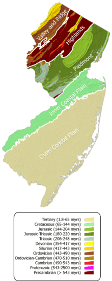
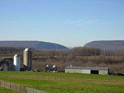
New Jersey is a region with a high variety of geographical features in a small area. The area can be broken into five regions, corresponding roughly to geological zones. These regions from north to south are the Appalachian Valley and Ridge, Highlands, Newark Basin Piedmont, Inner Coastal Plain, and the Outer Coastal Plain.
Appalachian Valley and Ridge Physiographic Province

The Appalachian Valley and Ridge lies in the northwestern corner of the state and includes the Kittatinny Mountains, several smaller valleys and the popular Delaware Water Gap. The state's highest point, the aptly named High Point is within this area, at 1,803 feet (550 m). Most of the state's section of the Appalachian Trail runs through this area. The province is bounded on the southeast by an unconformity between Cambrian and Precambrian formations.
Highlands Physiographic Province
The Highlands Physiographic Province is a geological formation composed primarily of Precambrian igneous and metamorphic rock running from the Delaware River near Musconetcong Mountain, northeast through the Skylands Region of New Jersey along the Bearfort Ridge and the Ramapo Mountains. Numerous abandoned mines dot the region, dating from the 18th and 19th centuries when iron, copper, zinc and other minerals were extracted from the formations. The glaciated northern half of the province has an abundance of lakes and reservoirs which serve as water supplies for the urban areas to the east. The region's watershed is protected by the Highlands Water Protection and Planning Act.
Newark Basin Piedmont
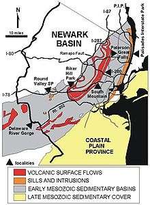
The Newark Basin is a region in northern New Jersey defined by the boundaries of a sediment-filled rift basin. This basin was formed when the supercontinent Pangaea began to split approximately 220 million years ago, causing several large depressions to form due to extension, which then filled with sediment. The basin itself extends from Rockland County in the southern tip of New York to south-eastern Pennsylvania. It lies within the broader region known as the Piedmont, a crescent-shaped area characterized by smooth topography and large volumes of sediments. Like the Piedmont, the Newark Basin has gentle topography consisting of red bed clastic sediments with occasional igneous rock formations, such as the Palisades Sill and the Watchung basalt flows; these igneous features are responsible for the dramatic elevation changes observed in the region, such as The Palisades and the Watchung Mountains, respectively. The boundaries of the Newark Basin, as well as major highways, are shown on the map at left.
For the geological history of the region, see Newark Basin.
Inner Coastal Plain
The Inner Coastal Plain province consists of lowlands and rolling hills underlain by Cretaceous deposits. Surficial geology in this region contains a number of fossils. The Monmouth County Park system, for example, includes a number of creeks where students and enthusiasts can gain real field exposure to cretaceous geology and paleontology. (Always check with the park service staff regarding permissibility before entering any field site.) The region's northwest border lies along the Piedmont fall line. Fertile, loamy soil makes the land ideal for agriculture and is responsible for New Jersey's nickname of the "Garden State". Its deposits of Greensand marl containing potash were used since colonial days by farmers to fertilize their fields.

Outer Coastal Plain
The outer coastal plain consists of unconsolidated Tertiary deposits of sands, silt, and gravels. The soils are sandy with less clay than the inner coastal plain, and are more acidic and dry. The lack of fertility makes much of the region unsuitable for agriculture and large areas remain undeveloped. The sandy Pine Barrens, an area that is agriculturally poor but species rich, occupy the center of the province. Blueberries and cranberries have been cultivated in lowland bogs that have accumulated depths of organic matter.
Along the coast, sandy beaches attract a recreation industry, and the offshore barrier islands are popular vacation destinations.
Natural environment
New Jersey's natural environment preserves a range of habitats ranging from the Atlantic shore to the Appalachian Mountains.[7] The sandy uplands of South Jersey are home to the Atlantic coastal pine barrens. Surrounding the Pine Barrens, along the coast and covering the Inner Coastal Plain and Piedmont, are the Northeastern coastal forests. The Highlands consist of Appalachian-Blue Ridge forests which grade into Allegheny Highlands forests in the far northeast.[8]
Tourist regions
New Jersey State Department of Tourism distinguishes six distinct tourist regions: the Gateway, Greater Atlantic City, the Southern Shore Region, the Delaware River Region, the Shore Region and the Skylands Region.[9]
Cultural regions
New Jersey's ethnic communities today
- New Jersey has one of the fastest growing Asian American communities in the United States.
- Along with the increase in the population of Asian immigrants and their posterity, steady populations of European Americans have remained large since their immigration into New York during the 18th, 19th and 20th Century and their movement westward, the largest of this ancestry groups being Italians, Irish, German and Polish.
Regional cultural divisions
Although it is a small state, New Jersey has significant regional cultural divisions. South Jersey culture is influenced by its proximity to Philadelphia as well as its extensive shore and beaches. North Jersey culture (particularly northeastern New Jersey) is influenced by its proximity to New York City. Sandwiched in between are the towns of Central Jersey, which are more suburban than their northern counterparts but much less rural than towns in the south.
See also
| Wikimedia Commons has media related to Geography of New Jersey. |
- Geography of New York Harbor
- Geography of the United States
- History of New Jersey
- List of New Jersey rivers
- New Jersey
References
Citations
- ↑ "Ellis Island Its Legal Status" (PDF). General Services Administration Office of General Counsel. February 11, 1963.
- ↑ http://www.state.nj.us/dep/fgw/pdf/wmamaps/mad_horse_crk_no.pdf
- ↑ N.J. County Governments Coming Under Fire, Associated Press, Oct. 31, 2005
- ↑ Climatography of the U.S. No. 84: Daily Station Normals, National Climate Data Center, NOAA
Daily/Monthly Station Normals for SUSSEX 2 NE and CAPE MAY 2 NW - ↑ National Climatic Data Center. "State Climate Extremes Committee (SCEC)". Retrieved April 3, 2015.
- ↑ Geological History by Great Swamp Watershed Association, retrieved December 22, 2006.
- ↑ Collins, B. R.; Anderson, K. H. (1994). Plant Communities of New Jersey: A Study in Landscape Diversity. Rutgers University Press. ISBN 978-0-8135-2071-1.
- ↑ Olson, D. M, E. Dinerstein; et al. (2001). "Terrestrial Ecoregions of the World: A New Map of Life on Earth". BioScience. 51 (11): 933–938. doi:10.1641/0006-3568(2001)051[0933:TEOTWA]2.0.CO;2. Archived from the original on January 25, 2010.
- ↑ "Visitor Information - Regional Tourism".
Books and background references
- Stansfield, Charles A. (1998), A Geography of New Jersey: The City in the Garden, Rutgers University Press