Lake Charter Township, Michigan
| Lake Charter Township, Michigan | |
|---|---|
| Charter township | |
 Lake Charter Township Location within the state of Michigan | |
| Coordinates: 41°56′16″N 86°32′37″W / 41.93778°N 86.54361°WCoordinates: 41°56′16″N 86°32′37″W / 41.93778°N 86.54361°W | |
| Country | United States |
| State | Michigan |
| County | Berrien |
| Area | |
| • Total | 18.6 sq mi (48.3 km2) |
| • Land | 18.6 sq mi (48.2 km2) |
| • Water | 0.04 sq mi (0.1 km2) |
| Elevation | 709 ft (216 m) |
| Population (2010) | |
| • Total | 2,972 |
| • Density | 160/sq mi (61.6/km2) |
| Time zone | Eastern (EST) (UTC-5) |
| • Summer (DST) | EDT (UTC-4) |
| FIPS code | 26-44260[1] |
| GNIS feature ID | 1626580[2] |
| Website |
www |
Lake Charter Township is a charter township of Berrien County in the U.S. state of Michigan. The population was 2,972 at the 2010 census.[3]
The township is located in the west central portion of the county. Lake Michigan and the city of Bridgman are to the west, Lincoln Township to the north, Baroda Township to the east, Weesaw Township to the south, and Chikaming Township to the southwest.
Communities
- Browntown was a village in Lake Township that was platted in 1861. It no longer exists.<[4]
- Livingston is a small unincorporated community in the township at the junction of Livington and Gast roads, just east of I-94 and Red Arrow Highway at 41°58′06″N 86°32′35″W / 41.96833°N 86.54306°W in section 8 in the northern part of the township.[5] A post office was established in August 1890 and operated until July 1912.[6]
In 1848, a village of 80 blocks was platted in section 25 with the name Livingston, but nothing became of it and it soon became farm property.[7][upper-alpha 1]
Geography
According to the United States Census Bureau, the township has a total area of 18.6 square miles (48.3 km2), of which 18.6 square miles (48.2 km2) is land and 0.04 square miles (0.1 km2), or 0.20%, is water.[3]
I-94 passes through the township, parallel to the Lake Michigan shore. Warren Dunes State Park is in the southwest of the township.
Demographics
As of the census[1] of 2000, there were 3,148 people, 1,171 households, and 892 families residing in the township. The population density was 168.4 per square mile (65.0/km²). There were 1,366 housing units at an average density of 73.1 per square mile (28.2/km²). The racial makeup of the township was 97.74% White, 0.67% African American, 0.29% Native American, 0.25% Asian, 0.03% Pacific Islander, 0.19% from other races, and 0.83% from two or more races. Hispanic or Latino of any race were 0.92% of the population.
There were 1,171 households out of which 34.8% had children under the age of 18 living with them, 65.2% were married couples living together, 8.2% had a female householder with no husband present, and 23.8% were non-families. 21.0% of all households were made up of individuals and 8.1% had someone living alone who was 65 years of age or older. The average household size was 2.61 and the average family size was 3.02.
In the township the population was spread out with 24.8% under the age of 18, 6.1% from 18 to 24, 28.9% from 25 to 44, 25.4% from 45 to 64, and 14.8% who were 65 years of age or older. The median age was 40 years. For every 100 females there were 95.4 males. For every 100 females age 18 and over, there were 95.3 males.
The median income for a household in the township was $49,764, and the median income for a family was $57,228. Males had a median income of $41,673 versus $26,531 for females. The per capita income for the township was $21,666. About 6.4% of families and 8.7% of the population were below the poverty line, including 10.8% of those under age 18 and 13.3% of those age 65 or over.
References
Notes
- ↑ Romig states that "in 1837, a village of 80 blocks was platted in Lake Township, 12 miles north of St. Joseph, on Lake Michigan, but nothing further was done to develop it, and it reverted to farmland." However, this is clearly mistaken in some respect, because Lake township is south of St. Joseph. Aside from the year, the other details accord with the failed village in section 25 of Lake Township.[8]
Citations
- 1 2 "American FactFinder". United States Census Bureau. Retrieved 2008-01-31.
- ↑ U.S. Geological Survey Geographic Names Information System: Lake Charter Township, Michigan
- 1 2 "Geographic Identifiers: 2010 Demographic Profile Data (G001): Lake charter township, Berrien County, Michigan". U.S. Census Bureau, American Factfinder. Retrieved January 8, 2014.
- ↑ Romig 1986, p. 82.
- ↑ U.S. Geological Survey Geographic Names Information System: Livington, Michigan
- ↑ Romig 1986.
- ↑ Ellis, Franklin (2005) [1880]. "Township of Lake". History of Berrien and Van Buren counties, Michigan. Ann Arbor, Mich.: University of Michigan Library. p. 251. Retrieved 2008-02-02.
- ↑ Romig 1986, p. 331.
Sources
- Romig, Walter (October 1, 1986) [1973]. Michigan Place Names: The History of the Founding and the Naming of More Than Five Thousand Past and Present Michigan Communities. Great Lakes Books Series (Paperback). Detroit, Michigan: Wayne State University Press. ISBN 0-8143-1838-X. ISBN 978-0814318386.
External links
 |
Lake Michigan | Lincoln and Royalton townships | Royalton Township | |
| Lake Michigan | |
Baroda Township | ||
| ||||
| | ||||
| Chikaming Township and Lake Michigan | Chikaming and Weesaw townships | Weesaw Township |
Municipalities and communities of Berrien County, Michigan, United States | ||
|---|---|---|
| Cities | 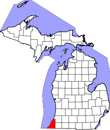 | |
| Villages | ||
| Charter townships | ||
| General law townships | ||
| CDPs | ||
| Other unincorporated communities | ||
| Footnotes | ‡This populated place also has portions in an adjacent county or counties | |