Kirkland, New York
| Kirkland, New York | |
|---|---|
| Town | |
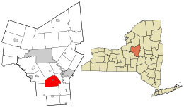 Location in Oneida County and the state of New York. | |
| Coordinates: 43°2′53″N 75°23′2″W / 43.04806°N 75.38389°WCoordinates: 43°2′53″N 75°23′2″W / 43.04806°N 75.38389°W | |
| Country | United States |
| State | New York |
| County | Oneida |
| Government | |
| • Type | Town Council |
| • Town Supervisor | Robert J. Meelan (D) |
| • Town Council |
Members' List
|
| Area | |
| • Total | 33.9 sq mi (87.7 km2) |
| • Land | 33.8 sq mi (87.5 km2) |
| • Water | 0.1 sq mi (0.2 km2) |
| Elevation | 689 ft (210 m) |
| Population (2010) | |
| • Total | 10,315 |
| • Density | 300/sq mi (120/km2) |
| Time zone | Eastern (EST) (UTC-5) |
| • Summer (DST) | EDT (UTC-4) |
| ZIP code | 13323 |
| Area code(s) | 315 |
| FIPS code | 36-39804 |
| GNIS feature ID | 0979120 |
Kirkland is a town in Oneida County, New York, United States. The population was 10,315 at the 2010 census. The town is named after Samuel Kirkland,[1] a missionary among the Oneidas.
The Town of Kirkland is southwest of Utica, New York. In 1829, part of Kirkland was used to form the newer Town of Marshall.
Hamilton College is in the western part of the town.
History
The first settlement occurred around 1787 near the present village of Clinton. The Town of Kirkland was established in 1827 from the Town of Paris. The land of the town belonged to the Kirkland Patent, Brothertown Patent, and Coxe Patent.
The Rev. Asahel Norton Homestead was listed on the National Register of Historic Places in 1985.[2]
Geography
According to the United States Census Bureau, the town has a total area of 33.9 square miles (88 km2), of which, 33.8 square miles (88 km2) of it is land and 0.1 square miles (0.26 km2) of it (0.21%) is water.
The Oriskany Creek flows through the town.
Demographics
| Historical population | |||
|---|---|---|---|
| Census | Pop. | %± | |
| 1830 | 2,509 | — | |
| 1840 | 2,984 | 18.9% | |
| 1850 | 3,421 | 14.6% | |
| 1860 | 4,185 | 22.3% | |
| 1870 | 4,912 | 17.4% | |
| 1880 | 4,984 | 1.5% | |
| 1890 | 4,852 | −2.6% | |
| 1900 | 4,545 | −6.3% | |
| 1910 | 4,333 | −4.7% | |
| 1920 | 4,744 | 9.5% | |
| 1930 | 5,059 | 6.6% | |
| 1940 | 5,211 | 3.0% | |
| 1950 | 6,164 | 18.3% | |
| 1960 | 7,978 | 29.4% | |
| 1970 | 9,688 | 21.4% | |
| 1980 | 10,334 | 6.7% | |
| 1990 | 10,153 | −1.8% | |
| 2000 | 10,138 | −0.1% | |
| 2010 | 10,315 | 1.7% | |
| Est. 2014 | 10,263 | [3] | −0.5% |
As of the census[5] of 2000, there were 10,138 people, 3,419 households, and 2,229 families residing in the town. The population density was 300.0 people per square mile (115.8/km²). There were 3,591 housing units at an average density of 106.3 per square mile (41.0/km²). The racial makeup of the town was 96.32% White, 1.20% African American, 0.07% Native American, 1.21% Asian, 0.03% Pacific Islander, 0.27% from other races, and 0.90% from two or more races. Hispanic or Latino of any race were 1.32% of the population.
There were 3,419 households out of which 30.4% had children under the age of 18 living with them, 53.1% were married couples living together, 8.9% had a female householder with no husband present, and 34.8% were non-families. 29.4% of all households were made up of individuals and 12.6% had someone living alone who was 65 years of age or older. The average household size was 2.39 and the average family size was 3.00.
In the town the population was spread out with 20.0% under the age of 18, 20.9% from 18 to 24, 21.2% from 25 to 44, 22.2% from 45 to 64, and 15.7% who were 65 years of age or older. The median age was 36 years. For every 100 females there were 91.4 males. For every 100 females age 18 and over, there were 86.8 males.
The median income for a household in the town was $45,875, and the median income for a family was $58,958. Males had a median income of $40,058 versus $27,265 for females. The per capita income for the town was $21,164. About 3.9% of families and 7.7% of the population were below the poverty line, including 9.6% of those under age 18 and 4.9% of those age 65 or over.
Communities and locations in Kirkland
- Chuckery Corners – A hamlet in the eastern part of the town on NY 12.
- Clark Mills – A hamlet in the northeast part of the town.
- Clinton – The Village of Clinton.
- Farmers Mills – A hamlet south of Clinton Village and Franklin Springs.
- Franklin Springs – A hamlet south of Clinton village. It was formerly the "Franklin Iron Works" during the iron smelting period of the town.
- Kirkland – A hamlet, formerly called "Manchester," near the west town line on NY 5.
References
- ↑ Gannett, Henry (1905). The Origin of Certain Place Names in the United States. Govt. Print. Off. p. 176.
- ↑ National Park Service (2009-03-13). "National Register Information System". National Register of Historic Places. National Park Service.
- ↑ "Annual Estimates of the Resident Population for Incorporated Places: April 1, 2010 to July 1, 2014". Retrieved June 4, 2015.
- ↑ "Census of Population and Housing". Census.gov. Retrieved June 4, 2015.
- ↑ "American FactFinder". United States Census Bureau. Retrieved 2008-01-31.
External links
Municipalities and communities of Oneida County, New York, United States | ||
|---|---|---|
| Cities | 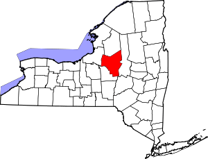 | |
| Towns | ||
| Villages | ||
| CDPs | ||
| Hamlets | ||