Imperial, Nebraska
| Imperial, Nebraska | |
|---|---|
| City | |
|
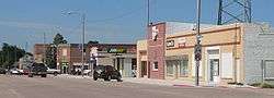
Downtown Imperial: Broadway, looking north | |
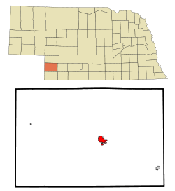 Location within Chase County and Nebraska | |
| Coordinates: 40°31′6″N 101°38′33″W / 40.51833°N 101.64250°WCoordinates: 40°31′6″N 101°38′33″W / 40.51833°N 101.64250°W | |
| Country | United States |
| State | Nebraska |
| County | Chase |
| Area[1] | |
| • Total | 2.95 sq mi (7.64 km2) |
| • Land | 2.95 sq mi (7.64 km2) |
| • Water | 0 sq mi (0 km2) |
| Elevation | 3,284 ft (1,001 m) |
| Population (2010)[2] | |
| • Total | 2,071 |
| • Estimate (2013[3]) | 2,091 |
| • Density | 700/sq mi (270/km2) |
| Time zone | Mountain (MST) (UTC-7) |
| • Summer (DST) | MDT (UTC-6) |
| ZIP code | 69033 |
| Area code(s) | 308 |
| FIPS code | 31-23690 |
| GNIS feature ID | 0830263 [4] |
| Website | imperial-ne.com |
Imperial is a city in Chase County, Nebraska, United States. The population was 2,071 at the 2010 census. It is the county seat of Chase County.[5]
History
The original town of Imperial was built on land homesteaded by Thomas Mercier and M.J. Goodrich. These men gave a town lot to anyone who would put up a building and help to start the town. Mercier was the first postmaster and took office on December 14, 1885.[6]
The railroad right of way was graded to Imperial in 1888. The railroad reached Imperial on August 15, 1892. It was built by a division of the Chicago, Burlington and Quincy Railroad. This line left the main line near Culbertson and terminated in Imperial.
When the grade was completed, the Lincoln Land Company gave lots to all those who would move their buildings to the "Railroad Addition". Nearly all of the buildings were moved south to the future railroad line and the present location of the business district of the town was established.
National Register of Historic Places listings
- Balcony House (listed 2000), at the corner of 10th and Court Streets. One block west of Broadway on 10th Street[7][8]
- Chase County Court House (listed 1990), on Broadway between 9th and 10th Streets [8][9]
Geography
Imperial is located at 40°31′6″N 101°38′33″W / 40.51833°N 101.64250°W (40.518398, -101.642491).[10] According to the United States Census Bureau, the city has a total area of 2.95 square miles (7.64 km2), all of it land.[1]
Climate
| Climate data for Imperial, Nebraska | |||||||||||||
|---|---|---|---|---|---|---|---|---|---|---|---|---|---|
| Month | Jan | Feb | Mar | Apr | May | Jun | Jul | Aug | Sep | Oct | Nov | Dec | Year |
| Record high °F (°C) | 68 (20) |
78 (26) |
86 (30) |
94 (34) |
99 (37) |
105 (41) |
110 (43) |
109 (43) |
103 (39) |
98 (37) |
82 (28) |
70 (21) |
110 (43) |
| Average high °F (°C) | 40 (4) |
44 (7) |
56 (13) |
65 (18) |
76 (24) |
88 (31) |
95 (35) |
92 (33) |
80 (27) |
65 (18) |
55 (13) |
44 (7) |
67 (19) |
| Average low °F (°C) | 12 (−11) |
16 (−9) |
26 (−3) |
37 (3) |
48 (9) |
58 (14) |
63 (17) |
61 (16) |
52 (11) |
35 (2) |
24 (−4) |
15 (−9) |
37 (3) |
| Record low °F (°C) | −33 (−36) |
−27 (−33) |
−21 (−29) |
11 (−12) |
19 (−7) |
33 (1) |
40 (4) |
39 (4) |
31 (−1) |
15 (−9) |
−9 (−23) |
−29 (−34) |
−33 (−36) |
| Average precipitation inches (mm) | 0.51 (13) |
0.44 (11.2) |
0.79 (20.1) |
2.56 (65) |
5.22 (132.6) |
4.67 (118.6) |
2.60 (66) |
3.15 (80) |
3.09 (78.5) |
1.02 (25.9) |
0.56 (14.2) |
0.28 (7.1) |
24.89 (632.2) |
| Average snowfall inches (cm) | 12 (30) |
9.6 (24.4) |
7.2 (18.3) |
1 (3) |
0 (0) |
0 (0) |
0 (0) |
0 (0) |
0 (0) |
0.7 (1.8) |
6.8 (17.3) |
15 (38) |
52.3 (132.8) |
| Source: [11] | |||||||||||||
Demographics
| Historical population | |||
|---|---|---|---|
| Census | Pop. | %± | |
| 1890 | 159 | — | |
| 1900 | 258 | 62.3% | |
| 1910 | 402 | 55.8% | |
| 1920 | 723 | 79.9% | |
| 1930 | 946 | 30.8% | |
| 1940 | 1,195 | 26.3% | |
| 1950 | 1,563 | 30.8% | |
| 1960 | 1,423 | −9.0% | |
| 1970 | 1,589 | 11.7% | |
| 1980 | 1,941 | 22.2% | |
| 1990 | 2,007 | 3.4% | |
| 2000 | 1,982 | −1.2% | |
| 2010 | 2,071 | 4.5% | |
| Est. 2015 | 2,056 | [12] | −0.7% |
| U.S. Decennial Census[13] 2013 Estimate[3] | |||
2010 census
As of the census[2] of 2010, there were 2,071 people, 860 households, and 553 families residing in the city. The population density was 702.0 inhabitants per square mile (271.0/km2). There were 948 housing units at an average density of 321.4 per square mile (124.1/km2). The racial makeup of the city was 88.3% White, 0.1% Native American, 0.1% Asian, 9.6% from other races, and 1.9% from two or more races. Hispanic or Latino of any race were 15.4% of the population.
There were 860 households of which 30.3% had children under the age of 18 living with them, 52.0% were married couples living together, 8.1% had a female householder with no husband present, 4.2% had a male householder with no wife present, and 35.7% were non-families. 31.4% of all households were made up of individuals and 16% had someone living alone who was 65 years of age or older. The average household size was 2.37 and the average family size was 2.97.
The median age in the city was 41 years. 25.2% of residents were under the age of 18; 7.3% were between the ages of 18 and 24; 22.4% were from 25 to 44; 26% were from 45 to 64; and 19.2% were 65 years of age or older. The gender makeup of the city was 48.9% male and 51.1% female.
2000 census
As of the census of 2000, there were 1,982 people, 807 households, and 547 families residing in the city. The population density was 787.2 people per square mile (303.7/km²). There were 887 housing units at an average density of 352.3 per square mile (135.9/km²). The racial makeup of the city was 97.88% White, 0.05% African American, 0.10% Native American, 0.15% Asian, 1.61% from other races, and 0.20% from two or more races. Hispanic or Latino of any race were 5.15% of the population.
There were 807 households out of which 32.1% had children under the age of 18 living with them, 57.9% were married couples living together, 6.9% had a female householder with no husband present, and 32.2% were non-families. 29.6% of all households were made up of individuals and 16.1% had someone living alone who was 65 years of age or older. The average household size was 2.38 and the average family size was 2.94.
In the city the population was spread out with 26.0% under the age of 18, 6.6% from 18 to 24, 24.1% from 25 to 44, 21.6% from 45 to 64, and 21.6% who were 65 years of age or older. The median age was 41 years. For every 100 females there were 93.4 males. For every 100 females age 18 and over, there were 89.2 males.
As of 2000 the median income for a household in the city was $33,833, and the median income for a family was $42,414. Males had a median income of $28,063 versus $19,405 for females. The per capita income for the city was $19,888. About 5.7% of families and 7.7% of the population were below the poverty line, including 5.0% of those under age 18 and 9.6% of those age 65 or over.
Notable people
- Todd Burpo, co-author of the book Heaven is for Real.[14]
- Warren Prall Watters, founding archbishop of the Free Church of Antioch, was born in Imperial.
References
- 1 2 "US Gazetteer files 2010". United States Census Bureau. Archived from the original on January 24, 2012. Retrieved 2012-06-24.
- 1 2 "American FactFinder". United States Census Bureau. Retrieved 2012-06-24.
- 1 2 "Population Estimates". United States Census Bureau. Retrieved 2014-07-17.
- ↑ "US Board on Geographic Names". United States Geological Survey. 2007-10-25. Retrieved 2008-01-31.
- ↑ "Find a County". National Association of Counties. Archived from the original on May 31, 2011. Retrieved 2011-06-07.
- ↑ "Imperial, Chase County". Center for Advanced Land Management Information Technologies. University of Nebraska. Retrieved 2 August 2014.
- ↑ Chase County Tourism
- 1 2 Nebraska State Historical Society
- ↑ Chase County Tourism
- ↑ "US Gazetteer files: 2010, 2000, and 1990". United States Census Bureau. 2011-02-12. Retrieved 2011-04-23.
- ↑ http://www.intellicast.com
- ↑ "Annual Estimates of the Resident Population for Incorporated Places: April 1, 2010 to July 1, 2015". Retrieved July 2, 2016.
- ↑ United States Census Bureau. "Census of Population and Housing". Archived from the original on May 11, 2015. Retrieved October 18, 2013.
- ↑ Schultz, Jan. "Burpo’s book makes Times Best Seller List". Imperial Republican. No date for article given on website. Retrieved 2011-02-27.
External links
| Wikimedia Commons has media related to Imperial, Nebraska. |
Municipalities and communities of Chase County, Nebraska, United States | ||
|---|---|---|
| City | ||
| Villages | ||
| CDPs | ||