Colfax County, Nebraska
| Colfax County, Nebraska | |
|---|---|
_from_NE_1.JPG) Colfax County Courthouse in Schuyler | |
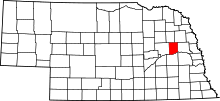 Location in the U.S. state of Nebraska | |
 Nebraska's location in the U.S. | |
| Founded | 1869 |
| Named for | Schuyler Colfax |
| Seat | Schuyler |
| Largest city | Schuyler |
| Area | |
| • Total | 417 sq mi (1,080 km2) |
| • Land | 412 sq mi (1,067 km2) |
| • Water | 4.9 sq mi (13 km2), 1.2% |
| Population | |
| • (2010) | 10,515 |
| • Density | 26/sq mi (10/km²) |
| Congressional district | 1st |
| Time zone | Central: UTC-6/-5 |
| Website |
www |

Colfax County is a county in the U.S. state of Nebraska. As of the 2010 census, the population was 10,515.[1] Its county seat is Schuyler.[2] The county and its seat are named after former Vice President of the United States, Schuyler Colfax.[3]
In the Nebraska license plate system, Colfax County is represented by the prefix 43 (it had the 43rd largest number of vehicles registered in the county when the license plate system was established in 1922).
History
Colfax County's first courthouse was completed in 1872.[4]
Geography
According to the U.S. Census Bureau, the county has an area of 417 square miles (1,080 km2), of which 412 square miles (1,070 km2) is land and 4.9 square miles (13 km2) (1.2%) is water.[5]
Major highways
Adjacent counties
- Dodge County (east)
- Butler County (south)
- Platte County (west)
- Stanton County (north)
- Cuming County (northeast)
Demographics
| Historical population | |||
|---|---|---|---|
| Census | Pop. | %± | |
| 1870 | 1,424 | — | |
| 1880 | 6,588 | 362.6% | |
| 1890 | 10,453 | 58.7% | |
| 1900 | 11,211 | 7.3% | |
| 1910 | 11,610 | 3.6% | |
| 1920 | 11,624 | 0.1% | |
| 1930 | 11,434 | −1.6% | |
| 1940 | 10,627 | −7.1% | |
| 1950 | 10,010 | −5.8% | |
| 1960 | 9,595 | −4.1% | |
| 1970 | 9,498 | −1.0% | |
| 1980 | 9,890 | 4.1% | |
| 1990 | 9,139 | −7.6% | |
| 2000 | 10,441 | 14.2% | |
| 2010 | 10,515 | 0.7% | |
| Est. 2015 | 10,520 | [6] | 0.0% |
| U.S. Decennial Census[7] 1790-1960[8] 1900-1990[9] 1990-2000[10] 2010-2013[1] | |||
As of the census[11] of 2000, there were 10,441 people, 3,682 households, and 2,592 families residing in the county. The population density was 25 people per square mile (10/km²). There were 4,088 housing units at an average density of 10 per square mile (4/km²). The racial makeup of the county was 81.73% White, 0.07% Black or African American, 0.19% Native American, 0.20% Asian, 0.14% Pacific Islander, 15.94% from other races, and 1.73% from two or more races. 26.17% of the population were Hispanic or Latino of any race. 28.8% were of German and 24.2% Czech ancestry according to Census 2000.
There were 3,682 households out of which 35.60% had children under the age of 18 living with them, 58.90% were married couples living together, 7.10% had a female householder with no husband present, and 29.60% were non-families. 25.70% of all households were made up of individuals and 15.40% had someone living alone who was 65 years of age or older. The average household size was 2.80 and the average family size was 3.31.
In the county the population was spread out with 28.90% under the age of 18, 8.50% from 18 to 24, 27.90% from 25 to 44, 18.70% from 45 to 64, and 16.00% who were 65 years of age or older. The median age was 35 years. For every 100 females there were 106.40 males. For every 100 females age 18 and over, there were 105.70 males.
The median income for a household in the county was $35,849, and the median income for a family was $40,936. Males had a median income of $25,656 versus $20,485 for females. The per capita income for the county was $15,148. About 7.20% of families and 10.80% of the population were below the poverty line, including 13.80% of those under age 18 and 7.90% of those age 65 or over.
Communities
See also
References
- 1 2 "State & County QuickFacts". United States Census Bureau. Retrieved September 17, 2013.
- ↑ "Find a County". National Association of Counties. Archived from the original on 2011-05-31. Retrieved 2011-06-07.
- ↑ Bain, David Haward (2004). The Old Iron Road: An Epic of Rails, Roads, and the Urge to Go West. New York City, New York: Penguin Books. pp. 65–6. ISBN 0-14-303526-6.
- ↑ Maas, Mary L.; Krycki, Jim; Brezina, Judy; Walters, Ruth (2014). Colfax County. Arcadia Publishing. p. 21.
- ↑ "2010 Census Gazetteer Files". United States Census Bureau. August 22, 2012. Retrieved December 6, 2014.
- ↑ "County Totals Dataset: Population, Population Change and Estimated Components of Population Change: April 1, 2010 to July 1, 2015". Retrieved July 2, 2016.
- ↑ "U.S. Decennial Census". United States Census Bureau. Archived from the original on May 11, 2015. Retrieved December 6, 2014.
- ↑ "Historical Census Browser". University of Virginia Library. Retrieved December 6, 2014.
- ↑ "Population of Counties by Decennial Census: 1900 to 1990". United States Census Bureau. Retrieved December 6, 2014.
- ↑ "Census 2000 PHC-T-4. Ranking Tables for Counties: 1990 and 2000" (PDF). United States Census Bureau. Retrieved December 6, 2014.
- ↑ "American FactFinder". United States Census Bureau. Archived from the original on 2013-09-11. Retrieved 2008-01-31.
 |
Stanton County | Cuming County | | |
| Platte County | |
Dodge County | ||
| ||||
| | ||||
| Butler County |
Municipalities and communities of Colfax County, Nebraska, United States | ||
|---|---|---|
| Cities | ||
| Villages | ||
| Unincorporated communities | ||
Coordinates: 41°35′N 97°05′W / 41.58°N 97.09°W