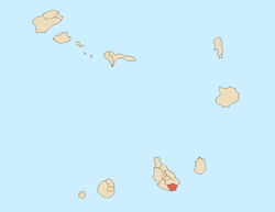
Ilhéu de Santa Maria
.jpg) | |
 | |
| Geography | |
|---|---|
| Location | Atlantic Ocean |
| Coordinates | 14°54′27″N 23°30′26″W / 14.90750°N 23.50722°W |
| Archipelago | Cape Verde |
| Area | 0.05 km2 (0.019 sq mi) |
| Length | 0.42 km (0.261 mi) |
| Width | 0.13 km (0.081 mi) |
| Highest elevation | 6 m (20 ft) |
| Administration | |
|
Cape Verde | |
| Concelhos (Municipalities) | Praia |
Ilhéu de Santa Maria, once known as Quail Island is a small uninhabited tiny islet of the Sotavento archipelago in Cape Verde located south of the Santiago. Like all Cape Verdean islands, the islet is of volcanic origin. The islet has an area of roughly 0.05 km2 and is 420 meters long and 130 meters wide, it is situated in front of Praia da Gamboa and forms a part of the city of Praia since 1975, it is due south of the city center and is inside the harbor. Until the early 2010s, it was separated by about 120 m from the beach, not it separates nearly 250 meters from the beach.
History
_p0166_CAPE_VERDE%2C_PORTO_PRAYA.jpg)
.jpg)
Until about 4,000 to 2,000 BC (as late as 1,000 BC), the area was part of Santiago Island and it used to be a hill and was a surrounded by a southeastern and a southern hill that had now disappeared, it became an islet as the sea level rose after the Late Ice Age.
The island was used as a leper colony. Surrounded by water of the Atlantic, it can be accessible by a boat or by foot during low tide.
The Battle of Porto Praya (now Praia) took place on 16 April 1781 at the harbor northeast of the island, one British ship was just about 200 feet (70 meters) from the islet, a second one was a little distant and next were three British convoys. About 800 feet (250 meters) east of the southern tip was the French ship Artésien and very close was a British convoy.
The island was visited by Charles Darwin, a great figure in world science, in his famous circumnavigational voyage on board the HMS Beagle, he made his first geologic observations in 1832. After he left England, he visited Praia and the Beagle landed for the first time.
Its observations were published in his work "Geological Observations on the Volcanic Islands During the Voyage of the H.M.S. Beagle". Since the times of Charles Darwin, different publications of the scientific studies on the geology of the islet were made.
In the mid-1850s, six spacious houses were built in 30 hours and housed individuals who had cholera from the island of Fogo intermitted there, its buildings located in the north of the islet are left in ruins.
In the late-19th century, a coal wharf was established in the western part and featured two coaling platforms built predominantly by the Portuguese and the British for supplying and refueling ships mainly bounded for the Americas and Australia. The island also featured a flagstaff
Ponta do Visconde on Santiago Island, once 2 km to the east, as the port expanded between around 2009 and 2014 now is about 1 km to the east which almost split Praia Harbour in two, also it became the third southernmost point of the area of Santiago Island and its surroundings but remains the second natural southernmost feature.
In 2015, the Cape Verdean government and Legend Development Company made a legal contract and proposes to construct hotel resort and casino, it was published in a Cape Verdean official bulletin Expresso das Ilhas, its cost is around 30 billion Cape Verdean escudos (250 million euros).[1] It will probably be connected with road running over a bridge or a partial sea barrier and intersecting the road with the roundabout.
Notes
- ↑ "Hotel-Casino no Ilhéu de Santa Maria: Governo concessiona Djeu por 75 anos" [Hotel-Casino in Ilhéu de Santa Maria: Government Concession of the Islet (Djeu) for 75 Years]. Expresso das Ilhas (in Portuguese). 2015.
Further reading
- Geological observations on the volcanic islands visited during the voyage of H.M.S. Beagle. (1844), text is available at Darwin Online
| Wikimedia Commons has media related to Ilhéu de Santa Maria. |
| Island groups | ||
|---|---|---|
| Islands | ||
| Islets | ||
| Neighbourhoods |
|   |
|---|---|---|
| Geographical features | ||
| Major squares | ||
| Major streets and arterials |
| |
| Universities and educational institutions |
| |
| Landmarks and tourism | ||
| Sports facilities and complexes | ||
| Transportation | ||
| Culture |
| |
| History (Timeline) | ||