Ribeira da Trindade
| Ribeira da Trindade | |
|---|---|
| Country | Cape Verde |
| Basin | |
| Main source |
southwest of São Domingos Santiago Island, Cape Verde 650 m (2,130 ft) |
| River mouth |
Praia Harbor, Atlantic Ocean 14°54′59″N 22°30′27″W / 14.9165°N 22.5074°WCoordinates: 14°54′59″N 22°30′27″W / 14.9165°N 22.5074°W |
| Physical characteristics | |
| Length | 15 km (9.3 mi) |
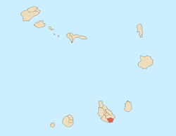
Ribeira da Trindade (Portuguese for trinity) is a stream that flows in the southeastern part of the island of Santo Antão in Cape Verde. It is Praia's longest stream and it has a large basin area covering about 44 km² (around 4%) making it one of the largest on the island. The stream mainly flows northwest to southeast and is about 14 to 15 km in length. It flows in the area of Achadinha (a hamlet southwest of São Domingos and southeast of Rui Vaz and is also southeast of the boundaries of Pico da Antónia Natural Park) all the way to the center of Praia between the Platô and Achada Grande Frente and empties at its harbor. During dry days especially in the Spring and Summer, the stream is predominantly dry.
Geography
.jpg)
.jpg)
The stream strats from the agricultural and mountainous portion of the south of the island. It passes through the municipal boundary at 350 meters above sea level then into the settlement of Trindade in which the stream gives the name to, the elevation being 175 meters. In that area features a chapel of the Trinity, it also features a baobab tree, a psychiatric hospital and a warehouse center named São Martinho. Close by is the locality named Vera Cruz, between 2007 and 2016, the population and the built up area have doubled. It crosses the road at 103 meters, the Circular Road at 99 meters, 53 meters at the tributary with Ribeira de São Jorge, 50 meters the tributary with Ribeira da Veneza, 43 meters at Pensamento, 29 meters by Calabaceira and its football (soccer) field, 22 meters at the tributary with Ribeira de Safende and Vila Nova, 20 meters at the Praia-Tarrafal highway (EN1-ST01), 14 meters at Lem Cachorro and its pedestrian bridge below, 12 meters at Rua do Aeroporto (EN1-ST06) ans 5 meters east of the SCCR factory.
The neighborhood boundaries are marked on the south bank, one of them being Achadinha de Baixo, some of the boundary are marked at some streets.
History
During the Ice Age, the stream was 3.5 kilometers longer and was 18 km and emptied 1.6 km southeast of Ponta Temerosa, it shortened to 16 km some 8,000 to 7,000 years ago.
Before the 17th century, the he low lying areas were forested, they were cut down to make room for farming and agriculture, the forest stretched up to Ribeira Grande, the upper part of the landscape before the 17th century is unknown.
Built up areas dominated the lower part of the stream in the 1990s and fully in the early 2010s. In the 2010s, most of the areas within the stream have became partly forested.
In 2005, a French fishing boat sunk very close to the mouth of Ribeira da Trindade on the boundary with Achada Grande to the east. A few years later in that area, the new location of Sociedade Cabo-verdiana de Cerveja e Refrigerantes (SCCR),[1] the Cape Verdean major beverage company started construction of its factory in 2008 and was completed in 2009.
Tributaries
- Ribeira da Trindade - lesser stream - 2 km
- Ribeira de São Jorge - begins at the hamlet of Figueira Portugal Antiga passes through São Jorge
- Ribeira Veneza - begins in the area of Fontes Acima and passes through the village of Veneza and its east-west municipal boundary some 200 meters south (then unmarcated)
- Ribeira Venteiro - two streams
- Ribeira Forno - begins in the area of Forno
- Riberinha - in the area of the hamlet of João Bom
- Ribeira de Safende - starts in the area of Safende
- Ribeira de São Filipe - passes through Achada de São Filipe which gives its name to a neighborhood and empties south of Paiol alongside Água Funda
- Ribeira do Água Funda - starts south the Circular Road, passes through Covão Mendes and empites south of Paiol alongside São Filipe
See also
References
- ↑ "Nova era para a (antiga) Ceris" [New Era for the (Old) CERIS]. A Semana (in Portuguese). 14 November 2006. Retrieved 10 November 2016.
Geography, features and topics of Santiago and the surrounding islets | ||
|---|---|---|
| Topics | 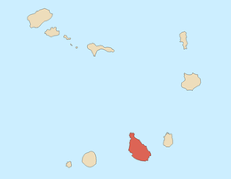 | |
| Mountains | ||
| Streams |
| |
| Points and promontories |
| |
| Reservoirs |
| |
| Other geographic features | ||
| History | ||
| Neighbourhoods |
|   |
|---|---|---|
| Geographical features | ||
| Major squares | ||
| Major streets and arterials |
| |
| Universities and educational institutions |
| |
| Landmarks and tourism | ||
| Sports facilities and complexes | ||
| Transportation | ||
| Culture |
| |
| History | ||