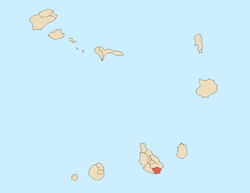
Praia Harbor
.jpg)
Praia Harbor or Porto da Praia is the city's harbor located southeast of Praia and south of the island of Santiago, Cape Verde. Its length is 8.6 km stretching from the points of Temerosa through Ribeira da Trindade northwet up to Bicudas. It is now divided into two parts since 2013, the western part is 5 km long stretching up to Ponta do Porto (formerly Ponta de Visconde) and 3 km east to Ponta das Bicudas. Its length is 2.82 km and its width is 1.67 km, the western width is 1.1 km and its eastern length is 1.5 km and the width is around 600 meters. From the islet to Ponta do Porto is only less than 490 meters and 2.4 km up to Ponta das Bicudas. In the middle is the Port of Praia, the island and country's chief port.
The harbor are surrounded by the city's subdivisions including Prainha-Temerosa, Gamboa, the Platô in the west and Achada Grande to the east with the subdivisions of Leite and Tras. Four beaches includes Prainha, Gamboa (once called Santa Maria), Negra and Bicudas, the three are very small and Gamboa is its largest. Ribeira da Trindade is the largest stream emptying into the barbar at the middle near the center, a tiny stream is in the west and two streams starting in Achada Grande Tras are in the eastern part.
Numerous streets runs within the harbor including Avenida Rotary International in Prainha, Avenida de Cuba and Rua de Combatadoresde Liberatadores da Praia in Gamboa and the Plateau and Avenida Charles Darwin in the north.
History

_p098_PORTO_PRAYA%2C_ISLAND_OF_ST.JAGO.jpg)
_p0166_CAPE_VERDE%2C_PORTO_PRAYA.jpg)
Before 6000 BC, the harbor or the cove was very small as the sea level was lower during the Ice Age, the previous shoreline is unknown. Around 3000 BC, the islet was formed after splitting from the mainland at Praia and formed what is now Ilhéu de Santa Maria and enlarged the harbor.
Together with the island, the harbor was discovered in 1460 by explorer António da Noli and possibly one of the first portion of the island to be discovered.
Early in the 16th century, the low-lying areas surrounding the harbor were forested with kapok trees, they were cut down to make room for farming and agriculture, the forest stretched up to the area west of Praia. Later some portions of the forest were restored mainly with palm in the 18th century and the remainder restored with kapok trees and intermingled with buildings and landmarks built in the 1930s and the mid 20th century, a dense palm grove as they were in the mid-20th century no longer exist, since 2011, the entire harbor is a built up area with the exception of the area of Ponta das Bicudas.
In the 16th century, the small settlement was founded and was named Praia de Santa Maria (now Gamboa), later in 1612, another settlement was founded. It became a settlement, later town that would serve as a harbor, in the mid 19th century, Praia became a city.
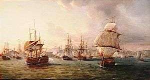
Praia was raided for the only time in 1585 during the Capture of Santiago, his ships were stationed at the harbor and landed on the beach.[1] After the Cassard expedition, the island capital was moved to Praia and several cannons were installed in the east of Plateau facing the harbour, one of them at the battery and barracks today known as Quartel Jaime Mota. The Battle of Porto Praya took place on April 16, 1781, part of the Anglo-French War of 1778-83 took place inside the harbor. Before the battle on 13 March 1781 Johnstone sailed from Spithead, England with a fleet of 37 ships, including five ships of the line, three frigates, and a large number of troop convoy ships. In early April the fleet anchored in the neutral harbour of Porto Praya in the Portuguese-controlled Cape Verde Islands to take on water and supplies. One of Suffren's ships, the Artésien, had originally been destined for America, and was in need of water, so the French fleet paused when it approached Santiago on 16 April, and Suffren ordered the Artésien to the harbour. The battle took part with Great Britain and France and began and later, the French won the battle, for a day the waters were either British or French.[2]
At the islet, a coal wharf was founded for refueling coal powered ships in the mid 19th century which lasted to the 1950s. In 1881 between the harbor and the rest of the Atlantic, the Farol de D. Maria Pia was built, it is now known as Farol de Ponta Temerosa.
Before 1960, the harbor had a long pier at Gamboa, it also had another wooden pier and a mole by the Plateau. By the harbor had a customs house which is now the Capeverdean National Archives Building.[3] As Gamboa beach was enlarged with additional sands, the Port of Praia moved to the area of Ponta de VIsconde 1 kilometer east in the 1960s and started to offer ferry service with other Cape Verdean islands and port activity primarily imports into Cape Verde. The point was enlarged by 700 meters. Gamboa's sands now extended 100 meters into the harbor covering most of the old pier, another pier would be built.
In the same time, the urban area was getting larger, in the 1940s, the built up area reached Gamboa, from around 1960 to 1980, the urban sprawl headed all the way to Ponta Temerosa adding the islet to it, in around 1970, the urban sprawl reached Achada Grande Leite and Praia's Refinery, that part of the harbor up to Ponta das Bicudas consisted of open space, industrial buildings began to appear in 2012 and around the promontory is now in a process of being a fully built up/greenspace area.
In 2002, Rua de Combatadores de Liberatores da Patria went under construction and finished in 2003, it was the extension of what was Rua do Porto and encircles the west of the harbor, two rotaries exists in the northern part, before there was never a road in the area between the plateau and the river.
Three recent shipwrecks occurred at the front of the mouth of Ribeira da Trindade, first in around the 1990s, then a second one in around 2004 and a third one in 2005, a French fishing boat sunk very close to the on the boundary with Achada Grande to the east, the weather and sea conditions made the boat rusty and in 2014, its remains disappeared. The right one disappeared in 2007 and the left one disappeared in 2010 and only a tiny remain is left.
In 2012, the port underwent another expansion and was finished in late 2013, it quadrupled it size with additional cargo space, the point moved 400 meters south and is now south of the islet, its length and width are larger that the largest islet within Santiago along with its size.
Panoramics

It is one part of the city that offers beautiful panoramics including the southern part, at Prainha and Gamboa, it offers a view of Praia and Achada Grande and in the east offers the view of the west of Praia along with Monte Vermelho and the south of the island.
References
- ↑ Sugden 185-86
- ↑ Theal (1897), p.181.
- ↑ "Cape Verdean National Archives, the ANCV" (in Portuguese). Casa do Comunes.
Bibliography
| Wikimedia Commons has media related to Port of Praia. |
- Sugden, John (2004). Sir Francis Drake. Penguin Books. ISBN 978-1844137626.
- Theal, George McCall (1897) History of South Africa under the administration of the Dutch East India Company, 1652 to 1795. (S. Sonnenschein & co., Ptd.).
| Neighbourhoods |
|   |
|---|---|---|
| Geographical features | ||
| Major squares | ||
| Major streets and arterials |
| |
| Universities and educational institutions |
| |
| Landmarks and tourism | ||
| Sports facilities and complexes | ||
| Transportation | ||
| Culture |
| |
| History | ||
Geography, features and topics of Santiago and the surrounding islets | ||
|---|---|---|
| Topics | 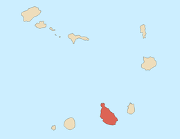 | |
| Mountains | ||
| Streams |
| |
| Points and promontories |
| |
| Reservoirs |
| |
| Other geographic features | ||
| History | ||
Coordinates: 14°55′12″N 23°30′26″W / 14.9199°N 23.5071°W