Ilhéu Raso
| Native name: <span class="nickname" ">Ilhéu Razu | |
|---|---|
|
Raso landscape | |
 | |
| Geography | |
| Location | Atlantic Ocean |
| Coordinates | 16°37′0″N 24°35′57″W / 16.61667°N 24.59917°W |
| Archipelago | Cape Verde |
| Area | 7 km2 (2.7 sq mi) |
| Length | 3 km (1.9 mi) |
| Width | 2.4 km (1.49 mi) |
| Highest elevation | 395 m (1,296 ft) |
| Administration | |
|
Cape Verde | |
| Concelhos (Municipalities) | São Vicente |


Raso is an uninhabited 7 square kilometres (2.7 square miles)[1] volcanic island in the Barlavento archipelago of Cape Verde. Razo is an old name for the island. It is flanked by the smaller Branco islet to the west and by São Nicolau island on its eastern side, distance is 15 kilometres (9.3 miles) from the island of São Nicolau.
Environment
The island is a stratovolcano some 3 kilometres (1.9 miles) long by 2.4 kilometres (1.5 miles) wide, reaching a height of 164 metres (538 feet) above sea level. It is approximately 123 million years old and was formed from even older oceanic crust.[2] The south-western part is a dry, boulder-strewn plain. There is little vegetation apart from an area of grassland in the south-west. The entire coastline consists of rocky cliffs.[3] Along with nearby Santa Luzia and Ilhéu Branco, it was declared a protected area in 1990.[4]
Flora
The island's flora includes Limonium brunneri
Fauna
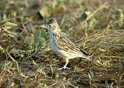
Raso is now the only home of the critically endangered Raso lark (about 45 pairs). The island has been identified as an Important Bird Area (IBA) by BirdLife International because, as well as the larks, it supports populations of Cape Verde shearwaters (with an estimated 2500–3750 breeding pairs), red-billed tropicbirds (25–40 pairs), Cape Verde (or Cape Verdean) owl and Iago sparrows, other includes Oceanodroma castro.[3] It is one of only two islands where the possibly extinct Cape Verde giant skink has been recorded. The Cape Verde giant gecko (Tarentola gigas) and a skink (Mabuya stangeri) still occur.[5]
Climate
Most of the year are predominantly dry, rainfalls occurs in August and last up to November. Temperatures on the mountain are around 20 °C (68 °F).
World Heritage Site elevation plans
A plan to make the nature reserve together with the two eastern islets as a World Heritage Site began as a nomination, one of eight in the tentative list. No plans have been made.
References
- ↑ Tosco, Rubén Baroné (January 2005). Las aves endémicas de las islas de Cabo Verde [Endemic Birds in the Cape Verde Islands]. VieiraYClavijo.org (in Spanish).
- ↑ Muller, R., Sdrolias, M., & Roest, W.: Age, spreading rates and spreading symmetry of the world’s ocean crust. In: Geochemistry Geophysics Geosystems. 9(Q04006), 2008, S. 1525-2027.
- 1 2 "Ilhéu Raso". Important Bird Areas factsheet. BirdLife International. 2013. Retrieved 2013-08-07.
- ↑ "Protected areas of Cape Verde" (in Portuguese).
- ↑ Miralles, A. u. a.: An integrative taxonomic revision of the Cape Verdean skinks (Squamata, Scincidae). In: Zoologica Scripta. 2010.
External links
| Wikimedia Commons has media related to Ilhéu Raso. |
- Fauna and flora of Cape Verde
- Ilhéu Raso (BirdLife International)
- « Étude de cas : Ilhéu Raso » (Biosfera I) (French)
| Island groups | ||
|---|---|---|
| Islands | ||
| Islets | ||
Coordinates: 16°37′N 24°35′W / 16.617°N 24.583°W