Hollister, California
| City of Hollister | |
|---|---|
| City | |
|
Hollister's City Hall | |
 Location in San Benito County and the state of California | |
 City of Hollister Location in the United States | |
| Coordinates: 36°51′09″N 121°24′06″W / 36.85250°N 121.40167°WCoordinates: 36°51′09″N 121°24′06″W / 36.85250°N 121.40167°W | |
| Country | United States |
| State | California |
| County | San Benito |
| Incorporated | March 26, 1872[1] |
| Area[2] | |
| • Total | 7.290 sq mi (18.880 km2) |
| • Land | 7.290 sq mi (18.880 km2) |
| • Water | 0 sq mi (0 km2) 0% |
| Elevation[3] | 289 ft (88 m) |
| Population (April 1, 2010)[4] | |
| • Total | 34,928 |
| • Estimate (2013)[4] | 36,589 |
| • Density | 4,800/sq mi (1,900/km2) |
| Time zone | Pacific (PST) (UTC−8) |
| • Summer (DST) | PDT (UTC−7) |
| ZIP codes | 95023, 95024 |
| Area code(s) | 831 |
| FIPS code | 06-34120 |
| GNIS feature IDs | 1658766, 2410778 |
| Website |
www |

Hollister is a city in and the county seat of San Benito County, California, United States. The population was 34,928 at the 2010 census. Hollister is primarily an agricultural town.
History
The Mutsun Ohlone Indians were the first known inhabitants of the Hollister region.
The town, then located in Monterey County, was founded November 19, 1868 when the San Justo Homestead Association purchased the property from William Welles Hollister (1818–1886). Undecided about a name for the new town, an association member, Napa vintner Henry Hagen, was tired of Saint and Spanish names in nearby towns and suggested the name Hollister. The City was incorporated on August 29, 1872. The western portion of San Benito County, including Hollister, was separated from Monterey County in 1874. The county was expanded eastward in 1887 to include portions taken from Merced and Fresno Counties.

Geology

Hollister is well-known among geologists because it portrays one of the best examples of aseismic creep anywhere in the world. The Calaveras Fault (a branch of the San Andreas Fault system) bisects the city north and south, roughly along Locust Ave. and Powell St. The streets running east/west across the fault have significant visible offsets. The fault runs directly under several houses. Even though they are visibly contorted the houses are still habitable as the owners have reinforced them to withstand the dislocation of their foundations. Although there was extensive damage in the town after the 1989 Loma Prieta earthquake, and the governor of California came to visit, this was due to a slip of the San Andreas Fault and was not related to the aseismic creep on the Calaveras Fault.
Hollister is one of at least three California towns to claim the title of "Earthquake Capital of the World" the other two being Coalinga and Parkfield.[5]
Climate
Hollister has a warm-summer mediterranean climate (Köppen csb) that has warmer summers than the Monterey–Salinas area but also being cooler than many other inland cities of the central part of the state. Despite this, daytime temperatures of 80 °F (27 °C) or warmer are commonplace between June and October, but hot extremes can be much more severe.
| Climate data for Hollister, California (1948-2015 normals) | |||||||||||||
|---|---|---|---|---|---|---|---|---|---|---|---|---|---|
| Month | Jan | Feb | Mar | Apr | May | Jun | Jul | Aug | Sep | Oct | Nov | Dec | Year |
| Record high °F (°C) | 84 (29) |
82 (28) |
89 (32) |
99 (37) |
105 (41) |
108 (42) |
112 (44) |
110 (43) |
105 (41) |
107 (42) |
94 (34) |
78 (26) |
112 (44) |
| Average high °F (°C) | 60.2 (15.7) |
62.6 (17) |
65.9 (18.8) |
69.9 (21.1) |
73.8 (23.2) |
78.1 (25.6) |
80.5 (26.9) |
81.2 (27.3) |
81.0 (27.2) |
76.5 (24.7) |
66.8 (19.3) |
60.0 (15.6) |
71.4 (21.9) |
| Average low °F (°C) | 38.0 (3.3) |
40.7 (4.8) |
42.5 (5.8) |
44.3 (6.8) |
47.7 (8.7) |
50.9 (10.5) |
53.1 (11.7) |
53.4 (11.9) |
52.3 (11.3) |
47.8 (8.8) |
41.6 (5.3) |
37.3 (2.9) |
45.8 (7.7) |
| Record low °F (°C) | 20 (−7) |
20 (−7) |
25 (−4) |
27 (−3) |
37 (3) |
38 (3) |
44 (7) |
45 (7) |
40 (4) |
34 (1) |
24 (−4) |
14 (−10) |
14 (−10) |
| Average rainfall inches (mm) | 2.78 (70.6) |
2.75 (69.9) |
2.15 (54.6) |
1.01 (25.7) |
0.35 (8.9) |
0.06 (1.5) |
0.03 (0.8) |
0.05 (1.3) |
0.29 (7.4) |
0.70 (17.8) |
1.62 (41.1) |
2.06 (52.3) |
13.85 (351.9) |
| Average rainy days (≥ 0.01 in) | 8.8 | 8.9 | 8.3 | 4.8 | 2.2 | 0.6 | 0.1 | 0.2 | 0.9 | 2.8 | 5.5 | 7.7 | 50.8 |
| Source: [6] | |||||||||||||
Demographics
| Historical population | |||
|---|---|---|---|
| Census | Pop. | %± | |
| 1880 | 1,034 | — | |
| 1890 | 1,234 | 19.3% | |
| 1900 | 1,315 | 6.6% | |
| 1910 | 2,308 | 75.5% | |
| 1920 | 2,781 | 20.5% | |
| 1930 | 3,757 | 35.1% | |
| 1940 | 3,881 | 3.3% | |
| 1950 | 4,903 | 26.3% | |
| 1960 | 6,071 | 23.8% | |
| 1970 | 7,663 | 26.2% | |
| 1980 | 11,488 | 49.9% | |
| 1990 | 19,212 | 67.2% | |
| 2000 | 34,413 | 79.1% | |
| 2010 | 34,928 | 1.5% | |
| Est. 2015 | 37,462 | [7] | 7.3% |
2000
As of the census[9] of 2000, there were 34,413 people, 9,716 households, and 8,044 families residing in the city. The population density was 5,237.7 people per square mile (2,022.4/km²). There were 9,924 housing units at an average density of 1,510.5 per square mile (583.2/km²). The racial makeup of the city in 2010 was 29.1% non-Hispanic White, 0.7% non-Hispanic African American, 0.3% Native American, 2.4% Asian, 0.1% Pacific Islander, 0.1% from other races, and 1.5% from two or more races. 65.7% of the population were Hispanic or Latino of any race.
There were 9,716 households out of which 52.2% had children under the age of 18 living with them, 65.3% were married couples living together, 12.2% had a female householder with no husband present, and 17.2% were non-families. 12.7% of all households were made up of individuals and 4.7% had someone living alone who was 65 years of age or older. The average household size was 3.52 and the average family size was 3.82.
In the city the population was spread out with 34.6% under the age of 18, 9.5% from 18 to 24, 33.8% from 25 to 44, 15.8% from 45 to 64, and 6.3% who were 65 years of age or older. The median age was 29 years. For every 100 females there were 101.9 males. For every 100 females age 18 and over, there were 98.5 males.
The median income for a household in the city was $56,104, and the median income for a family was $57,494. Males had a median income of $41,971 versus $28,277 for females. The per capita income for the city was $18,857. About 6.9% of families and 9.5% of the population were below the poverty line, including 10.2% of those under age 18 and 7.0% of those age 65 or over.
2010
From 2002 to 2008, Hollister experienced a state-mandated building moratorium due to inadequate wastewater infrastructure.[10]
The 2010 United States Census[11] reported that Hollister had a population of 34,928. The population density was 4,791.4 people per square mile (1,850.0/km²). The racial makeup of Hollister was 10,164 (29.1%) White, 341 (1.0%) African American, 617 (1.8%) Native American, 929 (2.7%) Asian, 63 (0.2%) Pacific Islander, 10,437 (29.9%) from other races, and 1,780 (5.1%) from two or more races. Hispanic or Latino of any race were 22,965 persons (65.7%).
The Census reported that 34,813 people (99.7% of the population) lived in households, 9 (0%) lived in non-institutionalized group quarters, and 106 (0.3%) were institutionalized.
There were 9,860 households, out of which 5,291 (53.7%) had children under the age of 18 living in them, 5,900 (59.8%) were opposite-sex married couples living together, 1,511 (15.3%) had a female householder with no husband present, 720 (7.3%) had a male householder with no wife present. There were 744 (7.5%) unmarried opposite-sex partnerships, and 55 (0.6%) same-sex married couples or partnerships. 1,324 households (13.4%) were made up of individuals and 496 (5.0%) had someone living alone who was 65 years of age or older. The average household size was 3.53. There were 8,131 families (82.5% of all households); the average family size was 3.82.
The population was spread out with 11,076 people (31.7%) under the age of 18, 3,545 people (10.1%) aged 18 to 24, 9,927 people (28.4%) aged 25 to 44, 7,803 people (22.3%) aged 45 to 64, and 2,577 people (7.4%) who were 65 years of age or older. The median age was 30.8 years. For every 100 females there were 98.7 males. For every 100 females age 18 and over, there were 96.8 males.
There were 10,401 housing units at an average density of 1,426.8 per square mile (550.9/km²), of which 6,030 (61.2%) were owner-occupied, and 3,830 (38.8%) were occupied by renters. The homeowner vacancy rate was 2.3%; the rental vacancy rate was 5.0%. 20,781 people (59.5% of the population) lived in owner-occupied housing units and 14,032 people (40.2%) lived in rental housing units.
Government and law

The city council consists of four council members and an elected mayor who represents the city at large. The first directly-elected mayor in the city's history, Ignacio Velazquez, was elected in November 2012.
In the California State Legislature, Hollister is in the 12th Senate District, represented by Republican Anthony Cannella, and in the 30th Assembly District, represented by Democrat Anna Caballero.[12]
In the United States House of Representatives, Hollister is in California's 20th congressional district, represented by Democrat Sam Farr.[13]
Around early 2014, Hollister hired four additional police officers to battle a perceived increase in methamphetamine use.[14] In addition, the early 2010s saw an increase in heroin use among young adults, possibly related to tighter regulation of prescription drugs such as Oxycontin which have similar effects to heroin.[15] Furthermore, youth violence spiked around 2013 and 2014.[16]
Media
The Hollister Free Lance is a local newspaper now published on Fridays by New SV Media. The San Juan Star is a monthly publication containing local coverage of San Benito County.
Broadcast
The following radio stations are licensed to Hollister:
- KMPG, at 1520 AM daytime, plays regional Mexican music;
- KHRI, at 90.7 FM, is an affiliate of Air 1 playing contemporary Christian music;
- KXSM, at 93.1 FM, broadcasts a regional Mexican format.
- K206BQ, at 89.1 FM, rebroadcasts KUSP.
- K265DG, at 100.9 FM, rebroadcasts KPRC-FM.
Infrastructure
Transportation
Major highways

- State Route 25 runs northwestward to Gilroy and southeastward to Pinnacles National Park and Coalinga (the latter via State Route 198). Route 25 through Hollister was until 1984 defined under State law as a segment of State Route 180.[17]
- State Route 156 runs westward to Monterey Bay and northeastward to Los Banos in the Central Valley (via State Route 152).
Public transportation
- San Benito County Express provides local service within Hollister, regional service to San Juan Bautista and Gilroy, on-request "Dial-a-Ride" service, and paratransit.[18]
Aviation
- Hollister Municipal Airport is a general aviation facility.
Healthcare
The State of California, Office of Statewide Health Planning and Development defines Hazel Hawkins Memorial Hospital as a General Acute Care Hospital in Hollister with Basic emergency care as of August 22, 2006. The facility is located in California Health Service Area 8 near (NAD83) latitude/longitude of 36°50′02″N 121°23′10″W / 36.83389°N 121.38611°W. As of 2014, the hospital has 113 beds.[19]
Culture
The Hollister Hills Vehicular Recreation Area, southwest of the main town, draws over 100,000 vehicles per year.[20]
Motorcycle rally
The city is intermittently the site of an annual motorcycle rallies around July Fourth. The riot at the original 1947 event was the basis for the 1953 film The Wild One. The rally was revived in 1997 as the Hollister Independence Rally.
In 2005, the Hollister City Council discontinued their contract with the event organizers, the Hollister Independence Rally Committee, due to financial and public safety concerns.[21] The event was canceled in 2006 due to lack of funding for security, but returned in 2007 and 2008. The format of the rally in 2007 differed markedly from previous rallies, with vendors on San Benito Street instead of motorcycles. The bikes were forced to park on side streets and a strict downtown curfew was imposed, with the entire area being locked up at 9:00 pm. This event was popular with bikers and some local establishments profited, but the city footed the bill for much of the expenses and was left liable when organizers filed bankruptcy.
The 2009-2012 rallies were canceled, but the annual rally was reinstated in 2013, and was expected to be profitable for the town.[22] Following a biker gang shooting at the 2014 rally, Hollister mandated that bars must stop selling alcohol after midnight during the 2015 rally.[23] In 2016, the city hired its third promoter in four years; turnout for the 2016 rally was expected to be around 40,000.[24]
Confusion with Hollister Co.
Hollister Co. is an American lifestyle brand by Abercrombie & Fitch Co. that projects a Southern California image. According to Abercrombie & Fitch, the name "Hollister" was pulled out of thin air. The city of Hollister is not affiliated with Hollister Co., and Hollister Co. does not manufacture goods nor operate a store in the city of Hollister. In 2009 Abercrombie & Fitch threatened to sue local merchants in the city of Hollister for trademark infringement for attempting to sell clothes bearing the name "Hollister", prompting at least one merchant to back down.[25]
Notable people
- Annie Law (1842 - 1889), conchologist[26]
- Brendon Clark,[27] retired Australian bull rider
Sister cities
Currently: none
Former:
See also
- George H. Moore, city attorney
- Charlie Root, pitcher
References
- ↑ "California Cities by Incorporation Date" (Word). California Association of Local Agency Formation Commissions. Retrieved August 25, 2014.
- ↑ "2010 Census U.S. Gazetteer Files – Places – California". United States Census Bureau.
- ↑ "Hollister". Geographic Names Information System. United States Geological Survey. Retrieved November 6, 2014.
- 1 2 "Hollister (city) QuickFacts". United States Census Bureau. Retrieved March 11, 2015.
- ↑ http://erp-web.er.usgs.gov/reports/abstract/1997/nc/g3125.htm
- ↑ HOLLISTER 2, CALIFORNIA: Period of Record Monthly Climate Summary; Western Regional Climate Center
- ↑ "Annual Estimates of the Resident Population for Incorporated Places: April 1, 2010 to July 1, 2015". Retrieved July 2, 2016.
- ↑ "Census of Population and Housing". Census.gov. Retrieved June 4, 2015.
- ↑ "American FactFinder". United States Census Bureau. Retrieved 2008-01-31.
- ↑ Mayor expresses concern about Hollister's growth pace, Hollister Free Lance, January 26, 2016
- ↑ "2010 Census Interactive Population Search: CA - Hollister city". U.S. Census Bureau. Retrieved July 12, 2014.
- ↑ "Statewide Database". UC Regents. Retrieved December 7, 2014.
- ↑ "California's 20th Congressional District - Representatives & District Map". Civic Impulse, LLC. Retrieved September 24, 2014.
- ↑ "11 Meth Arrests In Hollister Last Week". KION-TV. February 3, 2014. Retrieved May 28, 2014.
- ↑ "Hollister's young adults drive spike in heroin use". San Benito County Today (Hollister Free Lance). May 1, 2014. Retrieved May 28, 2014.
- ↑ "Hollister's 'Taking Back Our Streets' event supports local youth". KSBW-TV. 10 May 2014. Retrieved 28 May 2014.
- ↑ Daniel P. Faigin. "Routes 25 through 32". California Highways. Retrieved February 12, 2008.
- ↑ "San Benito County Express - Intercounty". San Benito County Express. Retrieved February 12, 2008.
- ↑ U.S. News and World Report: Regional Hospitals
- ↑ Motocross idea east of Hollister irks neighbors, Hollister Free Lance, March 27 2015]
- ↑ "Big Blow for Biker Rally". The Gilroy Dispatch. November 23, 2005. Archived from the original on June 19, 2010. Retrieved June 19, 2010.
- ↑ "Manager: Hollister Rally to finish in the black".
- ↑ "Hollister cutting off booze at midnight for 2015 bike rally". KSBW NBC. 17 June 2015. Retrieved 27 June 2015.
- ↑ "Thousands celebrate Hollister Independence Rally". KION. 4 July 2016. Retrieved 6 August 2016.
- ↑ "Hollister, Calif., is at odds with Abercrombie over name". Los Angeles Times. April 24, 2009. Retrieved May 28, 2014.
- ↑ "Annie E. Law". The Nautilus: 132–133.
- ↑ "Brendon Clark". Hollister Free Lance. Retrieved 26 August 2016.
External links
| Wikivoyage has a travel guide for Hollister (California). |
| Wikimedia Commons has media related to Hollister, California. |
- Official website
- Virtual tours of the Calaveras Fault
Municipalities and communities of San Benito County, California, United States | ||
|---|---|---|
| Cities | 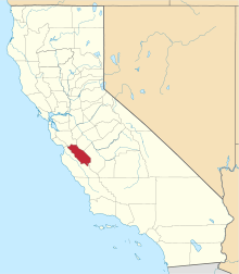 | |
| CDPs | ||
| Unincorporated communities | ||
| Ghost town | ||
| Footnotes | ‡This populated place also has portions in an adjacent county or counties | |
| Counties |  | |
|---|---|---|
| Cities and towns 100k-250k | ||
| Cities and towns 25k-100k | ||
| Cities and towns 10k-25k | ||
| Sub-regions | ||
Counties in italics sometimes included in the definition of the Central Coast | ||