Grade II* listed buildings in Guildford (borough)
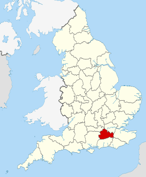
Surrey within England
Borough of Guildford within Surrey

There are over 20,000 Grade II* listed buildings in England. This page is a list of these buildings in the district of Guildford; for similar pages in relation to the other 10 districts in Surrey see Grade II* listed buildings in Surrey.

Name Location Type Completed [note 1]Date designated Grid ref.[note 2]
Geo-coordinates
Entry number [note 3]Image
Albury Park Albury Park, Albury Country house 16th century 14 June 1967 TQ0639047700
51°13′07″N 0°28′41″W / 51.218596°N 0.478035°W / 51.218596; -0.478035 (Albury Park)
1029565
Bath House and Terrace to Albury House, Tunnel Entrance Bath House and Terraces Albury Park, Albury Bath House 1667-1676 14 June 1967 TQ0651447964
51°13′15″N 0°28′34″W / 51.220946°N 0.476182°W / 51.220946; -0.476182 (Bath House and Terrace to Albury House, Tunnel Entrance Bath House and Terraces)
1029566
Catholic Apostolic Church and Chapterhouse Albury Park, Albury Church 1840 14 June 1967 TQ0603148144
51°13′22″N 0°28′59″W / 51.222654°N 0.483043°W / 51.222654; -0.483043 (Catholic Apostolic Church and Chapterhouse)
1029568
8 and 9 Littleton Lane Artington House 17th century 14 June 1967 SU9815547331
51°13′00″N 0°35′46″W / 51.216752°N 0.59601°W / 51.216752; -0.59601 (8 and 9 Littleton Lane)
1188281
Church of St Peter Ash Church 12th century 14 June 1967 SU8974750778
51°14′57″N 0°42′56″W / 51.249122°N 0.715498°W / 51.249122; -0.715498 (Church of St Peter)
1029647
Watts Gallery Compton House/Art Gallery 1903-4 4 June 1975 SU9584947807
51°13′17″N 0°37′44″W / 51.221423°N 0.628889°W / 51.221423; -0.628889 (Watts Gallery)
1188403
Church of St Martin East Horsley Church 12th century 14 June 1967 TQ0952452811
51°15′50″N 0°25′54″W / 51.263944°N 0.431617°W / 51.263944; -0.431617 (Church of St Martin)
1377815
Horsley Towers East Horsley Country house 1820-1829 14 June 1967 TQ0982552982
51°15′56″N 0°25′38″W / 51.265423°N 0.427252°W / 51.265423; -0.427252 (Horsley Towers)
1294810
Church of St Lawrence Effingham Church 12th century 14 June 1967 TQ1182953664
51°16′16″N 0°23′54″W / 51.271164°N 0.398328°W / 51.271164; -0.398328 (Church of St Lawrence)
1294793
Castle Arch Guildford House 1672 1 May 1953 SU9969549249
51°14′01″N 0°34′24″W / 51.233727°N 0.573434°W / 51.233727; -0.573434 (Castle Arch)
1189846
Cathedral Church of the Holy Spirit Guildford Anglican Cathedral 1936-1939 16 January 1981 SU9853850044
51°14′28″N 0°35′23″W / 51.241074°N 0.589783°W / 51.241074; -0.589783 (Cathedral Church of the Holy Spirit)
1377883
Church of St John the Evangelist Guildford Church 1858 1 May 1953 SU9982150725
51°14′49″N 0°34′16″W / 51.246973°N 0.571219°W / 51.246973; -0.571219 (Church of St John the Evangelist)
1294008
Church of St Nicholas Guildford Church 1875 1 May 1953 SU9941549346
51°14′05″N 0°34′39″W / 51.234648°N 0.577417°W / 51.234648; -0.577417 (Church of St Nicholas)
1029291
Lloyds Bank Guildford Bank 1765 1 May 1953 SU9979649503
51°14′10″N 0°34′19″W / 51.235993°N 0.571918°W / 51.235993; -0.571918 (Lloyds Bank)
1029287
The Angel Hotel Guildford House 19th century 1 May 1953 SU9966349457
51°14′08″N 0°34′26″W / 51.235602°N 0.573835°W / 51.235602; -0.573835 (The Angel Hotel)
1029282
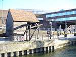
The Treadwheel Crane Guildford Treadwheel Crane Late C17/C18 1 May 1953 SU9943449434
51°14′08″N 0°34′38″W / 51.235436°N 0.57712°W / 51.235436; -0.57712 (The Treadwheel Crane)
1377866
72, 74, 76 and 78 High Street
[one, 1803-built two-bay mid-terrace
with 13th century undercroft.]
Guildford House 1803 1 May 1953 SU9967649432
51°14′07″N 0°34′25″W / 51.235375°N 0.573656°W / 51.235375; -0.573656 (72, 74, 76 and 78 High Street
[one, 1803-built two-bay mid-terrace
with 13th century undercroft.
)]
1180242
]
6 Quarry Street Guildford House Late C17/Early 18th century 1 May 1953 SU9964549300
51°14′03″N 0°34′27″W / 51.234194°N 0.574136°W / 51.234194; -0.574136 (6 Quarry Street)
1294017
8 and 8a Quarry Street Guildford House Late C17/Early 18th century 1 May 1953 SU9964849293
51°14′03″N 0°34′27″W / 51.234131°N 0.574095°W / 51.234131; -0.574095 (8 and 8a Quarry Street)
1029224
13 Quarry Street Guildford House Late C13/C14 1 May 1953 SU9966149262
51°14′02″N 0°34′26″W / 51.23385°N 0.573918°W / 51.23385; -0.573918 (13 Quarry Street)
1294022
55 Quarry Street Guildford House Pre 18th century 1 May 1953 SU9965649328
51°14′04″N 0°34′26″W / 51.234444°N 0.573971°W / 51.234444; -0.573971 (55 Quarry Street)
1029216
Norney Grange Norney, Shackleford House 1897 21 May 1985 SU9384044906
51°11′44″N 0°39′30″W / 51.195678°N 0.658406°W / 51.195678; -0.658406 (Norney Grange)
1029515
Stables to Ockham Park House Ockham Flats Early 18th century 14 June 1967 TQ0653856551
51°17′53″N 0°28′24″W / 51.298127°N 0.473284°W / 51.298127; -0.473284 (Stables to Ockham Park House)
1188468
Church of St Michael and All Angels Pirbright Church Rebuilt 1784 14 June 1967 SU9423055916
51°17′41″N 0°39′00″W / 51.294586°N 0.649932°W / 51.294586; -0.649932 (Church of St Michael and All Angels)
1377714
Church of St John the Baptist Puttenham Church 12th century 14 June 1967 SU9330847861
51°13′20″N 0°39′55″W / 51.222329°N 0.66525°W / 51.222329; -0.66525 (Church of St John the Baptist)
1029601
Puttenham Priory Puttenham Country house 1762 19 February 1957 SU9333447818
51°13′19″N 0°39′54″W / 51.221938°N 0.664889°W / 51.221938; -0.664889 (Puttenham Priory)
1294505
Church of St Mary the Virgin Ripley Church C20 14 June 1967 TQ0512356634
51°17′57″N 0°29′37″W / 51.299136°N 0.493548°W / 51.299136; -0.493548 (Church of St Mary the Virgin)
1188603
The Talbot Ripley Restaurant 16th century 14 June 1967 TQ0541456877
51°18′05″N 0°29′21″W / 51.301266°N 0.489304°W / 51.301266; -0.489304 (The Talbot)
1029372
Church of St Mary Send Church c.1240 14 June 1967 TQ0186954343
51°16′45″N 0°32′27″W / 51.279133°N 0.540858°W / 51.279133; -0.540858 (Church of St Mary)
1188756
Unstead Bridge Shalford Bridge 13th century 14 June 1967 SU9931145435
51°11′58″N 0°34′48″W / 51.199509°N 0.579988°W / 51.199509; -0.579988 (Unstead Bridge)
1029507
Shalford Mill Shalford Watermill Early 18th century 14 June 1967 TQ0010647635
51°13′09″N 0°34′05″W / 51.219147°N 0.568°W / 51.219147; -0.568 (Shalford Mill)
1294360
Unstead Manor Shalford Country house 16th century 14 June 1967 SU9940945442
51°11′58″N 0°34′43″W / 51.199555°N 0.578584°W / 51.199555; -0.578584 (Unstead Manor)
1294317
Fulvens House Shere House c.1620 14 June 1967 TQ0977046413
51°12′23″N 0°25′48″W / 51.206389°N 0.430051°W / 51.206389; -0.430051 (Fulvens House)
1294281
Old Hatch Farm House Shere House Late 19th century 14 June 1967 TQ0939447627
51°13′03″N 0°26′06″W / 51.217373°N 0.435062°W / 51.217373; -0.435062 (Old Hatch Farm House)
1377801
Usherwood Shere Bungalow Built 1934-36 17 October 2008 TQ0997645397
51°11′50″N 0°25′39″W / 51.197217°N 0.427415°W / 51.197217; -0.427415 (Usherwood)
1392952
Barn, 80 Yards West of Church of St Bartholomew Wanborough Barn 17th century 14 June 1967 SU9342948893
51°13′54″N 0°39′48″W / 51.231586°N 0.663249°W / 51.231586; -0.663249 (Barn, 80 Yards West of Church of St Bartholomew)
1029613
Greyfriars Wanborough House 1896 13 December 1984 SU9459748313
51°13′34″N 0°38′48″W / 51.22618°N 0.646678°W / 51.22618; -0.646678 (Greyfriars)
1029612
Church of St Peter and St Paul West Clandon Church Late 12th century 14 June 1967 TQ0441851250
51°15′03″N 0°30′19″W / 51.25087°N 0.505227°W / 51.25087; -0.505227 (Church of St Peter and St Paul)
1029360
Lodges and Gates to Clandon Park House West Clandon Gate Early 18th century 14 June 1967 TQ0305950832
51°14′50″N 0°31′29″W / 51.247359°N 0.524813°W / 51.247359; -0.524813 (Lodges and Gates to Clandon Park House)
1188805
Foxwarren Park Wisley Country House 1860 22 September 1981 TQ0794259972
51°19′43″N 0°27′08″W / 51.328612°N 0.452119°W / 51.328612; -0.452119 (Foxwarren Park)
1189110
Littlefield Manor Worplesdon House Late 17th century 14 June 1967 SU9587152099
51°15′36″N 0°37′39″W / 51.260001°N 0.627427°W / 51.260001; -0.627427 (Littlefield Manor)
1191554

Notes

  1. The date given is the date used by Historic England as significant for the initial building or that of an important part in the structure's description.
  2. Sometimes known as OSGB36, the grid reference is based on the British national grid reference system used by the Ordnance Survey.
  3. The "List Entry Number" is a unique number assigned to each listed building and scheduled monument by Historic England.

References

English Heritage Images of England

Media related to Grade II* listed buildings in Surrey at Wikimedia Commons

This article is issued from Wikipedia - version of the 4/9/2016. The text is available under the Creative Commons Attribution/Share Alike but additional terms may apply for the media files.