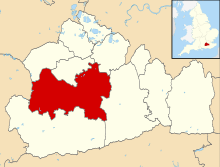
Worplesdon
| Worplesdon | |
 Whitmoor Common, Worplesdon (part) |
|
 St Mary's Church Grade I architectural listing |
|
 Worplesdon |
|
| Area | 17.94 km2 (6.93 sq mi) |
|---|---|
| Population | 8,529 (Civil Parish 2011) 1,503 (village and closest neighbourhoods only in 2001)[1][2] |
| – density | 475/km2 (1,230/sq mi) |
| OS grid reference | SU9753 |
| Civil parish | Worplesdon |
| District | Guildford |
| Shire county | Surrey |
| Region | South East |
| Country | England |
| Sovereign state | United Kingdom |
| Post town | Guildford |
| Postcode district | GU3 |
| Dialling code | 01483 |
| Police | Surrey |
| Fire | Surrey |
| Ambulance | South East Coast |
| EU Parliament | South East England |
| UK Parliament | Guildford |
Coordinates: 51°16′19″N 0°36′43″W / 51.272°N 0.612°W
Worplesdon is a village 3.1 miles (5.0 km) NNW of Guildford in Surrey, England and a large, quite dispersed civil parish that has the settlements of: Worplesdon itself (including its central church area, Perry Hill), Fairlands, Jacobs Well, Rydeshill and Wood Street Village, all various sized smaller settlements, well-connected by footpaths and local roads. Its area includes Whitmoor Common, which can be a collective term for all of its commons.
History
Early history
South of Broad Street, east of Wood Street Village on a farm in Broad Street Common are ruins of a Roman Villa – for further details see the Guildford article, as it is directly by the major town's western edge however in this parish.
Worplesdon has a Grade I C of E church, St Mary's with a 13th-century chancel and later additions.[3][4] Worplesdon's single manor appears in Domesday Book of 1086 as Werpesdune held by Turald (Thorold) from Roger de Montgomery. Its domesday assets were: 6½ hides; a church, 9 ploughs, a mill worth 2s 6d, 8 acres (3.2 ha) of meadow, wood worth 60 hogs. Its 22 households (of which one was a serf's)[5] rendered £10 sterling per year to its overlords.[6]
Early manorial owners includes (all cited as "de..."): Basseville, Holeye, (13th century) Wykford, Wintershall/Wintershull, Seymour (14th century); Ditton, Hegham, Wykford. Then we see Jasper Tudor (Earl of Pembroke, then created the Duke of Bedford) who was attainted, however following Edward IV's grant to the Duke of Clarence in 1474, it reverted to the last Duke of Bedford of the medieval creation (who died, childless).[7]
Sir Anthony Browne and his son, Anthony Browne, 1st Viscount Montagu, gained a royal lease of the manor in the Tudor period, followed by Lord Annandale in 1625 for three lifetimes. The Harbord family next held it followed by John Payne of Hurtmore and Thomas Newton of Stoke (next Guildford) who owned it in 1670. Its owners until 1911 acquired what remained of the estate as early as in 1681, the Onslow family, historically Earls of Surrey.[7]
The parish was divided into four tithings: Perry Hill, about the hill on which the church stands; Burpham, on the east side; West End; and Wyke. The last, which was separated from the rest of the parish, was added to Ash in 1890.[7]
Later Manors
- Frenches
The reputed and lost Frenches manor represented the knight's fee held there by Richard le French in 1349. In 1402 John French released the manor of Frenches to Robert Oyldesborough, brewer, of London, having briefly been held by William Hamonde, probably in trust and passed to Robert Russell in 1598. It is probably represented by Russell Place Farm. Anthony Russell was living in Worplesdon when Symmes wrote, about 1676[7]
- Merist Wood
In 1582 the queen, by charter, granted a lease to George More of Loseley of Merest Wood described as 82 acres (33 ha) of wood and wooded ground in the Forest of Windsor, in Worplesdon at £3 8s. per annum. In 1742 a related fine (lease premium) for this was sued for among two men of the Grenville family.[7]
- Wyke
In 1279 William of Wyke was holding this westerly manor. Divided between descendants Katerina, Joan and Christine in 1353, under the legal principle of female inheritance, "in moieties". Part holders' surnames thereafter included: Logge, Osbaldeston, Harding, Parker, Manory, Vyne, White in 1580 and in 1584 sold outright to William Harding, who thus acquired the whole again. Henceforth it descended with the manor of Claygate in Ash, Surrey.[7]
Post-Industrial Revolution
Adjacent to the church a London to Portsmouth semaphore tower (now demolished) served in the Napoleonic wars. The east window was embellished with stained glass, collected and arranged in 1802, at the expense of the Rev. W. Roberts and by the 1840s the whole parish's population was 1424 (which then included Burpham and Wyke).[8]
In 1911 the Victoria County History's guide to the area included the agricultural and economic description:
The village and church stand upon an abrupt hill of Bagshot sand (the Bracklesham Beds), but round it the soil is lower Bagshot sand. To the south the parish is on the London Clay...There are brick and tile works, and cement works in the parish, and nursery gardens. It is otherwise agricultural, and a great part of it is waste land. Whitmoor and Broad Street Commons are extensive wastes.[7]
This pinpoints the area's sands, hence low agricultural natural fertility as being key to the reason for Worpledon's abundance heath and woodlands. In traditional parish analysis such unproductive land is described as waste.
Landmarks and amenities

Whitmoor Common
A large common is at the heart of the parish that has mixed landscapes of heather, copses of woodland, grasslands and bracken.
Clustered around the village centre and its lightly developed localities are heavily wooded commons, managed by Surrey Wildlife Trust, including Broadstreet & Backside Commons, Stringer's Common, Littlefield Common, Whitmoor/Whitmore Common, Jordan Hill, Rickford Common, and Chitty's Common, and occasionally, Whitmoor Common is a collective term for them all.
Memorial hall and recreational grounds
Worplesdon is served by the Worplesdon Memorial Hall,[9] built in 1922 to recall those who died in World War I; it and the adjacent recreation grounds are managed by trustees representing the donors and the Parish Council. A caretaker lives nearby. Beside the Hall are a playground and tennis and cricket facilities. There are a large events room, a meeting room, and the Sidney Sime Memorial Gallery.
Hotel and convenience shopping
Worplesdon itself no longer has a parade of shopping or banking facilities however it has the Worplesdon Place Hotel and the rail station 1.2 miles (1.9 km) north-east of the village centre.
Wood Street Village and Stoughton amenities
Wood Street Village is, unusually, a larger "village" within the historic parish as well as the 19th-century created, civil parish.[10] Stoughton, Guildford has a diverse parade of shops and is well-situated to access most of the village.
Economy
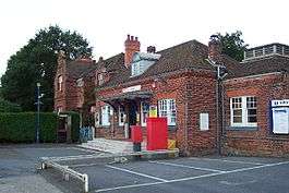

Worplesdon Railway station has 1–3 services per hour to London Waterloo, on Mondays to Saturdays on the Portsmouth Direct Line, as the station between Woking and Guildford, in the east of the village – 31–37 minutes from Waterloo.[11] This is separated from parts of the main village by the gently elevated northwestern flank of wooded Whitmore Common (Jordan Hill or Rickford Common), all of which are part of the village.
- Industries in the 2011 census
Taking the parish as a whole: 213 people at the time of the last census were employed in finance and insurance industries.[12] Despite the heathland only 0.8% of residents in 2011 were employed in quarrying, forestry and agriculture, similarly real estate accounted for 1.2% of residents' occupations.[12] Technical/scientific employers employed 10% of the population, bolstered by the University of Surrey and Institute for Animal Health (with associated major employers in life sciences, space exploration and computing).
Greater than this, education employed 12% of the population (549 people). Wholesale and retail trade, and the sale/repair of motor vehicles was the most important single category with 639 people. Next, just behind education, was Human Health and Social Work employing 495 people. Accommodation and food service activities, if combined with the similar category of arts, entertainment and recreation, employed a similar figure of 440 people.
Two neighbouring villages to the northwest are Pirbright and Deepcut with significant UK Army presences, although the latter's barracks has been redeveloped into homes. Public Administration and Defence; Compulsory Social Security's total of people was 38 fewer than Manufacturing, which gave employment to 239 people in 2011
Demography and housing
| Output area | Detached | Semi-detached | Terraced | Flats and apartments | Caravans/temporary/mobile homes | shared between households[2] |
|---|---|---|---|---|---|---|
| (Civil Parish) | 1,082 | 1,395 | 572 | 346 | 60 | 1 |
The average level of accommodation in the region composed of detached houses was 28%, the average that was apartments was 22.6%.
| Output area | Population | Households | % Owned outright | % Owned with a loan | hectares[2] |
|---|---|---|---|---|---|
| (Civil Parish) | 8,529 | 3,456 | 40.5% | 37.2% | 1,794 |
The proportion of households in the civil parish who owned their home outright compares to the regional average of 35.1%. The proportion who owned their home with a loan compares to the regional average of 32.5%. The remaining % is made up of rented dwellings (plus a negligible % of households living rent-free).
Nearest Settlements
 |
Pirbright and Brookwood | Woking (southwest of borough) including Fox Corner, Fisher's Hill and Hook Heath |
Mayford | |
| Normandy | |
across woodland, railway, farms, Jacobs Wells, and River Wey Send Burpham (borders) | ||
| ||||
| | ||||
| across Wood Street Village Puttenham |
across Fairfields Park Barn, Guildford |
Stoughton, Guildford Bellfields, Guildford |
Education
Merrist Wood Agricultural College stands on the hill in the west of the village, encompassing:
- A wood and pond
- Plant nursery
- Arboriculture training area
- Equestrian centre
- Golf course
- Mixed farm
The village’s Perry Hill School closed in 1976 to be replaced by Worplesdon Primary in Fairlands. Worplesdon Primary School caters for 409 students from the ages of 4–11. The head teacher is Mr A Parsons.[13]
Youth outreach
The Normandy Youth Center serves the area by sponsoring community-based programs targeting youth in the area (especially marginal groups and minorities) for the purpose of increasing exposure to educational opportunities and building a stronger community.[14]
Sports
The Worplesdon and Burpham Cricket Club traces its origins to 1890, and there is also Worplesdon Phoenix FC playing in the Surrey Counties Intermediate League and Guildford and Woking Alliance League[15] and, since 1991, Worplesdon Tennis Club,[16] with a new clubhouse (2005).
Worplesdon Rangers FC[17] is another football club based in and around the parish; the club was founded in 2001 and caters for pre-reception to Under 18 age-groups playing in the Surrey Primary League. Committee meetings are held monthly at Jacobs Well Village Hall.
Individuals
- Thomas Comber, Master of Trinity College, Cambridge, rector of Worplesdon (1615–42)[7]
- Stephen Smith, early Quaker, gave Friends' Burial Ground (buried there 1672) (sold 1852).
- John Burton, author: travel and defence of the study of Greek, theologian and rector of Worplesdon (1766–71).[7]
- Sir J. L. Walker, CIE of Worplesdon Place (1911);
- Lt. Col. Montgomery, of Rickford (1911)
In the early 20th century, Worplesdon was home to the artist Sidney Sime, best known for magazine illustration and work in the books of the varied, particularly fantasy, author Lord Dunsany.
In his later life Frederick Selous chronicled many of his adventures from his home in Worplesdon. Selous was a British explorer, officer, hunter, and conservationist, famous for his exploits in south and east of Africa. His real-life adventures inspired Sir H. Rider Haggard's Allan Quatermain character.[18][19]
Local Government
There is one representative on Surrey County Council, Conservative Keith Witham whose physically large ward extends into Normandy, Surrey.[20] There are three representatives on Guildford Borough Council:
| Last elected | Member[21] |
Ward | |
|---|---|---|---|
| 2011 | David Elms | Worplesdon | |
| 2011 | Bob McShee | Worplesdon | |
| 2011 | Isuelt Roche | Worplesdon | |
References
- ↑ Surrey County Council census data
- 1 2 3 Key Statistics; Quick Statistics: Population Density United Kingdom Census 2011 Office for National Statistics Retrieved 21 November 2013
- ↑ St Mary's Church Historic England. "Details from listed building database (1377735)". National Heritage List for England. Retrieved 27 May 2013.
- ↑ Worplesdon Parish Local Church of England website
- ↑ Domesday Map website retrieved 27 May 2013
- ↑ Surrey Domesday Book
- 1 2 3 4 5 6 7 8 9 H.E. Malden (editor) (1911). "Parishes: Worplesdon". A History of the County of Surrey: Volume 3. Institute of Historical Research. Retrieved 27 May 2013.
- ↑ Samuel Lewis (1848). "Worplesdon". A Topographical Dictionary of England. Institute of Historical Research. Retrieved 27 May 2013.
- ↑ Worplesdonmemorialhall.org.uk
- ↑ The Parish Council – the civil, secular community government council
- ↑ Official timetables from the Association of Train Operating Companies (ATOC)
- 1 2 2001 Census
- ↑ "OFSTED report 2005" (PDF). Retrieved 20 February 2007.
- ↑ Award for Mother Who Transformed Her Village; 18 October 2010 article; at Get Surrey News; retrieved 30 January 2013.
- ↑ Worplesdonphoenixfc.org.uk
- ↑ Worplesdontennis.org.uk
- ↑ worplesdonrangers.org
- ↑ Mandiringana, E.; T. J. Stapleton (1998). "The Literary Legacy of Frederick Courteney Selous". History in Africa. 25: 199–218. doi:10.2307/3172188.
- ↑ Pearson, Edmund Lester. "Theodore Roosevelt, Chapter XI: The Lion Hunter". Humanities Web. Retrieved 18 December 2006.
- ↑ "Surrey CC Councillors Elected by Ward 2013". Surrey County Council. Retrieved 27 May 2013.
- ↑ "Council Members". Guildford Borough Council. Retrieved 27 May 2013.
External links
| Wikimedia Commons has media related to Worplesdon. |
- Surreycc.gov.uk Surrey Government; retrieved 6 April 2007