Government Center (MBTA station)
GOVERNMENT CENTER
GOVERNMENT CENTER | ||||||||||||||||||||||||||||||||||||||||||
|---|---|---|---|---|---|---|---|---|---|---|---|---|---|---|---|---|---|---|---|---|---|---|---|---|---|---|---|---|---|---|---|---|---|---|---|---|---|---|---|---|---|---|
 Government Center headhouse upon reopening in March 2016 | ||||||||||||||||||||||||||||||||||||||||||
| Location |
1 Cambridge St Boston, Massachusetts | |||||||||||||||||||||||||||||||||||||||||
| Coordinates | 42°21′34″N 71°03′34″W / 42.35944°N 71.05944°WCoordinates: 42°21′34″N 71°03′34″W / 42.35944°N 71.05944°W | |||||||||||||||||||||||||||||||||||||||||
| Owned by | MBTA | |||||||||||||||||||||||||||||||||||||||||
| Line(s) | ||||||||||||||||||||||||||||||||||||||||||
| Platforms |
1 island platform (Blue Line) 1 triangular island platform (Green Line) | |||||||||||||||||||||||||||||||||||||||||
| Tracks |
Blue Line: 2 Green Line: 2 plus non-revenue loop track | |||||||||||||||||||||||||||||||||||||||||
| Connections |
| |||||||||||||||||||||||||||||||||||||||||
| Construction | ||||||||||||||||||||||||||||||||||||||||||
| Disabled access | Yes | |||||||||||||||||||||||||||||||||||||||||
| History | ||||||||||||||||||||||||||||||||||||||||||
| Opened |
September 3, 1898 (Green Line) December 30, 1904 (Court Street station) March 18, 1916 (Blue Line) | |||||||||||||||||||||||||||||||||||||||||
| Closed | November 15, 1914 (Court Street station) | |||||||||||||||||||||||||||||||||||||||||
| Rebuilt | March 22, 2014 – March 21, 2016[1][2] | |||||||||||||||||||||||||||||||||||||||||
| Previous names | Scollay Square (1898–1963) | |||||||||||||||||||||||||||||||||||||||||
| Traffic | ||||||||||||||||||||||||||||||||||||||||||
| Passengers (2013) | 10,828 (weekday average boardings)[3] | |||||||||||||||||||||||||||||||||||||||||
| Services | ||||||||||||||||||||||||||||||||||||||||||
| ||||||||||||||||||||||||||||||||||||||||||
Government Center is an MBTA subway station located at the intersection of Tremont, Court and Cambridge Streets in the Government Center area of Boston. It is a transfer point between the light rail Green Line and the rapid transit Blue Line. With the Green Line platform having opened in 1898, the station is the third-oldest operating subway station (and the second-oldest of the quartet of "hub stations") in the MBTA system; only Park Street and Boylston are older. The station previously served Scollay Square before its demolition for the creation of Boston City Hall Plaza.
The station was closed on March 22, 2014 for a major renovation, which included retrofitting the station for handicapped accessibility and building a new glass headhouse on City Hall Plaza. The new fully accessible station was reopened on March 21, 2016.[4]
History
Scollay Square

The northern section of the Tremont Street Subway opened on September 3, 1898, with a station at Scollay Square.[1] The station had an unusual platform design. The three-sided main platform served northbound and southbound through tracks plus the Brattle Loop track, one of two turnback points (along with Adams Square) for streetcars entering the subway from the north; a side platform also served the loop[5]:23 Boston Elevated Railway (BERy) streetcars from Everett, Medford, and Malden (which formerly ran to Scollay Square on the surface) used Brattle Loop, as did cars from Lynn and Boston Railroad and its successors. The last of those, the Eastern Massachusetts Street Railway, used the loop until 1935.[5]:23,38
On June 10, 1901, Main Line Elevated trains began using the through tracks through the Tremont Street Subway, while streetcars continued using the Brattle Loop.[1] The main platform was divided into separate sections for northbound and southbound elevated trains, each with separate staircases and ticket takers, with sliding platform sections to meet the high-level doors on the El cars. Passages under the Brattle Loop were built from each side to the Brattle Loop platform, which had its own staircases and ticket takers for streetcars. On July 9, 1904, streetcar passengers began paying fares to the streetcar conductors and the streetcar ticket office was repurposed for southbound El passengers.[6]:15
Court Street

On December 30, 1904, the East Boston Tunnel opened for streetcars from Maverick Square in East Boston to a one-track stub-end terminal at Court Street next to Scollay Square. A passageway was built connecting the two stations.[5]:39 On November 30, 1908, Elevated trains moved into the parallel Washington Street Tunnel and the through tracks returned to streetcar operations.[1] The separated platform areas were kept; the through tracks offered a free transfer to East Boston Tunnel streetcars (plus a small toll for use of the tunnel, separate from normal BERy fares), while the Brattle Loop platform was kept separate for "foreign" (non-BERy) cars on a separate fare system.[6]:23
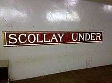
Scollay Under

In 1912, the BERy began an extension of the East Boston Tunnel west to Bowdoin. Court Street station was abandoned and the passageway closed on November 15, 1914.[5]:39 The floor of the station was removed and the tunnel angled down through the former station to allow for the extended tunnel to proceed under the existing Scollay Square station.[7][8] Scollay Under opened on March 18, 1916, an island platform with staircases to Scollay station. The 1898-built main platform was extended during the project to accommodate expected loads of transferring passengers.[5]:39 On April 18, 1924, the East Boston Tunnel including Scollay Under was converted from low-platform streetcars to high-platform third-rail-powered rapid transit.[1] A portion of the low streetcar platform remained east of the new high platform.[7]
The station was renovated in 1928 with the removal of the original entrance kiosk, new lights, and improved fare collection equipment. Eastern Massachusetts Street Railway service to Brattle Loop ended on January 13, 1935, though some BERy streetcars continued to use it.[5]:38 The Metropolitan Transit Authority (MTA) replaced the BERy in 1947 and continued to reduce streetcar services. The last Brattle Loop service was discontinued in 1952. The northbound platform was extended over the loop in 1954 to allow two 3-car trains of PCC streetcars to board simultaneously.[6]:23
Government Center


Boston City Hall Plaza replaced Scollay Square in the early 1960s. Scollay Square station was wholly renovated, and the northbound tunnel was realigned to accommodate the foundation of Boston City Hall. The work drastically altered the shape of Brattle Loop and provided a new northbound-to-southbound turnback loop. The stairways to the lower level were relocated, and a fare lobby was built in a low brick structure at the surface.[5]:23-24 The 1963-built headhouse was often described as resembling a bunker or a cave, even by MBTA management.[9] Government Center station was dedicated on October 28, 1963, though the new loop was not activated until November 18, 1964, when the Commonwealth Avenue line was extended from Park Street to Government Center.[1] Despite the new name, several tiles mosaics reading "Scollay Under" and "S" were still extant and gradually uncovered over the years.
On August 26, 1965, as part of a wholesale rebranding of the system, the MBTA (formed in 1964 to replace the MTA) designated the remaining streetcar routes as the Green Line and the East Boston Tunnel line as the Blue Line.[1] In 1968-69, a "Phase I" modernization added false ceilings, fluorescent lights, and other aesthetic upgrades.[6]:24
In the late 1970s, Mary Beams - an artist at Harvard’s Carpenter Center for the Visual Arts - painted 19 murals which were placed along the wall behind the Brattle Loop. Although intended to be temporary, they received protective covers in the late 1980s and remained in good condition until the 2014 closure.[10]
On February 11, 1983, the Green Line "E" Branch was shut down by snow for several days; a Government Center-Lechmere shuttle ran in its stead - the first use of the Brattle Loop in three decades. Even after the "E" Branch resumed operations several days later, the shuttle service ran until June 21, 1997.[1] Since, the loop was used only for temporary car storage, largely during events at TD Garden.
Renovation


_at_Government_Center%2C_March_2016.JPG)
In 1990, the state agreed to a number of transit expansion and renovation projects to settle a lawsuit from the Conservation Law Foundation over the environmental impacts of the Big Dig.[4] Due to its cost, complexity, and the need to completely shut down a major transfer station, Government Center was the last of 80 key stations to be upgraded for handicapped accessibility. Site preparation began in mid-2013, and the main construction contract was awarded to Barletta Heavy Division in July 2013.
On March 22, 2014, Government Center Station closed for two years for the reconstruction, which included new elevators, station entrance and lobbies, emergency exit-only structure on Cambridge Street between Court and Sudbury Street, escalators, LED signage, expanded fare collection area, upgraded back-up electrical power supply, improved interior finishes, station lighting, mechanical systems, and public address system. Additional vendor retail space was provided on both Green Line and Blue Line platforms. The platform levels feature terrazzo flooring color-coded to the lines.[11]
During Government Center station's closure, Green Line trains passed through but did not stop at the station. For the duration of the closure, the "B" Branch was cut back to Park Street, while the "D" Branch was cut to Park Street at rush hours and North Station at other times. The "C" and "E" branches kept their usual terminals. Bowdoin station was kept open for all MBTA operating hours (for the first time since 1981) during the closure. A shuttle bus, the 608 Haymarket via Government Center Loop route, operated in a loop from Haymarket station via State Street station, Government Center station, and Bowdoin station.[12]
During the first two months of renovations, two additional Scollay Under tile signs were uncovered on the Blue Line level.[13] After the first sign was discovered in April, the MBTA announced that it would be restored and placed in the renovated station, similar to previously found mosaics at South Station and Arlington.[14] In total, five 'Scollay Under', one 'Scollay', and two single-letter mosaics were restored. An original faregate, ticket booth, and ceiling arches were also found.[15][16] The 1970s Mary Beams murals - made of house paint on plywood - did not meet fire code for installation in the rebuilt station. Instead, they were sold at auction in October 2015, with the proceeds going to an enamel commemorative panel and new artworks placed in the new station.[10]
By September 2014, demolition was completed and the steel frame of the new glass headhouse had been erected. At that point, the project was on schedule and on budget.[15] In July 2015 the MBTA announced that the project was still on schedule for a Spring 2016 reopening.[11] In August 2015, the MBTA revealed that the glass used on the headhouse was defective due to poor workmanship, with failed seals between the double-paned glass causing fogging. The glass was replaced at the contractor's expense and did not affect the project's schedule.[17]
On February 2, 2016, the MBTA announced that the station would reopen on March 26, 2016 and that the project was within its budget.[18] On February 19, the MBTA tested multicolored LED lights that will illuminate the glass headhouse.[19] After several unpublicized notices, the MBTA announced on March 9 that the station would open on March 21 instead, with a ceremony at 11:45am and full opening an hour later.[2] On the radio command of Governor Charlie Baker, service to the station resumed at 12:43pm.[4]
Design and engineering for the station cost $25 million; the MBTA estimated the construction cost would be $91 million. The primary construction contract was for $82 million, and total construction cost was $88 million.[20]
The new station headhouse design was heavily criticized in a monthly architectural review by the social commentator and critic James Howard Kunstler.[21] The headhouse has also been criticized[22] for blocking the view of Old North Church from Tremont Street.
Green Line congestion and Red-Blue Connector
The Red and Blue Lines are the only pair of rapid transit lines in the MBTA system that lack a direct transfer connection. Before the Government Center station was closed for reconstruction, the Green Line was the most convenient way to transfer between the Blue Line and the Red Line, thus causing the short Green Line segment between Government Center station and nearby Park Street station to be especially congested during peak travel times. This bottleneck, combined with tight platform clearances on the Green Line outbound side at Government Center, has been the cause of significant delays and crowding on the Green Line. In the past, an underground pedestrian passage had been proposed, paralleling the Green Line tracks and connecting the two stations (similar to the Winter Street Concourse between Park Street and Downtown Crossing), but this idea was dropped in favor of a direct transfer connection between the Blue and Red Lines, at Charles/MGH station. However, there are no active plans to build this link.
It also is possible to transfer between the Red and Blue Lines by traveling one stop on the Orange Line between State and Downtown Crossing stations, but this path involves navigating a much longer and more convoluted path through stairs and passages of those stations. For the duration of Government Center's closure, this was the only connection between these lines without exiting fare control.
Bus connections
Two MBTA Bus express routes stop at Government Center:[23]
- 352 Burlington Express - Boston via Route 128 & I-93
- 354 Woburn Express - Boston via Woburn Sq. & I-93
In popular culture
In the folk song "M.T.A.", popularized by the Kingston Trio, Government Center Station (then still called Scollay Square) is where fare-hike victim Charlie is given lunch by his wife: "Through the open window / she hands Charlie a sandwich / as the train comes a-rumbling through!"
Government Center station was featured in the video game Tony Hawk's Underground 2 in the Boston level.
In the 2015 video game Fallout 4 (2015), the former Scollay Square station has been converted into a bar known as the 'Third Rail'
References
- 1 2 3 4 5 6 7 8 Belcher, Jonathan (27 June 2015). "Changes to Transit Service in the MBTA district 1964-2015" (PDF). NETransit. Retrieved 12 August 2015.
- 1 2 Vaccaro, Adam (9 March 2016). "MBTA moves Government Center opening date to March 21". Boston Globe. Retrieved 9 March 2016.
- ↑ "Ridership and Service Statistics" (PDF) (14 ed.). Massachusetts Bay Transportation Authority. 2014. Retrieved 30 July 2014.
- 1 2 3 Moskowitz, Eric (21 March 2016). "Government Center reopens". Boston Globe. Retrieved 21 March 2016.
- 1 2 3 4 5 6 7 Clarke, Bradley H.; Cummings, O.R. (1997). Tremont Street Subway: A Century of Public Service. Boston Street Railway Association. ISBN 0938315048.
- 1 2 3 4 Chasson, George Jr. (1987). Lonto, Arthur J., ed. "Boston's Main Line El: The Formative Years 1879-1908". Headlights. Electric Railroader's Association. 49.
- 1 2 Belcher, Jonathan. "Remnants of Abandoned Stations, Tunnels, and Station Entrances found on the MBTA". NETransit. Archived from the original on 12 November 2007.
- ↑ Bierman, Noah (26 December 2009). "Transit archeology: Tour of abandoned subway network offers a glimpse of how the T was built". Boston Globe. Retrieved 12 August 2015.
- ↑ Weir, Richard (4 October 2010). "Redesign fits Government Center to a T". Boston Herald. Retrieved 3 August 2014.
- 1 2 Gay, Malcolm (17 September 2015). "MBTA tracks down artist who created iconic murals". Boston Globe. Retrieved 1 October 2015.
- 1 2 Dungca, Nicole (31 July 2015). "Is Government Center station still on track?". Boston Globe. Retrieved 11 August 2015.
- ↑ MBTA > Riding the T
- ↑ Powers, Martine (7 May 2014). "Second 'Scollay Under' sign found at Government Center". Boston Globe. Retrieved 9 May 2014.
- ↑ Powers, Martine (7 April 2014). "'Scollay Under' sign uncovered at Government Center station". Boston Globe. Archived from the original on 8 April 2014. Retrieved 9 May 2014.
- 1 2 Crimaldi, Laura (21 September 2014). "Government Center T station to feature glass entryway". Boston Globe. Retrieved 22 September 2014.
- ↑ Fiore, Rebecca (23 June 2015). "Scollay Square signs to remain after Government Center overhaul". Boston Globe. Retrieved 24 June 2015.
- ↑ Deehan, Mike (24 August 2015). "MBTA: Green Line Somerville Extension Faces $1B Overrun; Gov't Center Glass Needs To Be Replaced". WGBH. Retrieved 25 August 2015.
- ↑ Vaccaro, Adam (2 February 2016). "Government Center T station to reopen March 26". Boston Globe. Retrieved 3 February 2016.
- ↑ Annear, Steve (19 February 2016). "MBTA tests lights at new Government Center Station". Boston Globe. Retrieved 19 February 2016.
- ↑ Vaccaro, Adam (19 March 2016). "Why the MBTA shut down Government Center for 2 years". Boston Globe. Retrieved 21 March 2016.
- ↑ Kunstler, James Howard. "Eyesore of the Month". James Howard Kunstler. Retrieved 2015-05-05.
- ↑ DeLuca, Nick (11 December 2014). "Here Lies a Plaque: You Can't See the Old North Church From This Spot Anymore". BostInno. Retrieved 23 March 2016.
- ↑ "Government Center Station Neighborhood Map" (PDF). Massachusetts Bay Transportation Authority. April 2012. Retrieved 22 March 2016.
External links
| Wikimedia Commons has media related to Government Center (MBTA station). |
| Subway lines (List of stations) |
| |||||||||||
|---|---|---|---|---|---|---|---|---|---|---|---|---|
| Commuter Rail lines (List of stations) |
| |||||||||||
| Bus routes (List of routes) | ||||||||||||
| Other services | ||||||||||||
| Component parts of system lines | ||||||||||||
| Capital projects |
| |||||||||||
| History |
| |||||||||||
| Other | ||||||||||||