Tremont Street Subway
|
Tremont Street Subway | |
|
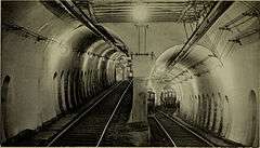
A flying junction on the now-abandoned southern branch of the Tremont Street Subway, south of Boylston station, approaching the Pleasant Street Incline (1898 photo) | |
   | |
| Location | Boston, Massachusetts |
|---|---|
| Coordinates | 42°21′23″N 71°3′47″W / 42.35639°N 71.06306°WCoordinates: 42°21′23″N 71°3′47″W / 42.35639°N 71.06306°W |
| Built | 1897 |
| Architect | Carsen, Howard A. |
| Architectural style | Classical Revival |
| NRHP Reference # | 66000788[1] |
| Significant dates | |
| Added to NRHP | October 15, 1966 |
| Designated NHL | January 29, 1964 |

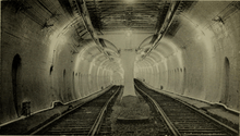
The Tremont Street Subway in Boston's MBTA Subway system is the oldest subway tunnel in North America and the third oldest worldwide to exclusively use electric traction (after the City and South London Railway in 1890, and the Budapest Metro's Line 1 in 1896), opening on September 1, 1897.[2][3] It was originally built to get streetcar lines off the traffic-clogged streets, instead of as a true rapid transit line. It now forms the central part of the Green Line, connecting Boylston Street to Park Street and Government Center stations.
The tunnel originally served five closely spaced stations: Boylston, Park Street, Scollay Square, Adams Square, and Haymarket, with branches to the Public Garden Portal and Pleasant Street Incline south of Boylston. Park Street, Scollay Square, and Haymarket stations were altered over the next two decades as transfers were added to the Cambridge-Dorchester Subway, East Boston Tunnel, and Main Line Elevated (now part of the Red, Blue, and Orange Lines, respectively). In 1962, the southern portal at Pleasant Street was closed; the following year, the northern half of the tunnel was substantially altered when Government Center and a new Boston City Hall replaced Scollay Square and Adams Square. The northbound tunnel to Haymarket station was rerouted; the southbound tunnel is still original. Scollay Square station was rebuilt as Government Center, and Adams Square station was closed.[4] In 1971, the original Haymarket station was replaced with a new station just to the south.[4]
Disused southern tunnel branch
The subway in 1897 consisted of a main line under Tremont Street that terminated at Park Street, and two forks to the south. One fork has remained the extant part of the line, which veered westward along Boylston Street, toward Back Bay. The other fork continued south under Tremont Street to the Pleasant Street Incline (depicted in the top right photo). This portal was used by streetcars that went southwest to Egleston via the South End, along Tremont Street (route 43), or southeast to City Point in South Boston via Broadway (route 9). Streetcar service through the southern portal ended in 1961; for the last several months, service consisted of a shuttle between the portal and Boylston station. The tunnel still exists, dead-ended at the now-buried portal, which has been converted to a public park.
Portals
The three original tunnel entrances were in the Boston Public Garden, at North Station/Canal Street, and at Pleasant Street. Over time, these portals were replaced and abandoned as the subway was extended. Vestiges of various closed portals are still visible inside the tunnel extending west of Boylston station towards Kenmore Square station.
The western Public Garden portal was replaced in 1914 with two portals, one in the middle of Boylston Street adjacent to the old portal, and the other at the west end of the Boylston Street Subway, just east of Kenmore Square. The Boylston Street portal was sealed in 1941 when the Huntington Avenue Subway was opened (with a new portal at Northeastern University). The portal at Kenmore Square was replaced in 1932 when the subway was extended west beyond the Square, to the existing portals on Commonwealth Avenue (the "B" branch) and Beacon Street (the "C" branch), although the top arch of the original portal survives as part of a ventilation shaft. The Fenway portal for the "D" branch was opened in 1959.
The northern portal at Canal Street was replaced in 2004 when the subway was extended beneath North Station to a new portal next to Martha Road.
The southern portal at Pleasant Street was abandoned in 1962 following the end of streetcar service through the South End. The portal has since been sealed up and covered by Elliot Norton Park, but the dead-ended tunnel to Boylston survives underground.
Power
The subway uses trolleys powered by electricity from overhead lines, which had been made possible by the invention of the trolley pole in 1880 by Frank J. Sprague.[5] The line has been pantograph-only since the trolley wires were modified in the 1990s.
Landmark status and ownership
The Tremont Street Subway was designated a National Historic Landmark in recognition for its pioneering role in the development of the subway as a public transit system in the United States. The landmark designation encompasses the still-extant portions of the early tunnel, roughly from Court Street to Charles Street, and includes the original Classical Revival head houses of the Park and Boylston stations which are still in use.[6]
The original owner of the Tremont Street Subway was the private West End Street Railway, later the Boston Elevated Railway. Public ownership began in 1947 with the Metropolitan Transit Authority, now the Massachusetts Bay Transportation Authority.
See also
- List of National Historic Landmarks in Boston
- National Register of Historic Places listings in northern Boston, Massachusetts
References
- ↑ National Park Service (2007-01-23). "National Register Information System". National Register of Historic Places. National Park Service.
- ↑ The Boston Daily Globe, "First Car off the Earth: Allston Electric Goes into the subway on schedule time.", The Boston Daily Globe, September 1, 1897. Experiences of the first Subway Riders in Boston.
- ↑ Most, Doug (26 January 2014). "The bigger dig". Boston Globe. Retrieved 22 January 2016.
- 1 2 Belcher, Jonathan (26 December 2015). "Changes to Transit Service in the MBTA district 1964-2015" (PDF). NETransit. Retrieved 22 January 2016.
- ↑ "Boston Transit Milestones", MIT course, 2002 (archived 2007)
- ↑ "NHL nomination for Tremont Street Subway" (PDF). National Park Service. Retrieved 2014-06-06.
Further reading
- Bierman, Noah, "Transit archeology: Tour of abandoned subway network offers a glimpse of how the T was built", Boston Globe, Saturday, December 26, 2009.
- Moore, Scott, "100 Years of the Tremont Street Subway" (archived 2007)
External links
| Wikimedia Commons has media related to Tremont Street Subway. |
- Celebrate Boston's description and image gallery of the Tremont Street Subway
- Photos and discussion of the Tremont Street subway tunnel
- Photos of the Tremont Street subway
- Google Books' online reprint of the Mid-August 1898 report on the Tremont Street Subway
| Subway lines (List of stations) |
| |||||||||||
|---|---|---|---|---|---|---|---|---|---|---|---|---|
| Commuter Rail lines (List of stations) |
| |||||||||||
| Bus routes (List of routes) | ||||||||||||
| Other services | ||||||||||||
| Component parts of system lines | ||||||||||||
| Capital projects |
| |||||||||||
| History |
| |||||||||||
| Other | ||||||||||||
| Topics |  | ||||||||||||||||||||||||||||||
|---|---|---|---|---|---|---|---|---|---|---|---|---|---|---|---|---|---|---|---|---|---|---|---|---|---|---|---|---|---|---|---|
| Lists by county | |||||||||||||||||||||||||||||||
| Lists by city |
| ||||||||||||||||||||||||||||||
| Other lists | |||||||||||||||||||||||||||||||
| |||||||||||||||||||||||||||||||