Grand Junction Railroad and Depot Company
| Grand Junction Railroad and Depot Company | |||||||||||||||||||||||||||||||||||||||||||||||||||||||||||||||||||||||||||||||||||||||||||||||||||||||||
|---|---|---|---|---|---|---|---|---|---|---|---|---|---|---|---|---|---|---|---|---|---|---|---|---|---|---|---|---|---|---|---|---|---|---|---|---|---|---|---|---|---|---|---|---|---|---|---|---|---|---|---|---|---|---|---|---|---|---|---|---|---|---|---|---|---|---|---|---|---|---|---|---|---|---|---|---|---|---|---|---|---|---|---|---|---|---|---|---|---|---|---|---|---|---|---|---|---|---|---|---|---|---|---|---|---|
|
Route of the Grand Junction Railroad | |||||||||||||||||||||||||||||||||||||||||||||||||||||||||||||||||||||||||||||||||||||||||||||||||||||||||
| Overview | |||||||||||||||||||||||||||||||||||||||||||||||||||||||||||||||||||||||||||||||||||||||||||||||||||||||||
| Locale | Boston, Massachusetts | ||||||||||||||||||||||||||||||||||||||||||||||||||||||||||||||||||||||||||||||||||||||||||||||||||||||||
| Termini | East Boston Terminal | ||||||||||||||||||||||||||||||||||||||||||||||||||||||||||||||||||||||||||||||||||||||||||||||||||||||||
| Technical | |||||||||||||||||||||||||||||||||||||||||||||||||||||||||||||||||||||||||||||||||||||||||||||||||||||||||
| Line length | 8.55 mi (13.76 km) | ||||||||||||||||||||||||||||||||||||||||||||||||||||||||||||||||||||||||||||||||||||||||||||||||||||||||
| Track gauge | 1,435 mm (4 ft 8 1⁄2 in) | ||||||||||||||||||||||||||||||||||||||||||||||||||||||||||||||||||||||||||||||||||||||||||||||||||||||||
| Loading gauge | Minimal Plate B | ||||||||||||||||||||||||||||||||||||||||||||||||||||||||||||||||||||||||||||||||||||||||||||||||||||||||
| |||||||||||||||||||||||||||||||||||||||||||||||||||||||||||||||||||||||||||||||||||||||||||||||||||||||||
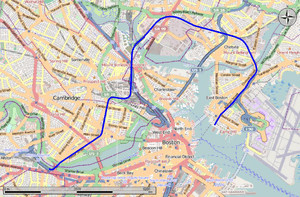
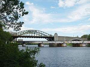
The Grand Junction Railroad is an 8.55-mile (13.76 km) long railroad in the Boston, Massachusetts area, connecting the railroads heading west and north from Boston. Most of it is still in use, carrying scrap either inbound or outbound to the Schnitzer scrap yard on the Everett waterfront[1] or freight to the Chelsea Produce Market,[2] and non-revenue transfers of Amtrak and MBTA passenger equipment between the lines terminating at North Station and South Station. The line is also notable for its railroad bridge over the Charles River that passes under the Boston University Bridge between Boston and Cambridge, Massachusetts. This is one of three places worldwide where, simultaneously, an airplane could pass over an automobile passing over a train passing over a boat. The other locations are the Steel Bridge over the Willamette River in Portland, Oregon and the 25 de Abril Bridge over the Tagus River in Lisbon and Pragal, Portugal.[3]
History

The railroad (full name Grand Junction Railroad and Depot Company) was chartered April 24, 1847 to connect the railroads entering Boston from the north and west with its wharves in East Boston. This was a rechartering of the Chelsea Branch Railroad, incorporated April 10, 1846.
The first section to open was from East Boston to the Boston and Maine Railroad in Somerville, opened in 1849. It began at a huge waterfront yard complex on Boston Harbor, occupying the space east of the Eastern Railroad terminal and west of the Boston, Revere Beach and Lynn Railroad terminal. The line headed north with two tracks (minimum) just east of the Eastern Railroad's line, crossing at-grade and splitting to the west just south of Curtis Street, with a crossover track between the two lines south of the crossing (allowing Eastern Railroad trains from their terminal to use the Grand Junction). In 1905, the Grand Junction Railroad in East Boston was rebuilt into a below-grade two-track line, and the Eastern Railroad line was truncated to just north of the split.
Next the Grand Junction crossed Chelsea Creek into Chelsea. It passed north of downtown Chelsea and through outlying areas of Everett before crossing the Mystic River into Somerville and running along the east side of the Boston and Maine Railroad's main line towards Boston. It soon crossed the border into Charlestown, part of Boston. Just south of Cambridge Street, the Grand Junction junctioned with and crossed the B&M. After crossing the B&M, the extension immediately crossed the Mystic River Branch of the Boston and Lowell Railroad, just before crossing back into Somerville. In Cambridge it crossed under the old B&L mainline (with track connections) and merged with the Fitchburg Railroad.
In March 1852 the line was leased to the Eastern Railroad between the B&M in Somerville and Salem Turnpike (now called Broadway) in Chelsea. The Eastern Railroad, then ending in East Boston, used the line for downtown Boston access, building a cutoff in 1854 from their main line to the Grand Junction in Chelsea, and building a new line splitting from the Grand Junction just west of the B&M and B&L Mystic River Branch crossing and running just west of the B&M into downtown. The Saugus Branch Railroad, bought by the Eastern April 30, 1852, was realigned in 1855 at its south end to feed into the Grand Junction rather than the B&M.
The rest of the line was built in 1856, connecting to the Boston and Worcester Railroad in Allston, now part of Boston. Instead of merging with the Fitchburg Railroad, it continued west along its north side for a bit (passing under the Boston and Lowell Railroad's new alignment) before turning south, crossing the Fitchburg Railroad at-grade onto its own alignment through Cambridge. A track connection was provided with the Fitchburg Railroad, connecting the East Boston-bound Grand Junction to the Fitchburg-bound Fitchburg.
After running through Cambridge along what was once the shore of the Charles River and is now a rough border between the main campus of the Massachusetts Institute of Technology and the rest of Cambridge, the line crossed the river diagonally on a bridge under the Essex Street Bridge (now the Boston University Bridge) and joined with the Boston and Worcester Railroad (after 1867, the Boston and Albany Railroad).
The line was reorganized as the East Boston Freight Railroad in 1862, and the Boston and Albany bought the property in 1869. It passed with the B&A into larger companies - the New York Central Railroad, Penn Central and Conrail. On February 28, 1955 the counterweight fell off the Chelsea Creek drawbridge, taking the bridge permanently out of service; subsequently B&A trains reached East Boston from Chelsea using B&M trackage rights via Revere. B&A service to East Boston ended around 1972.
A small footnote is the Union Railroad, which was incorporated May 10, 1848 for the same purpose, and was authorized to merge with the Grand Junction February 25, 1854.
Current status
West segment

The section of the Grand Junction between the now gone Beacon Park Yard and the Fitchburg Line is used by the MBTA to transfer southside commuter rail equipment to and from the MBTA Commuter Rail Maintenance Facility, and by Amtrak to transfer Downeaster equipment to and from Southampton Street Yard. CSX Transportation operates one daily freight to the New England Produce Center and scrap yards in Everett. The Barnum and Bailey Circus train often parks on the Grand Junction while the circus is in Boston. The track loading gauge is the minimal Plate B.[4]
The section of line is owned by MassDOT, although MIT owns the land of two segments with an easement for rail use.[5][6] On September 2009, the Commonwealth of Massachusetts finalized an agreement to purchase several CSX rail lines in eastern Massachusetts, including the western section of the Grand Junction.[7][8] A first closing on June 11, 2010 transferred dispatching control of the line from CSX to the MBTA's commuter rail operator.[9][10] The second closing on October 4, 2012 transferred ownership of the Grand Junction and several other important lines to the state, completing the $100 million deal.[11]
On November 16, 2012, Amtrak and MBTA equipment moves were limited to 5 miles per hour (8.0 km/h) over the Grand Junction Railroad Bridge, and freight traffic was not allowed to use the bridges. On November 21, the bridge was closed to all rail traffic due to its poor condition. While emergency repairs were under way, trains moving between the north and south sides of Boston had to be routed via Pan Am Railways trackage between Ayer, Massachusetts and Worcester, Massachusetts, a lengthy detour.[12] The bridge reopened in early January 2013, but was closed again from March to June for additional structural repairs.
East segment
From the Fitchburg Line to the Haverhill Line (shared at that point by the Newburyport/Rockport Line), the former Grand Junction is occupied by tracks which allow freight trains to move between the four northside main lines. The Newburyport/Rockport Line parallels the Grand Junction right-of-way from there to Broadway in Chelsea, Massachusetts. In Everett, freight yard tracks occupy the Grand Junction right of way; in Chelsea, the Silver Line Gateway busway is under construction from Everett Avenue to Eastern Avenue. CSX filed to abandon the section from 2nd Street in Everett to Saratoga Street in East Boston in 2002; the abandonment process was still under way when that segment was included in the 2009 agreement. By the 2010 and 2012 closings, an additional segment to the west in Everett was included in the sale to MassDOT.[13]
The section in East Boston, which largely shared a right of way with the Eastern Railroad's East Boston Branch, has fragmented ownership and uses. The section from Curtis Street to Lovell Street was transferred to Massport ownership and converted into the Martin A. Coughlin Bypass Road, a two-lane route for commercial traffic to and from Logan Airport that opened on November 26, 2012.[14]
Conrail abandoned the line between Lovell Street and the East Boston docks in the 1970s. The former rail yards north of Route 1A were used as a private "Park'N'Fly" lot for Logan Airport. In 1989, the Massachusetts Highway Department began proceedings to acquire the land by eminent domain as part of the Big Dig project. Since the Third Harbor Tunnel would bring additional traffic to Logan Airport, the site was to be converted to a public park, in partial restitution for the 1969 destruction of Wood Island Park for airport expansion.[15] After a lengthy scandal over the proposed land taking (and later land swap) that sent Speaker of the Massachusetts House of Representatives Charles Flaherty to jail and implicated others including U.S. Representative Bud Shuster, Massport purchased the land outright in 2001.[16] In 2007, Bremen Street Park opened on the site.[15]
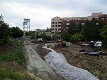
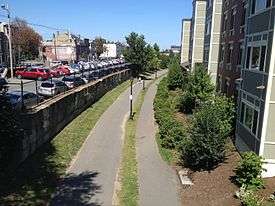
The remaining section to the south lay unused. Residents tried to clean up the tracks for use as a greenbelt in 1978, although local business leaders desired to reuse it as a haul road. Conrail donated that section to The Trust for Public Land in 1997. In 2007, after eight years of construction, the East Boston Greenway was opened on the corridor.[15]
Proposals

The City of Cambridge has done a feasibility study concerning adding a "rail with trail" multi-use path to be known as the Grand Junction Community Path from the Charles River Bike Paths at the Boston University Bridge, through MIT, paralleling Cardinal Medeiros Way northeast of Kendall Square, and connecting to the proposed extension of the Somerville Community Path near Twin City Plaza.[17]
The "locally preferred alternative" for the Urban Ring project as of June 2008 calls for routing bus rapid transit along the Grand Junction right-of-way, from George Washington Park in Cambridgeport, over the Charles River. The existing railroad bridge would be widened to add lanes for buses and the path.
In 2010, Lieutenant Governor Tim Murray publicly discussed branching the Framingham/Worcester Line over the Grand Junction to provide MBTA Commuter Rail service from Worcester to North Station.[18][19]
In December 2011, the Massachusetts Department of Transportation announced that "is not pursuing the use of the Grand Junction for increased MBTA Commuter Rail service at this point," opting instead to expand South Station, which would allow more service from Worcester without the need for a North Station route. It further stated: "However, expanding Boston South Station is an enormously complex and expensive project without a specific timeframe. Should the need for increased Commuter Rail capacity become overwhelming in the period prior to the expansion of South Station, MassDOT might reopen the Grand Junction discussion. The use of Grand Junction for Commuter Rail service could meet some of the needs to be provided by an expanded South Station, at much lower cost and with much less time and complexity."[20][21]
The Grand Junction would have been used to carry ethanol by rail to a tank farm in Revere as one of three route options considered in a proposal that underwent state safety and environmental review in 2013. Unit trains consisting of perhaps 60 tank cars would have run at night to deliver the gasoline additive.[22] In the face of community opposition and pressure from the state legislature, the company withdrew its proposal on July 2, 2013.[23]
The Grand Junction railroad bridge over Chelsea Creek has been removed and part of the eastern-most right-of-way has been converted into the Martin A. Coughlin Bypass Road, a two-lane route for commercial traffic to and from Logan Airport that opened November 26, 2012.[24] In October 2013, after several months of planning, MassDOT announced funding to convert the section from Eastern Avenue to Sixth Street into a Silver Line busway and a parallel $3 million multi-use greenway.[25][26]
In 2014, the western part of the line was included in a proposal to connect a proposed West Station with North Station, with the creation of an additional infill station on the line in Cambridge.[27]
References
Notes
- ↑ Atlantic Northeast Rails & Ports 14 No.12B 10 January 2015
- ↑ "NEW ENGLAND PRODUCE CENTER, INC.". 1A Holdings Inc. 26 October 2009. Retrieved 4 September 2011.
- ↑ http://www.bu.edu/today/2009/icons-among-us-the-bu-bridge/
- ↑ "System Clearance Map: TOFC & Plates Routes" (PDF). CSX Transportation. 4 November 2011. Retrieved 13 May 2016.
- ↑ Kleinfelder (October 2014). "Grand Junction Community Path and MIT Property Feasibility Study" (PDF). Office of Campus Planning, Massachusetts Institute of Technology.
- ↑ Alta (October 2006). "Grand Junction Rail-with-Trail Feasibility Study". City of Cambridge.
- ↑ "PATRICK-MURRAY ADMINISTRATION FINALIZES AGREEMENT WITH CSX TRANSPORTATION" (Press release). Office of the Governor of Massachusetts. 23 September 2009 – via Massachusetts Bay Transportation Authority.
- ↑ "Massachusetts Department of Transportation-Acquisition Exemption-Certain Assets of CSX Transportation, Inc.: A Notice by the Surface Transportation Board on 12/10/2009". Federal Register. 10 December 2009.
- ↑ "The Massachusetts Rail Program" (PDF). Massachusetts Department of Transportation. June 2010. p. 7. Retrieved 13 May 2016.
- ↑ "Massachusetts" (PDF). Atlantic Northeast Rails & Ports. 10 (06B): 10. 1 July 2010.
- ↑ "LIEUTENANT GOVERNOR MURRAY FINALIZES HISTORIC AGREEMENT WITH CSX CORPORATION, ANNOUNCES NEW SCHEDULE FOR INCREASED COMMUTER RAIL SERVICE" (Press release). Massachusetts Department of Transportation. 4 October 2012.
- ↑ Johnson, Carolyn Y. (24 November 2012). "Aging Charles River rail bridge closes for repairs". Boston Globe. Retrieved 24 November 2012.
- ↑ Fay, Spofford & Thorndike (June 2011). "CSX RIGHT OF WAY Multi-Use Path Feasibility/Conceptual Design Study" (PDF). Massachusetts Executive Office of Energy & Environmental Affairs and City of Chelsea. p. 43.
- ↑ "Massport Opens Road for Commercial Traffic" (Press release). Massachusetts Port Authority. 26 November 2012. Archived from the original on 13 December 2012.
- 1 2 3 "East Boston Walking Tour" (PDF). Northeastern University. Archived from the original (PDF) on 6 June 2012.
- ↑ Roberts, William (10 April 1997). "BOSTON PROBE CASTS SHADOW OVER SHUSTER". Annual Review and Outlook. JOC.com.
- ↑ "Grand Junction Pathway".
- ↑ Dyer, John (16 June 2010). "Much is Riding on Worcester Rail Deal". Boston Globe. Retrieved 11 October 2011.
- ↑ Moskowitz, Eric (9 August 2010). "Signals crossed on Worcester link". Boston Globe. Retrieved 4 September 2010.
- ↑ MBTA Dec 8, 2011 Meeting Summary
- ↑ MBTA Dec 8, 2011 Meeting Presentation
- ↑ Study of the Safety Impacts of Ethanol Transportation by Rail through Boston, Cambridge, Chelsea, Everett, Somerville, and Revere, MassDOT 2013
- ↑ Annear, Steve (3 July 2013). "Trains Carrying Flammable Liquids Won't Be Traveling Through Greater Boston". Boston Magazine.
- ↑ Massport Opens Road for Commercial Traffic, 2012
- ↑ Hanson, Melissa (30 October 2013). "State to spend $3 million to create Chelsea Greenway park". Boston Globe. Retrieved 4 November 2013.
- ↑ State House News Surface (30 October 2013). "More details announced on Silver Line expansion to Chelsea". Boston Globe. Retrieved 4 November 2013.
- ↑ "FY2014- FY2018- Transportation Capital Investment Plan" (PDF). MBTA. Retrieved 11 March 2014.
Bibliography
- Various Sanborn maps
- Ronald Dale Karr, The Rail Lines of Southern New England: A Handbook of Railroad History, ISBN 0-942147-02-2
External links
| Wikimedia Commons has media related to Grand Junction Railroad. |