Riverside (MBTA station)
RIVERSIDE | |||||||||||
|---|---|---|---|---|---|---|---|---|---|---|---|
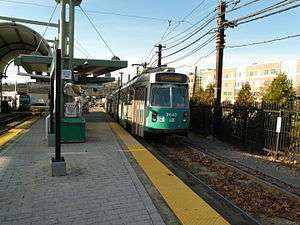 Green Line trains at Riverside in October 2011 | |||||||||||
| Location | 331 Grove Street off Route 128/I-95, Newton | ||||||||||
| Coordinates | 42°20′14″N 71°15′08″W / 42.3372°N 71.2521°WCoordinates: 42°20′14″N 71°15′08″W / 42.3372°N 71.2521°W | ||||||||||
| Owned by | Massachusetts Bay Transportation Authority | ||||||||||
| Line(s) | |||||||||||
| Platforms | 1 side platform, 1 island platform | ||||||||||
| Tracks | 2 | ||||||||||
| Connections |
| ||||||||||
| Construction | |||||||||||
| Parking |
925 spaces ($6.00 fee) 21 accessible spaces | ||||||||||
| Bicycle facilities | 48 spaces | ||||||||||
| Disabled access | Yes | ||||||||||
| History | |||||||||||
| Opened | 4 July 1959 | ||||||||||
| Traffic | |||||||||||
| Passengers (2011) | 2,241 (daily boardings)[1] | ||||||||||
| Services | |||||||||||
| |||||||||||
Riverside is the western terminus of the MBTA Green Line "D" Branch (Highland Branch) light rail line. It is located at 333 Grove Street, off Exit 22 on Interstate 95 (Route 128), in Auburndale, a village of Newton, Massachusetts. Scheduled travel time to Park Street is 46 minutes. Riverside includes a parking lot with spaces for 925 automobiles and bicycle parking. A loop allows trolleys to reverse direction for the trip back to Boston and storage tracks and the Riverside Carhouse are connected to the loop. The station is fully handicapped accessible.
Riverside station is home to a scale model of the dwarf planet Pluto in the Boston Museum of Science's community-wide solar system model.[2]
History

Through 1958, when the Highland Branch was served by the Boston and Albany Railroad, Riverside station was at the junction between the Highland Branch and the B&A main line. The MTA built a large commuter parking lot with a new brick station at the center and opened the branch to streetcar service on July 4, 1959. In 1995, new elevated platforms were built at the north end of the yard and the 1959-built station used as a bus terminal. The 1995-built platforms were raised slightly above track level; these made the station handicapped accessible when low-floor trolleys arrived in 2002.
Riverside is the only surface-level Green Line station aside from Lechmere with a prepayment (fare controlled) platform area. This allows passengers to board at all doors. Fare control began during morning peak hours only when the current platforms opened in 1995, and full-time in 2006 when the CharlieCard fare card system was introduced.
A track connection still exists with the main line (now the Framingham/Worcester Line); catenary is installed up to the junction for offloading trolleys delivered by the railroad onto the light rail network. On October 20, 1996, severe flooding overflowed the banks of the Muddy River and flooded the Green Line subway from the western portals to Boylston. From October 23 to 25, a commuter rail shuttle was run from a temporary platform at Riverside to South Station using the old track connection.[3]
On February 12, 2009, the MBTA authorized an 85-year lease of a portion of Riverside Station. A mixed-use development will be built on what are currently parking lots. As originally planned, this development will contain 420,000 sq ft (39,000 m2) of office space, 60,000 sq ft (5,600 m2) of retail space, and 190 residential units.[4] As of 2012, this project is still in the planning and approval stages.
In 2014, it was revealed by the state that Riverside would be the terminus of a proposed DMU Indigo Line to South Station, via the former track connection, but the plans were cancelled in 2015.[5][6]
Station layout
| P Platform level |
Outbound | ← "D" Branch termination track |
| Island platform, doors will open on the left | ||
| Inbound | → "D" Branch toward Government Center (Woodland) → | |
| Side platform, doors will open on the right | ||
| G | Ground Level | Fare control, parking |
Bus connections
One MBTA bus route, the 558 Riverside - Downtown Boston via Newton Corner & Turnpike, runs as a partial express to downtown Boston from Riverside. The 500 (discontinued) and 555 (cut back to Central Square, Waltham as the 553) routes formerly ran to Riverside as well.
Intercity bus services to and from Boston, including Greyhound Lines, Peter Pan Bus Lines, Go Buses, and Megabus offer occasional stops at Riverside. This service was temporarily suspended in early 2010 but was soon reinstated in October 2010.[7][8]
References
- ↑ "Ridership and Service Statistics" (PDF) (14 ed.). Massachusetts Bay Transportation Authority. 2014. Retrieved 23 November 2015.
- ↑ "Community Solar System Official Passport" (PDF). Boston Museum of Science. Retrieved 3 August 2011.
- ↑ Belcher, Jonathan (27 June 2015). "Changes to Transit Service in the MBTA district 1964-2015" (PDF). NETransit. Retrieved 23 November 2015.
- ↑ "Riverside Station Lease Approved". Massachusetts Bay Transportation Authority. 12 February 2009. Retrieved 3 August 2011.
- ↑ Annear, Steve (9 January 2014). "Take A Ride On The MBTA's 'New Indigo Line' In 2024". Boston Magazine. Retrieved 11 March 2014.
- ↑ Stout, Matt (20 June 2015). "Charlie Baker derails T trains". Boston Herald. Archived from the original on 27 July 2015.
- ↑ Thomas, Sarah (19 October 2010). "NYC-bound buses will roll from Newton and Cambridge". The Boston Globe. Retrieved 3 August 2011.
- ↑ "Riverside bus service reinstated". Wicked Local. 19 October 2010. Retrieved 3 August 2011.
External links
| Wikimedia Commons has media related to Riverside (MBTA station). |