Fairmount Line
FAIRMOUNT LINE | ||||||
|---|---|---|---|---|---|---|
|
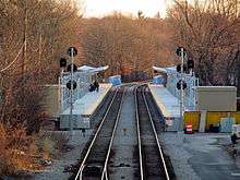
An outbound train at Talbot Ave station in 2012 | ||||||
| Overview | ||||||
| Type | Commuter rail line | |||||
| System | Massachusetts Bay Transportation Authority | |||||
| Status | Operating | |||||
| Locale | Eastern Massachusetts | |||||
| Termini |
Boston South Station Readville | |||||
| Stations |
8 active 1 planned | |||||
| Daily ridership | 1,038 (2013 weekday average)[1] | |||||
| Operation | ||||||
| Owner | MBTA | |||||
| Operator(s) | Keolis North America | |||||
| Character | Elevated and surface-level | |||||
| Technical | ||||||
| Line length | 9.2 mi (14.8 km) | |||||
| Track gauge | 4 ft 8 1⁄2 in (1,435 mm) | |||||
| ||||||

The Fairmount Line or Dorchester Branch is a line of the MBTA Commuter Rail system in Boston, Massachusetts, USA. Except for a short portion in Milton, it lies entirely within Boston, progressing in a southwesterly trajectory, passing through the neighborhoods of Dorchester, Mattapan and Hyde Park. Weekend service began on November 29, 2014.[2][3] Most trains reverse direction at the south end at Readville, but a few continue onto the Franklin Line.
From the 1980s until 2012, the Fairmount Line had only five stations - three plus the two termini (South Station and Readville); however, four more stations are being added to the line between 2012 and 2015. The first of these, Talbot Ave, opened on November 12, 2012, followed by Newmarket and Four Corners/Geneva on July 1, 2013.[4][5] Due to neighborhood opposition over its design and location, Blue Hill Avenue station has been delayed until December 2017.[2][6] All stations on the line are fully handicapped accessible.
The corridor currently serves mostly low-income and working-class communities.[7]
History
Former service

The line was built as an entrance to Boston for the Norfolk County Railroad and its successors, which originally had to rely on a connection via the Boston and Providence Railroad from Dedham. The new line, built in 1855, split from the old one at Islington and ran northeast, crossing the Boston and Providence Railroad at Readville. It continued on through Hyde Park and Dorchester before crossing the Old Colony Railroad at South Bay Junction. The line continued into South Boston and made a sweeping curve along a trestle west to downtown Boston and a terminal at Dewey Square.
After several failed reorganizations, the line became part of the New York and New England Railroad in 1873 and the New England Railroad in 1895. The New England was leased to the New York, New Haven and Hartford Railroad in 1898 and became their Midland Division. The line was operationally split at Readville, the crossing of the Boston and Providence (also leased by the NYNH&H), with many trains using the Midland from the southwest switching to the B&P, and some on the B&P from the south switching to the Midland.
In 1899, the new South Station union station opened, and a new set of tracks was built for the Midland on the west side of the Old Colony Railroad mainline, also part of the NYNH&H. The old South Boston station (located on West 1st Street between A and B Streets) was abandoned, being north of the junction with the new alignment, and the old terminal was no longer used, with the last bit of the old line (over Fort Point Channel) removed, and the rest used for freight only. South Boston was however served by the station that had been built for the Old Colony, now between the Old Colony and Midland tracks.
Under New Haven Railroad control, most intercity and some commuter trains from the former NY&NE (now the Franklin Line) switched onto the Northeast Corridor mainline (former B&P) at Readville, with Midland Branch service largely limited to local trains. Passenger service last ran on the Midland north of Readville in 1944 after a long period of declining ridership, though the line continued to be used for freight service to South Boston.
Restoration of passenger service

The MBTA bought the line (since merged into Penn Central) from Readville to Southampton Street in 1976 (the part south of Readville was bought in 1973 as part of the Franklin Line) and modernized it for use as a bypass while the mainline was closed during the Southwest Corridor project.[3] On November 3, 1979, all trains on the Franklin and Providence/Stoughton Lines, as well as Amtrak intercity service, were rerouted via the Midland.[3] Three of the old stations - Fairmount, Morton Street and Uphams Corner - were rebuilt with bare asphalt platforms and opened for local commuter service. The restored service on the line was not intended to be permanent; however, the service became locally popular.[8] Uphams Corner and Morton Street stations closed on January 30, 1981, as part of system-wide cuts that included the closure of the Woburn Branch.[3]
On October 5, 1987, the new Southwest Corridor opened to commuter service; most Franklin Line and Attleboro/Stoughton Line service was rerouted to the mainline. The MBTA began operating the Fairmount Shuttle (later known as the Fairmount Line) between South Station and Fairmount as a response to community demand; the stops at Morton Street and Uphams Corner were reopened. The shuttle was extended to Readville on November 30, 1987.[3] The route - sometimes called the Dorchester Branch by the MBTA - is used by some rush-hour Franklin Line trains to reduce load on the three-track Southwest Corridor and supplement the shuttle service. An MBTA study released in 2010 indicated that the most workable routing options for full-time service to Foxboro would involve extending some or all Fairmount Line trips to Foxboro over part of the Franklin Line.[9]
Some Providence/Stoughton Line trips used the Dorchester Branch until around 2004, when they were rerouted to the mainline to avoid passing through CSX's Readville 1-Yard. During disruptions on the Northeast Corridor north of Readville, Franklin and Providence service is sometimes diverted over the Fairmount Line.[10]
Improvement project


The Commonwealth of Massachusetts agreed in 2005 to make improvements on the Fairmount Line part of its legally binding commitment to mitigate increased air pollution from the Big Dig. To comply with the State Implementation Plan filed with the federal Environmental Protection Agency, these improvements must be complete by December 31, 2011. As an interim deadline, the Massachusetts Executive Office of Transportation was required to "complete final design, apply for all necessary permits and grants, file any required legislation, and initiate all public and private land acquisition" by December 1, 2009.[11]
The existing Uphams Corner and Morton Street stations have been rebuilt, featuring high-level train platforms for easy boarding, canopies, access ramps, electronic message boards, and pedestrian-friendly walkways. At the completion of the project, all stations on the line will be compliant with the Americans with Disabilities Act and be wheelchair-accessible.[12] Four new stations have been or will be constructed at Four Corners, Talbot Avenue, Blue Hill Avenue, and Newmarket Square. Additionally, six bridges have been reconstructed, a new interlocking was added, and the signal system has been rebuilt.[12]
The MBTA has allocated $37 million to the project and $39 million has been allocated from the Commonwealth from the Emergency Needs Bond Bill of 2007.[11] The total cost of the project is estimated at $79.4 million.[13]
The addition of new stations and the upgrades to the existing infrastructure are projected to divert 220 daily trips from automobiles to transit,[14] and increase daily weekday ridership on the line from around 2,800 to 7,300 one-way trips.[15]
The plan adopted by the MBTA is based on the Indigo Line plan advanced by community activists, which was intended to make the characteristics of the line more like rapid transit than commuter rail, with increased frequency and number of stops. However, in its initial proposal the MBTA did not plan to increase service frequency to match rapid transit lines, nor to install pre-pay fare systems. The Indigo Line plan also called for the use of diesel multiple unit (DMU) cars for faster acceleration and deceleration, which was considered by the MBTA but not implemented initially because of lack of funding. As of October 2014, the proposed state budget includes some funds to purchase DMU railcars and the state plans to issue a request for proposals in December to purchase 30 DMUs, with deliveries starting in 2018 and completed by 2020.[2]
The first new station to be completed, Talbot Ave, opened on November 12, 2012.[4] Newmarket and Four Corners/Geneva opened on July 1, 2013. Five new round trips were also added, and Fairmount station was changed to fare zone 1A (to reduce fares to the same as rapid transit) for two years as a pilot program.[16] Ribbon-cutting ceremonies were held at Newmarket, Four Corners/Geneva Ave, and Talbot Ave on July 17, 2013.[17]
The location and design of Blue Hill Avenue has been more controversial. A public meeting held in April 2014 showed mixed local opinions about the stations, with some nearby residents feeling that the stop was imposed on the neighborhood by the MBTA without sufficient public input.[18] At a later meeting, the MBTA presented a plan under which construction would begin in September 2015 for a June 2017 opening.[6] On October 16, 2014, the MBTA announced that construction of Blue Hill Avenue station will resume, with 100 percent design expected in spring 2015 and construction to start that November. The new station is expected to open in December 2017. The MBTA also then announced that hourly weekend service would begin on November 29, 2014 - the first weekend service on the line since passenger service was reintroduced in 1979.[2]
A pedestrian bridge was built between Ceylon and Bird Streets in the 1980s (during the initial restoration of the line) to prevent pedestrians from dangerously crossing the tracks. Although well-trafficked, the bridge deteriorated due to lack of maintenance and became unsafe; lighting was not replaced after persistent vandalism, and robberies were common. Residents field a petition with the MBTA in 2010, but no actions were taken until the MBTA closed the bridge outright in March 2014 due to its condition.[19][20] As of April 2014 no plan is in place to repair or replace the bridge, which may be difficult and expensive as the Americans with Disabilities Act of 1990 requries handicapped-accessible ramps. The City of Boston and the MBTA each claim the other is responsible for maintaining and funding the bridge.[21]
Station listing


All current and future stations are in Boston, Massachusetts, though a short portion of the line south of River Street including the location of the former Glenwood station is in Milton. All stations on the line are handicapped accessible. Readville and Fairmount have short high-level platforms long enough for one pair of doors, while the remaining stations have full-length high-level platforms. (See MBTA accessibility).
| Milepost[3][22] | Station | Opening date | Connections and notes |
|---|---|---|---|
| 0.0 | 1899 | Connections to Amtrak's Lake Shore Limited, Northeast Regional, and Acela Express; MBTA Commuter Rail Greenbush Line, Old Colony Lines, Providence/Stoughton Line, Needham Line, Franklin Line, and Framingham/Worcester Line; MBTA rapid transit Red Line and Silver Line | |
| 0.5 | South Boston | Closed; formerly located at West 4th Street | |
| 1.1 | South Bay Junction | never a station splits from Old Colony Lines (MBTA) before 1899, the line went northeast from here with a stop at South Boston and a terminal at the foot of Summer Street downtown | |
| 2.0 | July 1, 2013 | ||
| 2.2 | Cottage Street | Closed; separate from Uphams Corner station[8] | |
| 2.4 | November 3, 1979 | Formerly Dudley Street (pre-1944) | |
| 2.8 | Bird Street | Closed | |
| 3.5 | July 1, 2013 | Formerly Mount Bowdoin (pre-1944) | |
| 4.1 | Harvard Street | Closed | |
| 4.5 | November 12, 2012 | First station to open under the Fairmount Line Improvements program | |
| 4.7 | Dorchester | Closed; formerly located at Woodrow Avenue | |
| 5.3 | November 3, 1979 | originally Forest Avenue (pre-1944) | |
| 6.0 | December 2017 (planned)[2] | Originally Mattapan (pre-1944) In design, with construction to begin in 2015 for a 2017 opening | |
| 6.5 | Rugby | Closed; formerly located at Greenfield Road | |
| 6.8 | River Street | Closed | |
| 7.9 | November 3, 1979 | Sometimes (pre-1944) known as Hyde Park | |
| 8.3 | Glenwood | Closed; formerly located at Glenwood Avenue. Sometimes known as Fairmount | |
| 9.2 | splits with connections to the Franklin Line and the Providence/Stoughton Line |
References
- ↑ "2014 Bluebook 14th Edition" (PDF). Massachusetts Bay Transportation Authority. 2014. Retrieved 12 March 2015.
- 1 2 3 4 5 "Governor Patrick Announces Fairmount Line Service Upgrades". MassDOT Blog (Press release). Massachusetts Department of Transportation. 16 October 2014. Retrieved 17 October 2014.
- 1 2 3 4 5 6 Belcher, Jonathan (23 March 2013). "Changes to Transit Service in the MBTA district" (PDF). NETransit. Retrieved 8 January 2014.
- 1 2 Rocheleau, Matt (12 November 2012). "MBTA opens new commuter rail station at Talbot Avenue in Dorchester on Fairmount Line". Boston Globe. Retrieved 12 November 2012.
- ↑ Rocheleau, Matt (25 June 2013). "Commuter rail gives Fairmount a boost". Boston Globe. Retrieved 5 July 2013.
- 1 2 "Blue Hill Ave Station Design Meeting" (PDF). Massachusetts Bay Transportation Authority. 15 September 2014. Retrieved 2 October 2014.
- ↑ Fairmount/Indigo Line Coalition Comments on Fare Increase, 6/29/2006
- 1 2 KKO and Associates (15 October 2001). Fairmount Line Feasibility Study: Task One:Assessment of Existing Conditions (Draft). Massachusetts Bay Transportation Authority.
- ↑ Jacobs Engineering Group; Central Transportation Planning Staff; Gailbraith, Anne S. (1 September 2010). "Foxborough Commuter Rail Feasibility Study" (PDF). Massachusetts Bay Transportation Authority. Retrieved 8 January 2014.
- ↑ "Electrical fire delays MBTA Commuter Rail, Amtrak: Fire at Forest Hills station goes to 2-alarms". WCVB. 4 April 2015. Retrieved 7 April 2015.
Passengers using the Franklin and Providence lines to get into Boston are being diverted to the Fairmount line to get into the city, according to commuter rail officials.
- 1 2 "State Implementation Plan – Transit Commitments: Status Report" (PDF). Massachusetts Executive Office of Transportation. 2 July 2007. Retrieved 3 August 2011.
- 1 2 "Fairmount Line Improvements". Massachusetts Bay Transportation Authority. Retrieved 3 August 2011.
- ↑ Draft 2008-2013 MBTA Capital Improvement Plan, p. 128.
- ↑ 2004 MBTA Program for Mass Transportation, Appendix, Table C-15.
- ↑ Mac Daniel, "T To Begin Upgrade of Fairmount Rail Corridor," The Boston Globe, April 14, 2005
- ↑ Rocheleau, Matt (24 June 2013). "Fairmount commuter rail line to see service boost, some cheaper fares". Boston Globe. Retrieved 24 June 2013.
- ↑ "Patrick Administration Opens Three New Commuter Rail Stations". Massachusetts Bay Transportation Authority. 17 July 2013. Retrieved 17 July 2013.
- ↑ "Everything Was Quiet & Business-like at Mattapan Transpo Meeting, And Then .....". Here and Sphere. 11 April 2014. Retrieved 13 April 2014.
- ↑ Rosso, Patrick (19 December 2013). "Poor conditions persist at rusting Ceylon Street bridge". Boston Globe. Retrieved 28 July 2015.
- ↑ Rosso, Patrick (6 March 2014). "Ceylon Street bridge closed by T; future unknown". Boston Globe. Retrieved 28 July 2015.
- ↑ Powers, Martine (12 April 2014). "No solution in sight for Roxbury footbridge". Boston Globe. Retrieved 28 July 2015.
- ↑ Leo S. (26 December 2009). "Railroad Stations in Dorchester". Dorchester Atheneum. Retrieved 8 January 2014.
External links
| Wikimedia Commons has media related to MBTA Fairmount Line. |
| Subway lines (List of stations) |
| |||||||||||
|---|---|---|---|---|---|---|---|---|---|---|---|---|
| Commuter Rail lines (List of stations) |
| |||||||||||
| Bus routes (List of routes) | ||||||||||||
| Other services | ||||||||||||
| Component parts of system lines | ||||||||||||
| Capital projects |
| |||||||||||
| History |
| |||||||||||
| Other | ||||||||||||