Boylston (MBTA station)
BOYLSTON
BOYLSTON | ||||||||||||||||||||||||||||||||||||||||||||||
|---|---|---|---|---|---|---|---|---|---|---|---|---|---|---|---|---|---|---|---|---|---|---|---|---|---|---|---|---|---|---|---|---|---|---|---|---|---|---|---|---|---|---|---|---|---|---|
 Inbound platform at Boylston in 2012 | ||||||||||||||||||||||||||||||||||||||||||||||
| Location |
Boylston Street at Tremont Street Boston, Massachusetts | |||||||||||||||||||||||||||||||||||||||||||||
| Coordinates | 42°21′09″N 71°03′53″W / 42.35250°N 71.06472°WCoordinates: 42°21′09″N 71°03′53″W / 42.35250°N 71.06472°W | |||||||||||||||||||||||||||||||||||||||||||||
| Owned by | MBTA | |||||||||||||||||||||||||||||||||||||||||||||
| Line(s) | ||||||||||||||||||||||||||||||||||||||||||||||
| Platforms | 2 island platforms (used as side platforms) | |||||||||||||||||||||||||||||||||||||||||||||
| Tracks | 4 (2 used) | |||||||||||||||||||||||||||||||||||||||||||||
| History | ||||||||||||||||||||||||||||||||||||||||||||||
| Opened |
September 3, 1897 (Green Line) July 30, 2002 (Silver Line) | |||||||||||||||||||||||||||||||||||||||||||||
| Traffic | ||||||||||||||||||||||||||||||||||||||||||||||
| Passengers (2013) | 6,826 (weekday average boardings)[1] | |||||||||||||||||||||||||||||||||||||||||||||
| Services | ||||||||||||||||||||||||||||||||||||||||||||||
| ||||||||||||||||||||||||||||||||||||||||||||||
Boylston is a light rail station on the MBTA Green Line system, and is located on the southeast corner of Boston Common at the intersection of Boylston Street and Tremont Street. Boylston opened along with Park Street in 1897 as the first subway stations in North America. After more than a century of continuous operation, Boylston station retains an appearance more like its original look than any other station in the MBTA system.
Boylston station serves as a stop on the bus rapid transit Silver Line, with a southbound stop at street level. Construction of a proposed underground Silver Line station at this location has been postponed indefinitely.
Boylston is not handicapped accessible. Nearby Park Street, Chinatown, and Arlington stations are fully accessible.
Location
Boylston station is located at the intersection of Boylston Street and Tremont Street in southern Downtown Boston, slightly to the east of the Back Bay neighborhood. Boylston's central location places it near many important Boston landmarks and points-of-interest. The southeastern corner of Boston Common and the northeastern corner of Emerson College are located at the intersection of Boylston Street and Tremont Street. Boylston is the closest Green Line station to the Washington Street Theatre District and Boston's Chinatown.
Boston's Chinatown is directly east of the station, and the Chinatown station on the Orange Line, only a block east at Washington Street, took its name from the neighborhood in 1987; one platform had earlier been named "Boylston" as well.
History

Boylston and Park Street were the first two stations built in the Tremont Street Subway. The subway was constructed between 1895 and 1897, and first broke ground on the site of the current Boylston station. When the station opened in 1897, it became the first underground rapid transit station in the United States.[2] Of the two original stations, Boylston retains more of its original appearance, having undergone only minimal changes in over a century of continuous operation. In 1964, the Tremont Street Subway, including Boylston station, was designated a National Historic Landmark.
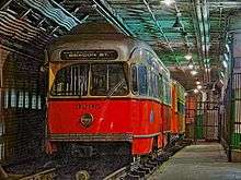
Historic Boston trolleys (PCC #3295 and Type 5 #5734) are sometimes kept on display in the station. Both are operable and were used for rail fan trips until 1990 and 1998.[3] The trolleys are parked on a set of outer tracks leading to a tunnel continuing southward under Tremont Street and heading to the old Pleasant Street Incline. Boylston station once connected via this tunnel to the Incline and a portal located in what is now Eliot Norton Park, immediately east of the Bay Village neighborhood of Boston. From the portal, several trolley lines diverged, including service through to South Boston via Broadway station. The trolley service was discontinued in 1962, the route was converted to buses, and the portal was later covered by construction of the park.[4]
During the summer of 2006, the MBTA installed brighter lighting at Boylston station, changing the previously dim appearance of the underground space. Modern electronic faregates and fare vending machines have also been installed.
Some of the proposals for completing Phase III of the Silver Line had involved reopening portions of the tunnel for direct connections to the Boylston Green Line station. As of 2010, all proposals for Phase III tunnel construction have been postponed indefinitely, due to lack of funding, and heavy community opposition.
Incidents and accidents
A few months before the station opened, there was a gas explosion at the corner of Tremont and Boylston Streets on 4 March 1897. Gas had been escaping from an underground main for two months into the gap between the station's roof and the street above, before a horse-drawn trolley caused a spark which ignited the gas. Witnesses reported that a fireball engulfed the trolley, and burned several people and horses instantly. Six persons were killed, and at least sixty were seriously injured. The station was spared any serious damage, as much of the force of the blast had radiated upward.[5]
On 6 June 1906, there was another explosion at Boylston station.[6] The origin of the explosion was deemed to be the short-circuiting of the overhead lines in the station which began to burn and catch fire.[6] Because of the electrical nature of the fire, spraying water to stop the flames failed and fire-fighters who attempted to do so were met with electric shocks. Only three people were injured, and the fire extinguished itself.[6]
On 15 November 2008, two Green Line trains collided at the northbound platform of Boylston station.[7] Although the cars themselves were not visibly damaged, a few passengers complained about neck and back pains and were sent to the hospital.[7] A few hours later, the Green Line re-opened between Arlington and Government Center stations and temporary buses stopped running.[7]
On 29 November 2012, two trolleys collided at low speed at Boylston, injuring several dozen passengers.[8] The collision was blamed on a fatigued trolley driver who had not had enough rest following his second job.[9]
Station layout

| Ground | Street Level | Exit/Entrance |
| Outbound | ← Silver Line toward Dudley Square (Tufts Medical Center) | |
| Green Line platforms |
Unused track | No regular service |
| Side platform (offset to north), doors will open on the right | ||
| Outbound | ← Green Line toward Boston College, Cleveland Circle, Riverside, or Heath (Arlington) | |
| Inbound | → Green Line toward Lechmere, North Station, Government Center, or Park Street (Park Street) → | |
| Side platform (offset to south), doors will open on the right | ||
| Unused track | No regular service | |

Boylston was originally configured for four tracks with two island platforms (see diagram), and the original track layout has remained essentially unchanged since then. The two outer tracks formerly led to the Pleasant Street Portal, but are no longer in revenue service, have been fenced off, and are now used for storage and other miscellaneous purposes.[10] Two former streetcars – one of the Boston Elevated Railway and one of the old M.T.A. (predecessor of the MBTA) – are usually displayed on the outer track of the inbound platform, along with explanatory signage. An old work train car is usually stored on the other outer track.
There is no free crossover between the platforms; thus passengers must pay attention to signs at street level denoting the separate entrances to the inbound and outbound platforms. A former crossover passage was sealed decades ago for security reasons. However, free crossovers are possible at the next station in either direction (either Park Street or Arlington).
Rail squeal
The Green Line takes a sharp right-angle turn just south of Boylston station, as it turns from Tremont Street onto Boylston Street. The tight radius of curvature of the track can cause loud squealing noises from the train wheels, which are audible at street level near the station entrance at the corner. When the MBTA buys new streetcars, they must be designed to make this extremely tight curve without derailing.
References
- ↑ "Ridership and Service Statistics" (PDF) (14 ed.). Massachusetts Bay Transportation Authority. 2014. Archived from the original (PDF) on 12 September 2014. Retrieved 25 June 2014.
- ↑ Boston's subway finished The New York Times (August 15, 1897) Retrieved 2008-11-28
- ↑ "ALL TIME FANTRIP LISTING" (PDF). Boston Street Railway Association. Retrieved 2 April 2016.
- ↑ Bierman, Noah, "Transit archeology: Tour of abandoned subway network offers a glimpse of how the T was built", The Boston Globe, Saturday, December 26, 2009.
- ↑ "Tremont Street Gas Explosion, 1897". Celebrate Boston. CelebrateBoston.com. Retrieved 2014-06-28.
- 1 2 3 Boston subway explosion The New York Times Retrieved 2008-11-28
- 1 2 3 Trolley crash snarls Green Line rush hour The Boston Globe Retrieved 2008-11-28
- ↑ Moskowitz, Erik; et al. (29 November 2012). "35 taken to hospital after two trolleys collide at Boylston MBTA station". Boston Globe. Retrieved 29 November 2012.
- ↑ Moskowitz, Eric & Finucane, Martin (5 December 2012). "MBTA fires trolley operator in Green Line crash at Boylston Station for being fatigued and 'inattentive'". The Boston Globe. Retrieved 5 December 2012.
- ↑ MBTA Green Line subway NYCSubway Retrieved 2008-11-28
External links
| Wikimedia Commons has media related to Boylston (MBTA station). |
| Subway lines (List of stations) |
| |||||||||||
|---|---|---|---|---|---|---|---|---|---|---|---|---|
| Commuter Rail lines (List of stations) |
| |||||||||||
| Bus routes (List of routes) | ||||||||||||
| Other services | ||||||||||||
| Component parts of system lines | ||||||||||||
| Capital projects |
| |||||||||||
| History |
| |||||||||||
| Other | ||||||||||||