Orange Line (MBTA)
ORANGE LINE | |
|---|---|
|
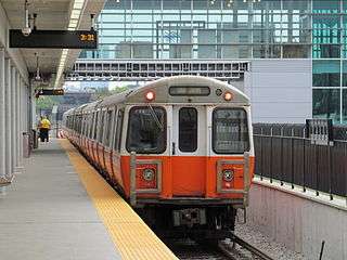
Inbound train at Assembly on its opening day in September 2014 | |
| Overview | |
| Type | Rapid transit |
| Status | Operational |
| Locale | Boston, Massachusetts |
| Termini |
Oak Grove Forest Hills |
| Stations | 20 |
| Daily ridership | 203,406 (2013)[1] |
| Operation | |
| Opened | 1901 |
| Owner | MBTA |
| Operator(s) | MBTA |
| Rolling stock | 01200 series |
| Technical | |
| Line length | 11 miles (18 km) |
| Track gauge | 4 ft 8 1⁄2 in (1,435 mm) |
| Electrification | Third rail |
The Orange Line is one of the four subway lines of the Massachusetts Bay Transportation Authority. It extends from Forest Hills in Jamaica Plain, Boston in the south to Oak Grove in Malden in the north. It meets the Red Line at Downtown Crossing, the Blue Line at State, and the Green Line at Haymarket and North Station. It connects with Amtrak service at Back Bay and North Station, and with MBTA Commuter Rail service at Back Bay, North Station, Forest Hills, Ruggles station in Roxbury, and Malden Center in Malden. From 1901 to 1987, it provided the first elevated rapid transit in Boston; the last elevated section was torn down in 1987 when the southern portion of the line was moved to the Southwest Corridor.
All stations on the Orange Line are handicapped accessible. These stations are equipped with high-level platforms for easy boarding, as well as elevators for easy platform access.
History
Construction

The Main Line of the electric Boston Elevated Railway opened in segments, starting in 1901. It proceeded from Sullivan Square along the Charlestown Elevated to the Canal Street Incline near North Station. It was carried underground by the Tremont Street Subway (now part of the Green Line), returning above ground at the Pleasant Street Incline (now closed, located just south of Boylston station). A temporary link connected from there to the Washington Street Elevated, which in 1901 ran from this point via Washington Street to Dudley Square (which is most of what is now Phase 1 of the Silver Line).
Also in 1901, the Atlantic Avenue Elevated opened, branching at Causeway Street to provide an alternate route through downtown Boston (along the shoreline, where today there is no rail transit) to the Washington Street Elevated.
In 1908, a new Washington Street Tunnel opened, allowing Main Line service to travel from the Charlestown Elevated, underground via an additional new portal at the Canal Street Incline, under downtown Boston and back up again to meet the Washington Street Elevated and Atlantic Avenue Elevated near Chinatown. Use of the parallel Tremont Street Subway was returned exclusively to streetcars.
By 1909, the Washington Street Elevated had been extended south to Forest Hills. Trains from Washington Street were routed through the new subway, either all the way to Sullivan Square, or back around in a loop via the subway and then the Atlantic Avenue Elevated.
In 1919, the Charlestown Elevated was extended north from Sullivan Square to Everett, over surface right-of-way parallel to Alford Street/Broadway, with a drawbridge over the Mystic River.[2] The Boston Elevated had long-term plans to continue this extension further north to Malden, a goal which would only be achieved decades later, under public ownership and not via the Everett route.
Closure of Atlantic Avenue Elevated and ownership changes
.jpg)
Following a 1928 accident at a tight curve on Beach Street, the southern portion of the Atlantic Avenue Elevated, between South Station and Tower D on Washington Street, was closed (except for rush-hour trips from Dudley to North Station via the Elevated), breaking the loop; non-rush-hour Atlantic Avenue service was reduced to a shuttle between North and South Stations.[2] In 1938, the remainder of the Atlantic Avenue Elevated was closed, leaving the subway as the only route through downtown - what is now the Orange Line between Haymarket and Chinatown stations.
Ownership of the railway was transferred from the private Boston Elevated Railway to the public Metropolitan Transit Authority (MTA) in 1947; the MTA was itself reconstituted as the modern Massachusetts Bay Transportation Authority (MBTA) in 1964.
Orange Line naming
.jpg)
The line was known as the Main Line Elevated under the Boston Elevated Railway, and the Forest Hills–Everett Elevated (Route 2 on maps) under the Metropolitan Transportation Authority.
After taking over operations in August 1964, the MBTA began rebranding many elements of Boston's public transportation network. On August 26, 1965, the four rapid transit lines were assigned colored names related to their history and geography. The Elevated became the Orange Line after Orange Street, an old name for the section of Washington Street immediately south of downtown, under which the Washington Street Tunnel runs.[3][4] When designing the rebranding, Cambridge Seven Associates originally planned for yellow instead of orange, but yellow was rejected after testing.[5]
In January and February 1967, the four original Washington Street Tunnel stations were renamed. Transfer stations were given the same name for all lines: Winter and Summer stations plus Washington on the Red Line became Washington, Milk and State plus Devonshire on the Blue Line became State Street after the cross street, and Union and Friend plus Haymarket Square on the Green Line became Haymarket after Haymarket Square.[2] Boylston Street was renamed Essex to avoid confusion with nearby Boylston station on the Green Line.[2]
In May 1987, Essex was renamed Chinatown after the adjacent Chinatown neighborhood, and Washington renamed Downtown Crossing after the adjacent shopping district.[2] In March 2010, New England Medical Center station was renamed as Tufts Medical Center two years after the eponymous hospital changed its name.[2]
Rerouting of Charlestown and Everett service

The Boston Transportation Planning Review looked at the line in the 1970s, considering extensions to reach the beltway Route 128, with termini at Reading in the north and Dedham in the south. As a result of this review, the Charlestown Elevated - which served the Charlestown neighborhood north of downtown Boston and the inner suburb Everett - was demolished and replaced in 1975.
The Haymarket North Extension rerouted the Orange Line through an underwater crossing of the Charles River. Service in Charlestown was replaced with service along Boston and Maine tracks routed partially beneath an elevated section of Interstate 93, ultimately to Wellington and then to Oak Grove in Malden, Massachusetts instead of Everett. Rail service to Everett was replaced with buses.
Closure of Washington Street Elevated

Construction of Interstate 95 into downtown Boston was cancelled in 1972 after local protest over the necessary demolition. However, land for I-95's Southwest Corridor through Roxbury had already been cleared of buildings; moreover, the state had already committed to using this vacant land for transportation purposes.[6] As a result, instead of an 8-lane Interstate highway with a relocated Orange Line running in its median (in a manner similar to the Chicago Transit Authority's Dan Ryan and Congress and Jefferson Park lines), the space would be occupied by the realigned Orange Line, a reconstructed three-track mainline for Amtrak's Northeast Corridor and MBTA Commuter Rail trains, and a linear park. After this re-routing was accomplished in 1987, the Washington Street Elevated was torn down, the last major segment of the original elevated line to be demolished.

Between April 30 and May 3, 1987, the Washington Street Elevated south of the Chinatown station was closed to allow the Orange Line to be tied into the new Southwest Corridor. On May 4, 1987, the Orange Line was rerouted from the southern end of the Washington Street Tunnel onto the new Southwest Corridor. Instead of rising up to elevated tracks, it now veered west at the Massachusetts Turnpike and followed the Pike and the old Boston and Albany Railroad right-of-way to the existing MBTA Commuter Rail stop at Back Bay. It then continued along new tracks, partially covered and partially open but depressed, to Forest Hills. This MBTA right-of-way is also shared by Amtrak as part of the national Northeast Corridor intercity passenger rail service.
|
|
While ending more or less at the same terminus (Forest Hills), the new routing bypassed significantly to the west of its previous route on Washington Street; local residents were promised replacement service. Originally, plans provided for light rail vehicles street running in mixed traffic, from Washington Street to Dudley Square, then diverting southeastward on Warren Street towards Dorchester. In 2002, Phase 1 of the Silver Line bus rapid transit was added to connect Washington Street to the downtown subways, attempting to address this service need. This replacement service was controversial, as many residents preferred the return of rail transportation.
Renovations during the Big Dig
Haymarket and North Station received major renovations during the Big Dig in the 1990s and first decade of the 21st century, as the Causeway Street Elevated portion of the Green Line was buried, its physical connection to the Orange Line was improved to make transfers easier, the Canal Street Incline was finally closed, and the Green Line was re-rerouted through a new portal closer to the river, near the Zakim Bunker Hill Bridge.
Assembly

In the early 2000s, Somerville began planning an infill station between Sullivan and Wellington to serve the new Assembly Square development. The $57 million station was funded by the state's Executive Office of Housing and Economic Development, FTA Section 5309 New Starts program, and Federal Realty Investment Trust (the developer of Assembly Square).[8] Construction began in late 2011 and finished in mid 2014.[9] The new station, Assembly, opened on September 2, 2014.[10] It was the first new station on the MBTA subway system since 1987.[10]
Winter issues and resiliency work
During the unusually brutal winter of 2014-2015, the entire MBTA system was shut down on several occasions by heavy snowfalls. The aboveground sections of the Orange and Red lines were particularly vulnerable due to their exposed third rail, which iced over during storms. When a single train stopped due to power loss, other trains soon stopped as well; without continually running trains pushing snow off the rails, the lines were quickly covered in snow. (Because the Blue Line was built with overhead lines on its surface section due to its proximity to corrosive salt air, it was not subject to icing issues.)
During 2015, the MBTA is implementing its $83.7 million Winter Resiliency Program, much of which focused on preventing similar issues with the Orange and Red lines. The Southwest Corridor section of the Orange Line is located in a trench and is protected from the worst weather, but the 1970s-built Haymarket North Extension had older infrastructure and was in worse shape. From Sullivan Square north, it is exposed to the weather and largely built on an embankment, rendering it more vulnerable. That section is receiving new heated third rail, switch heaters, and snow fences to reduce the impacts of inclement weather.[11][12] The work requires bustitution of the line from Sullivan Square to Oak Grove on many weeknights.[13]
Historical routes
| Route diagram templates of the various Orange Line routes over its history | |||||||||||||||||||||||||||||||||||||||||||||||||||||||||||||||||||||||||||||||||||||||||||||||||||||||||||||||||||||||||||||||||||||||||||||||||||||||||||||||||||||||||||||||||||||||||||||||||||||||||||||||||||||||||||||||||||||||||||||||||||||||||||||||||||||||||||||||||||||||||||||||||||||||||||||||||||||||||||||||||||||||||||||||||||||||||||||||||||||||||||||||||||||||||||||||||||||||||||||||||||||||||||||||||||||||||||||||||||||||||||||||||||||||||||||||||||||||||||||||||||||||||||||||||||||||||||||||||||||||||||||||||||||||||||||||||||||||||||||||||||||||||||||||||||||||||||||||||||||||||||||||||||||||||||||||||||||||||||||||||||||||||||||||||||||||||||||||||||||||||||||||||||||||||||||||||||||||||||||||||||||||||||||||||||||||||||||||||||||||||||||||||||||||||
|---|---|---|---|---|---|---|---|---|---|---|---|---|---|---|---|---|---|---|---|---|---|---|---|---|---|---|---|---|---|---|---|---|---|---|---|---|---|---|---|---|---|---|---|---|---|---|---|---|---|---|---|---|---|---|---|---|---|---|---|---|---|---|---|---|---|---|---|---|---|---|---|---|---|---|---|---|---|---|---|---|---|---|---|---|---|---|---|---|---|---|---|---|---|---|---|---|---|---|---|---|---|---|---|---|---|---|---|---|---|---|---|---|---|---|---|---|---|---|---|---|---|---|---|---|---|---|---|---|---|---|---|---|---|---|---|---|---|---|---|---|---|---|---|---|---|---|---|---|---|---|---|---|---|---|---|---|---|---|---|---|---|---|---|---|---|---|---|---|---|---|---|---|---|---|---|---|---|---|---|---|---|---|---|---|---|---|---|---|---|---|---|---|---|---|---|---|---|---|---|---|---|---|---|---|---|---|---|---|---|---|---|---|---|---|---|---|---|---|---|---|---|---|---|---|---|---|---|---|---|---|---|---|---|---|---|---|---|---|---|---|---|---|---|---|---|---|---|---|---|---|---|---|---|---|---|---|---|---|---|---|---|---|---|---|---|---|---|---|---|---|---|---|---|---|---|---|---|---|---|---|---|---|---|---|---|---|---|---|---|---|---|---|---|---|---|---|---|---|---|---|---|---|---|---|---|---|---|---|---|---|---|---|---|---|---|---|---|---|---|---|---|---|---|---|---|---|---|---|---|---|---|---|---|---|---|---|---|---|---|---|---|---|---|---|---|---|---|---|---|---|---|---|---|---|---|---|---|---|---|---|---|---|---|---|---|---|---|---|---|---|---|---|---|---|---|---|---|---|---|---|---|---|---|---|---|---|---|---|---|---|---|---|---|---|---|---|---|---|---|---|---|---|---|---|---|---|---|---|---|---|---|---|---|---|---|---|---|---|---|---|---|---|---|---|---|---|---|---|---|---|---|---|---|---|---|---|---|---|---|---|---|---|---|---|---|---|---|---|---|---|---|---|---|---|---|---|---|---|---|---|---|---|---|---|---|---|---|---|---|---|---|---|---|---|---|---|---|---|---|---|---|---|---|---|---|---|---|---|---|---|---|---|---|---|---|---|---|---|---|---|---|---|---|---|---|---|---|---|---|---|---|---|---|---|---|---|---|---|---|---|---|---|---|---|---|---|---|---|---|---|---|---|---|---|---|---|---|---|---|---|---|---|---|---|---|---|---|---|---|---|---|---|---|---|---|---|---|---|---|---|---|---|---|---|---|---|---|---|---|---|---|---|---|---|---|---|---|---|---|---|---|---|---|---|---|---|---|---|---|---|---|---|---|---|---|---|---|---|---|---|---|---|---|---|---|---|---|---|---|---|---|---|---|---|---|---|---|---|---|---|---|---|---|---|---|---|---|---|---|---|---|---|---|---|---|---|---|---|---|---|---|---|---|---|---|---|---|---|---|---|---|---|---|---|---|---|---|---|---|---|---|---|---|---|---|---|---|---|---|---|---|---|---|---|---|---|---|---|---|---|---|---|---|---|---|---|---|---|---|---|---|---|---|---|---|---|---|---|---|---|---|---|---|---|---|---|---|---|---|---|---|---|---|---|---|---|---|---|---|---|---|---|---|---|---|---|---|---|---|---|---|---|---|---|---|---|---|---|---|---|---|---|---|---|---|---|---|---|---|---|---|---|---|---|---|---|---|---|---|---|---|---|---|---|---|---|---|---|---|---|---|---|---|---|---|---|---|
| |||||||||||||||||||||||||||||||||||||||||||||||||||||||||||||||||||||||||||||||||||||||||||||||||||||||||||||||||||||||||||||||||||||||||||||||||||||||||||||||||||||||||||||||||||||||||||||||||||||||||||||||||||||||||||||||||||||||||||||||||||||||||||||||||||||||||||||||||||||||||||||||||||||||||||||||||||||||||||||||||||||||||||||||||||||||||||||||||||||||||||||||||||||||||||||||||||||||||||||||||||||||||||||||||||||||||||||||||||||||||||||||||||||||||||||||||||||||||||||||||||||||||||||||||||||||||||||||||||||||||||||||||||||||||||||||||||||||||||||||||||||||||||||||||||||||||||||||||||||||||||||||||||||||||||||||||||||||||||||||||||||||||||||||||||||||||||||||||||||||||||||||||||||||||||||||||||||||||||||||||||||||||||||||||||||||||||||||||||||||||||||||||||||||||
Station listing
| Station | Time to Downtown Crossing (min)[1] |
Opened | Transfers and notes |
|---|---|---|---|
| 16 | March 20, 1977 | ||
| 14 | December 27, 1975 | Commuter Rail: Haverhill/Reading Line | |
| 11 | September 6, 1975 | ||
| 10 | September 2, 2014 | Infill station | |
| 8 | April 7, 1975 | Separate station from one on the Charlestown Elevated closed April 4, 1975 | |
| 6 | April 7, 1975 | Serves Bunker Hill Community College | |
| 4 | April 7, 1975 | Green Line and Commuter Rail north side lines. Amtrak: Downeaster | |
| 3 | November 30, 1908 | Green Line Originally Friend-Union until January 25, 1967 | |
| 2 | November 30, 1908 | Blue Line Originally Milk-State until January 24, 1967 | |
| - | November 30, 1908 | Red Line, Green Line and Silver Line Originally Winter-Summer until January 22, 1967, then Washington until May 3, 1987 | |
| 2 | November 30, 1908 | Silver Line Originally Boylston-Essex until February 10, 1967, then Essex until May 3, 1987 | |
| 3 | May 4, 1987 | Silver Line Originally New England Medical Center until April 2010 | |
| 5 | May 4, 1987 | Amtrak: Acela Express, Northeast Regional and Lake Shore Limited Commuter Rail: Providence/Stoughton Line, Framingham/Worcester Line, Franklin Line and Needham Line Also called Back Bay/South End | |
| 7 | May 4, 1987 | ||
| 9 | May 4, 1987 | Commuter Rail: Providence/Stoughton Line, Franklin Line and Needham Line | |
| 11 | May 4, 1987 | ||
| 13 | May 4, 1987 | ||
| 14 | May 4, 1987 | ||
| 16 | May 4, 1987 | Separate station from one on the former Washington Street Elevated closed April 30, 1987 | |
| 18 | May 4, 1987 | Commuter Rail: Needham Line Separate station from one on the former Washington Street Elevated closed April 30, 1987 Former terminus of Green Line E branch |
Rolling stock

The "T" previously had a fleet of Pullman-Standard heavy rail cars for the Orange Line. These cars, known as 01100s, had been in service since the 1950s, and saw service on both the elevated and the northern extension before they were retired in 1981. Several remained on the property for some time before being scrapped. The 01100 cars were a favorite for fans, as the small motorman's cab enabled passengers to stand at the front for an operator's-eye view.
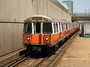
The Orange Line is standard gauge heavy rail and uses a third rail for power. The current fleet is the 01200 series, built between 1979 and 1981 by Hawker Siddeley Canada Car and Foundry (now Bombardier Transportation) of Thunder Bay, Ontario, Canada. They are 65 feet (20 m) long and 9 ft 3 in (2.8 m) wide, with three pairs of doors on each side. They are based on the PA3 model used by PATH in New Jersey. There are 120 cars, numbered 01200-01319. All in-service Orange Line trains run in six-car configurations.
| Year Built | Make | Model | Length ft ( mm) | Width in ( mm) | Gauge | Road Numbers |
|---|---|---|---|---|---|---|
| 1979–1981 | Hawker Siddeley Canada | PA3 | 65 ft (19,812 mm) | 111 in (2,819 mm) | 4 ft 8 1⁄2 in (1,435 mm) | 1200–1319 |
New trains
In late 2008, the MBTA began the planning process for new Orange and Red Line vehicles. The agency planned for a simultaneous order for 146 Orange Line cars (to replace the whole fleet) and 74 Red Line cars (to replace the older 1500 and 1600 series cars). A similar order was used in the late 1970s for the current Orange Line cars and the old Blue Line cars, ordered at the same time and largely identical except for size.[14] In October 2013, MassDOT announced plans for a $1.3 billion subway car order for the Orange and Red Lines, which would provide 152 new cars to replace the current 120-car fleet and add more frequent service.[15]
On October 22, 2014, the MassDOT Board awarded Chinese manufacturer CNR a $566.6 million contract to build 152 replacement railcars for the Orange Line, as well as additional cars for the Red Line.[16] CNR will build the Type B cars at a new manufacturing plant in Springfield, Massachusetts, with initial deliveries expected in 2018 and all cars in service by 2023.[16] In conjunction with the new rolling stock, the remainder of the $1.3 billion allocated for the project will pay for testing, signal improvements and expanded maintenance facilities, as well as other related expenses.[16]
While waiting for new cars, service has deteriorated due to maintenance problems with the old cars. The number of trains at rush hour was reduced from 17 (102 cars) to 16 (96 cars) in 2011; in the same year, daily ridership surpassed 200,000.[17] Increased running times - largely due to longer dwell times from increased ridership - resulted in headways being lengthened from 5 minutes before 2011 to 6 minutes in 2016. The increased fleet size with the new trains will allow headways to be reduced to 4 to 5 minutes at peak.[18] In the interim, a 2016 test of platform markings at North Station which show boarding passengers where to stand to avoid blocking alighting passengers, resulted in a one-third decrease in dwell times.[19]
Facilities
The Orange Line has two tracks (one in each direction) and a third track between Wellington and the Charles River portal.[20] This track is used to bypass construction on the other two, and for testing newly delivered cars for the Orange and Blue lines. The primary maintenance and storage facility is at Wellington Station.[20] Had the Orange Line been extended to Reading, the third track would have been the northbound local track and the present-day northbound track would have become the express track.
References
- 1 2 "Ridership and Service Statistics" (PDF) (14 ed.). Massachusetts Bay Transportation Authority. 2014. Retrieved 1 August 2014.
- 1 2 3 4 5 6 Belcher, Jonathan (27 June 2015). "Changes to Transit Service in the MBTA district" (PDF). NETransit. Retrieved 5 August 2015.
- ↑ Sanborn, George M. (1992). A Chronicle of the Boston Transit System. Massachusetts Bay Transportation Authority – via MIT.
- ↑ "Curiosity Carcards" (PDF). Massachusetts Bay Transportation Authority.
- ↑ Tran, Andrew Ba (June 2012). "MBTA Orange Line's 111th anniversary". Boston Globe. p. 11. Retrieved 19 January 2016.
- ↑ Anderson, Steve. "Southwest Expressway (I-95, unbuilt)". bostonroads.com. Retrieved 3 August 2013.
- ↑ "Orange Line El Stations". Boston TV Digital News. WGBH. April 30, 1987. Retrieved September 15, 2016.
- ↑ Moskowitz, Eric (6 October 2011). "MBTA board OK's millions for stations". Boston Globe. Retrieved 7 October 2011.
- ↑ Coughlin, Kerri (25 October 2011). "Construction on Assembly Square T stop to begin later this fall". Tufts Daily. Archived from the original on 4 December 2011. Retrieved 13 June 2012.
- 1 2 Hofherr, Justine (27 August 2014). "Somerville's New Assembly Square MBTA Station to Open Next Week". Boston Globe. Retrieved 27 August 2014.
- ↑ Vaccaro, Adam (23 September 2015). "Winter is coming, and the MBTA is getting ready". Boston Globe. Retrieved 4 October 2015.
- ↑ "Gov. Baker Announces $83.7 Million MBTA Winter Resiliency Plan" (Press release). Massachusetts Bay Transportation Authority. 4 June 2015.
- ↑ "Winter Resiliency Work Continues on the Red Line: WEEKEND TRAIN SERVICE BETWEEN JFK/UMASS AND QUINCY CENTER SUSPENDED" (Press release). Massachusetts Bay Transportation Authority. 9 September 2015.
- ↑ Central Transportation Planning Staff (December 2009). "CHAPTER 5: Priorities for Achieving a State of Good Repair" (PDF). The Program for Mass Transportation. Massachusetts Bay Transportation Authority. p. 5-2.
- ↑ "Governor Patrick Announces Major Transportation Funding Investments" (Press release). Massachusetts Bay Transportation Authority. 22 October 2013. Retrieved 22 October 2013.
- 1 2 3 "Chinese Company Hopes MBTA Contract Will Be U.S. Launching Pad". WMUR.com. October 22, 2014. Archived from the original on October 22, 2014. Retrieved October 23, 2014.
- ↑ Dungca, Nicole (8 June 2016). "Your Orange Line commute is more crowded than it used to be.". Boston Globe. Retrieved 8 June 2016.
- ↑ "MBTA State of the Service: Orange Line Heavy Rail" (PDF). Massachusetts Bay Transportation Authority. 6 June 2016. p. 26.
- ↑ Vaccaro, Adam (6 June 2016). "Why Orange Line trains are leaving North Station a little bit faster now". Boston Globe. Retrieved 8 June 2016.
- 1 2 "MBTA Orange Line". world.nycsubway.org. Retrieved 2012-06-17.
External links
| Wikimedia Commons has media related to MBTA Orange Line. |
- Official MBTA Orange Line information
- Historic American Engineering Record (HAER) documentation of Boston Elevated Railway Company's Main Line Elevated (Former Orange Line)
- Orange Line from nycsubway.org - Includes detailed description and photos of current Orange Line
- Jamaica Plain Historical Society - Orange Line Memories
- Jamaica Plain Historical Society - Orange Line Replaced Old Railroad Embankment
- "An Elevated View: The Orange Line", Boston Public Library exhibit about Orange Line elevated line history, October 2012-January 2013 (BPL description)
| Subway lines (List of stations) |
| |||||||||||
|---|---|---|---|---|---|---|---|---|---|---|---|---|
| Commuter Rail lines (List of stations) |
| |||||||||||
| Bus routes (List of routes) | ||||||||||||
| Other services | ||||||||||||
| Component parts of system lines | ||||||||||||
| Capital projects |
| |||||||||||
| History |
| |||||||||||
| Other | ||||||||||||