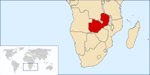
Geography of Zambia
  | |
| Continent | Africa |
|---|---|
| Region | Southern Africa |
| Coordinates | 15°S 30°E / 15°S 30°ECoordinates: 15°S 30°E / 15°S 30°E |
| Area | Ranked 39th |
| • Total | 752,618 km2 (290,587 sq mi) |
| Coastline | 0 km (0 mi) |
| Borders |
5,664 km (Angola 1110 km, DROC 1930 km, Malawi 837 km, Mozambique 419 km, Namibia 233 km, Tanzania 338 km, Zimbabwe 797 km, Botswana <1 km) |
| Highest point |
Mafinga Central, Mafinga Hills 2,339 m |
| Lowest point | Zambezi River, 329 m |
| Longest river |
Zambezi River 2,650 km |

Zambia is a landlocked country located in Southern Africa, to the east of Angola. It has a total area of 752 618 square kilometres (slightly larger than France), of which 9 220 km² are water.
Political geography
Zambia has a total of 5 664 km of land boundaries, and it borders: Angola for 1 110 km, Democratic Republic of the Congo for 1 930 km, Malawi for 837 km, Mozambique for 419 km, Namibia for 233 km, Tanzania for 338 km, Zimbabwe for 797 km, and Botswana, less than 1 km (0.62 mi).
Physical geography
Climate
Zambia has a tropical climate, modified by the altitude of the country. There is a rainy season that runs from October/November to March/April and September.
Terrain
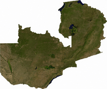
The terrain of Zambia is mostly high plateau, with some hills and mountains. The lowest point is the Zambezi river, at 329 m (1,079 ft) above sea level, with the highest being Mafinga Central in the Mafinga Hills, at 2,339 m (7,674 ft) above sea level.

Zambia a landlocked country bordered along Zimbabwe in the south divided by Victoria Falls, Congo DR in the north, Tanzania on the northeast, Malawi on the east and Mozambique on the southeast. The general topography of the country is characterized by uplifted plantation surfaces. The general elevation of the nation as a whole is tended towards West to East from the Kalahari Basin. The level of land falls from the upper Congo towards the Zambezi depression in the South forming a plateau.[1]
Zambia lies in the watershed between DR Congo and Zambezi river systems. Leaving two provinces, all other provinces lie in the country frontier formed between the continental divide separating the Atlantic Ocean and the Indian Ocean, which traverses from DR Congo to the south of Tanzania. There are three major seasons: a cool dry season from April to August, a hot dry season from August to November and a warm wet season from November to April. The maximum heat is experienced during November, while the maximum rainfall is received during December. The annual rainfall is more than 700 mm (28 in) in the Southern parts, while is more than 1,100 mm (43 in) in the northern parts. Lake Kariba is the manmade lake in Africa and the second largest manmade lake in the world and it stretches along the Southern border of the province.[2]
Ecoregions
Nine ecoregions in four biomes are represented in Zambia, the most widespread being Miombo, Mopane and Baikiaea woodland savanna, with grasslands (mainly flooded grassland) and evergreen forest also present.
Land use
The following table describes the land use in Zambia, as of 2011.
| Use | Percentage of Area |
|---|---|
| arable land | 4.52 |
| permanent crops | 0.05 |
| other | 95.44 |
As of 2005, 1559 km² of land in Zambia is irrigated.
Environment
Current issues for the environment in the country include: air pollution and resulting acid rain in the mineral extraction and refining region; chemical runoff into watersheds; poaching, which seriously threatens: rhinoceros, elephant, antelope, and large cat populations; deforestation; soil erosion; desertification and lack of adequate water treatment, which presents human health risks.
Zambia is party to the following international agreements: Biodiversity, Climate Change, Desertification, Endangered Species, Hazardous Wastes, Law of the Sea, Nuclear Test Ban, Ozone Layer Protection and Wetlands. Zambia has signed, but not ratified, the Kyoto Protocol
Extreme points
This is a list of the extreme points of Zambia, the points that are farther north, south, east or west than any other location.
- Northernmost point - Cape Pungu, Northern province
- Easternmost point - Kongula Peak, Northern province
- Southernmost point - unnamed location on the border with Zimbabwe in the Zambezi river, Southern province
- Westernmost point - the western section of the border with Angola*
* Note: Zambia does not have a westernmost point as the border here is formed by the line of longitude 22° E
References
- ↑ "Geography of Zambia". Zambia Tourism Board. 2011. Retrieved 19 October 2016.
- ↑ Williams, Geoffery J. (2003). "Physical and social geography of Zambia". Africa South of the Sahara 2004. Psychology Press. p. 1995. ISBN 9781857431834.