Geography of the Democratic Republic of the Congo
The Democratic Republic of the Congo is by the Congo River Basin, which covers an area of almost 1,000,000 square kilometres (390,000 sq mi). The country's only outlet to the Atlantic Ocean is a narrow strip of land on the north bank of the Congo River.
The vast, low-lying central area is a plateau-shaped basin sloping toward the west, covered by tropical rainforest and criss-crossed by rivers, a large area of this has been categorized by the World Wildlife Fund as the Central Congolian lowland forests ecoregion. The forest center is surrounded by mountainous terraces in the west, plateaus merging into savannahs in the south and southwest.
Dense grasslands extend beyond the Congo River in the north. High mountains of the Ruwenzori Range (some above 5,000 m or 16,000 ft) are found on the eastern borders with Rwanda and Uganda (see Albertine Rift montane forests for a description of this area).
Climate
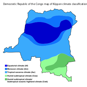
The Democratic Republic of the Congo lies on the Equator, with one-third of the country to the north and two-thirds to the south. The climate is hot and humid in the river basin and cool and dry in the southern highlands, with a cold, alpine climate in the Rwenzori Mountains.
South of the Equator, the rainy season lasts from October to May and north of the Equator, from April to November. Along the Equator, rainfall is fairly regular throughout the year. During the wet season, thunderstorms often are violent but seldom last more than a few hours. The average rainfall for the entire country is about 1,070 mm (42 in).
Data
Location of Congo: Central Africa, northeast of Angola
Geographic coordinates: 0°00′N 25°00′E / 0.000°N 25.000°E
Map references: Africa
Area:
total:
2,344,858 km2
land:
2,267,048 km2
water:
77,810 km2
Area - comparative: slightly less than one-fourth the size of the US
Land boundaries:
total:
10,481 km
border countries:
Angola 2,646 km, Burundi 236 km, Central African Republic 1,747 km, Republic of the Congo 1,229 km, Rwanda 221 km, South Sudan 714 km, Tanzania 479 km, Uganda 877 km, Zambia 2,332 km
Coastline: 37 km (23 mi).
Maritime claims:
territorial sea:
12 nmi (22 km)
exclusive economic zone:
boundaries with neighbors
Climate: tropical; hot and humid in equatorial river basin; cooler and drier in southern highlands; cooler-cold and wetter in eastern highlands and the Ruwenzori Range; north of Equator - wet season April to October, dry season December to February; south of Equator - wet season November to March, dry season April to October

Terrain: vast central plateau covered by tropical rainforest, surrounded by mountains in the west, plains and savanna in the south/southwest, and grasslands in the north. The high mountains of the Ruwenzori Range on the eastern borders.
Elevation extremes:
lowest point:
Atlantic Ocean 0 m
highest point:
Pic Marguerite on Mont Ngaliema (Mount Stanley) 5,110 m
Natural resources: cobalt, copper, niobium, petroleum, industrial and gem diamonds, gold, silver, zinc, manganese, tin, uranium, coal, hydropower, timber
Land use:
arable land:
3.09%
permanent crops:
0.36%
96.55 (2012 est.)
Irrigated land: 105 km2 (2003)
Total renewable water resources: 1,283 km3 (2011)
Freshwater withdrawal (domestic/industrial/agricultural):
total:
0.68 km3/yr (68%/21%/11%)
per capita:
11.25 m3/yr (2005)
Natural hazards: periodic droughts in south; Congo River floods (seasonal); in the east, in the Albertine Rift, there are active volcanoes
Environment - current issues: Poaching threatens wildlife populations (for example, the painted hunting dog, Lycaon pictus, is now considered extirpated from the Congo[1] due to human overpopulation and poaching); water pollution; deforestation (chiefly due to land conversion to agriculture by indigenous farmers[2]); refugees responsible for significant deforestation, soil erosion, and wildlife poaching; mining of minerals (coltan — a mineral used in creating capacitors, diamonds, and gold) causing environmental damage
Environment - international agreements:
party to:
Biodiversity, Climate Change, Desertification, Endangered Species, Hazardous Wastes, Law of the Sea, Marine Dumping, Nuclear Test Ban, Ozone Layer Protection, Tropical Timber 83, Tropical Timber 94, Wetlands
signed, but not ratified:
Environmental Modification
Geography: D.R. Congo is one of 6 African states that straddles the Equator; it's the largest African state that has the Equator passing through it. Very narrow strip of land that controls the lower Congo River and is the only outlet to South Atlantic Ocean; dense tropical rainforest in central river basin and eastern highlands.
Extreme points
This is a list of the extreme points of the Democratic Republic of the Congo, the points that are farther north, south, east or west than any other location.
- Northernmost point - unnamed location on the border with the Central African Republic in the Bomu river immediately west of the town of Mbaga in CAR, Orientale Province
- Easternmost point - at the point where the northern section of the border with Uganda enters Lake Albert immediately west of Mahagi Port, Oritentale Province
- Southernmost point - unnamed location on the border with Zambia immediately to north-west of the Zambian town of Ndabala, Katanga province
- Westernmost point - the point at which the border with Cabinda enters the Atlantic Ocean, Bas-Congo province
See also
Line Notes
References
- C. Michael Hogan. 2009. Painted Hunting Dog: Lycaon pictus, GlobalTwitcher.com, ed. N. Stromberg
- Anne Welsbacher. 2008. Protecting Earth's Rain Forests, page 36