Geography of Burkina Faso

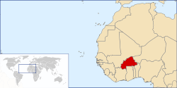


Burkina Faso (formerly Upper Volta) is a landlocked Sahel country that shares borders with six nations. It lies between the Sahara desert and the Gulf of Guinea, south of the loop of the Niger River, mostly between latitudes 9° and 15°N (a small area is north of 15°), and longitudes 6°W and 3°E. The land is green in the south, with forests and fruit trees, and desert in the north. Most of central Burkina Faso lies on a savanna plateau, 198–305 metres (650–1,001 ft) above sea level, with fields, brush, and scattered trees. Burkina Faso's game preserves—the most important of which are Arly, Nazinga, and W National Park—contain lions, elephants, hippopotamus, monkeys, common warthogs, and antelopes. Previously the endangered painted hunting dog, Lycaon pictus occurred in Burkina Faso, but, although the last sightings were made in Arli National Park,[1] the species is considered extirpated from Burkina Faso. Tourism is not well developed.
Area
Burkina Faso has a total area of 274,200 km2, of which 273,800 km2 is land and 400 km2 water. Comparatively, it is slightly larger than New Zealand and Colorado. Its borders total 3,611 km: Benin 386 km, Ivory Coast 545 km, Ghana 602 km, Mali 1,325 km, Niger 622 km, and Togo 131 km. It has no coastline or maritime claims.
Extreme points
This is a list of the extreme points of Burkina Faso, the points that are farther north, south, east or west than any other location.
- Northernmost point – unnamed location on the border with Mali, Sahel Region
- Easternmost point – unnamed location on the border with Benin immediately south of the Burkina Faso-Benin-Niger tripoint, Est Region
- Southernmost point – unnamed location on the border with Ivory Coast immediately south of the village of Kpuere, Sud-Ouest Region
- Westernmost point - the tripoint with Mali and Ivory Coast, Cascades Region
Administrative divisions
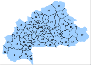

The country is divided into 13 administrative regions. These regions encompass 45 provinces and 351 departments.
Climate
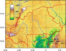
Burkina Faso has a primarily tropical climate with two very distinct seasons. In the rainy season, the country receives between 600 and 900 millimetres (23.6 and 35.4 in) of rainfall; in the dry season, the harmattan – a hot dry wind from the Sahara – blows. The rainy season lasts approximately four months, May/June to September, and is shorter in the north of the country. Three climatic zones can be defined: the Sahel, the Sudan-Sahel, and the Sudan-Guinea. The Sahel in the north typically receives less than 600 millimeters (24 inches) [13] of rainfall per year and has high temperatures, 5–47 degrees Celsius (41–117 degrees Fahrenheit).
A relatively dry tropical savanna, the Sahel extends beyond the borders of Burkina Faso, from the Horn of Africa to the Atlantic Ocean, and borders the Sahara to its north and the fertile region of the Sudan to the South. Situated between 11°3' and 13°5' north latitude, the Sudan-Sahel region is a transitional zone with regards to rainfall and temperature. Further to the south, the Sudan-Guinea zone receives more than 900 millimeters (35 inches)[13] of rain each year and has cooler average temperatures.
Terrain
It is made up of two major types of countryside. The larger part of the country is covered by a peneplain, which forms a gently undulating landscape with, in some areas, a few isolated hills, the last vestiges of a Precambrian massif. The southwest of the country, on the other hand, forms a sandstone massif, where the highest peak, Ténakourou, is found at an elevation of 749 metres (2,457 feet). The massif is bordered by sheer cliffs up to 150 meters (490 feet) high. The average altitude of Burkina Faso is 400 meters (1,300 feet) and the difference between the highest and lowest terrain is no greater than 600 metres (2,000 feet). Burkina Faso is therefore a relatively flat country. Its elevation extremes are a lowest point at the Mouhoun (Black Volta) River (200 m) and highest point at Tena Kourou (749 m).
Hydrography
The country owes its former name of Upper Volta to three rivers which cross it: the Black Volta (or Mouhoun), the White Volta (Nakambé) and the Red Volta (Nazinon). The Black Volta is one of the country's only two rivers which flow year-round, the other being the Komoé, which flows to the southwest. The basin of the Niger River also drains 27% of the country's surface.
The Niger's tributaries – the Béli, the Gorouol, the Goudébo and the Dargol – are seasonal streams and flow for only four to six months a year. They still, however, can cause large floods. The country also contains numerous lakes – the principal ones are Tingrela, Bam and Dem. The country contains large ponds, as well, such as Oursi, Béli, Yomboli and Markoye. Water shortages are often a problem, especially in the north of the country.
Resources and environment
Burkina Faso's natural resources include manganese, limestone, marble, phosphates, pumice, salt and small deposits of gold. 21.93% of its land is arable, and 0.26% has permanent crops as of 2012. As of 2003, 250 km2 were irrigated. Its total renewable water resources as of 2011 were 12.5 m3, with a total freshwater withdrawal of 0.72 km3/yr (46% domestic, 3% industrial, 51% agricultural; this amounts to a per-capita withdrawal of 54.99 m3/yr.
Burkina Faso's fauna and flora are protected in two national parks and several reserves: see List of national parks in Africa, Nature reserves of Burkina Faso.
Recurring droughts and floods are a significant natural hazard.[2] Current environmental issues include: recent droughts and desertification severely affecting agricultural activities, population distribution, and the economy; overgrazing; soil degradation; deforestation.
Burkina Faso is party to the following international environmental agreements: Biodiversity, Climate Change, Desertification, Endangered Species, Hazardous Wastes, Marine Life Conservation, Marine Life Conservation, Ozone Layer Protection, Wetlands. It has signed, but not ratified, the Law of the Sea and the Nuclear Test Ban.
See also
Line note references
![]() This article incorporates public domain material from the CIA World Factbook website https://www.cia.gov/library/publications/the-world-factbook/index.html.
This article incorporates public domain material from the CIA World Factbook website https://www.cia.gov/library/publications/the-world-factbook/index.html.
- ↑ C. Michael Hogan. 2009. Painted Hunting Dog: Lycaon pictus, GlobalTwitcher.com, ed. N. Stromberg Archived December 9, 2010, at the Wayback Machine.
- ↑ Heavy floods caused loss of life and widespread damage in 2007 and 2009. See also 2007 African floods and 2009 West Africa floods.
External links
- Soil Maps of Burkina Faso European Digital Archive on the Soil Maps of the world
Burkina Faso articles | |||||||
|---|---|---|---|---|---|---|---|
| History |  | ||||||
| Geography | |||||||
| Politics | |||||||
| Economy | |||||||
| Culture |
| ||||||
| |||||||