Geography of Senegal

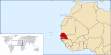
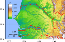
Senegal is a coastal West African nation located 14 degrees north of the Equator and 14 degrees west of the Prime Meridian. The country's total area is 196 190 km² of which 192 000 km² is land and 4 190 km² is water.
Physical features
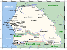
Senegal is bordered to the west by the North Atlantic Ocean. On land, the nation's longest border is with Mauritania to the north, an 813 km border along the Senegal River. To the east is the 419 km border with Mali. In the southeast is Guinea (330 km border) and to the southsouthwest is Guinea-Bissau (338 km), both borders running along the Casamance River. Senegal is one of only a handful of countries to have a near-enclave within its borders—the small nation of the Gambia in the interior, which has a 740 km border with Senegal.
The Gambia penetrates more than 320 km into Senegal, from the Atlantic coast to the center of Senegal along the Gambia River, which bisects Senegal's territory. In total, Senegal has 2 640 km of land borders, and 531 km of coastline and shoreline. Senegal makes maritime claims of a 24 nmi (44.4 km; 27.6 mi) contiguous zone, a 12 nmi (22.2 km; 13.8 mi) territorial sea, and a 370 km (200 nmi; 230 mi) exclusive economic zone. It also claims a 200 nmi (370.4 km; 230.2 mi) continental shelf, or to the edge of the continental margin.
The lowest point in Senegal is the Atlantic Ocean, at sea level. The highest point is an unnamed feature near Nepen Diakha in the Fouta Djallon foothills at 581 m (1,906 ft)).
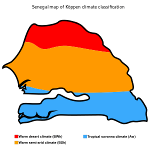
Climate
Tropical; hot, humid; rainy season (May to November) has strong southeast winds; dry season (December to April) dominated by hot, dry, harmattan wind.[1] Well-defined dry and humid seasons result from northeast winter winds and southwest summer winds. Dakar's annual rainfall of about 600 mm (24 in) occurs between June and October when maximum temperatures average 30 °C (86.0 °F) and minimums 24.2 °C (75.6 °F); December to February maximum temperatures average 25.7 °C (78.3 °F) and minimums 18 °C (64.4 °F).[2]
Interior temperatures are higher than along the coast (for example, average daily temperatures in Kaolack and Tambacounda for May are 30 °C (86.0 °F) and 32.7 °C (90.9 °F) respectively, compared to Dakar's 23.2 °C (73.8 °F) ),[3] and rainfall increases substantially farther south, exceeding 1,500 mm (59.1 in) annually in some areas. Extremes in annual precipitation range from 250mm (10 inches) in the extreme north, to 1800mm (71 inches) in extreme southern coastal areas. In the far interior of the country, in the region of Tambacounda, particularly on the border of Mali, temperatures can reach as high as 54 °C (129.2 °F).
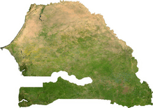
Ecology
Senegal has a number of vegetation zones: sahel, Sahel-Soudan, Sudan_(region), Soudan-Guinea, tropical rainforest, and Guinean mangroves.[4] Most of the southern Casamance arm of the country has been classified by the World Wildlife Fund as part of the Guinean forest-savanna mosaic ecoregion.
Finally, it's worth looking out these 2 last maps, although they include "other zones" as well.
CIA World Factbook
Terrain: generally low, rolling, plains rising to foothills in the southeast.
Natural resources: fish, phosphates, iron ore
Land use:
arable land:
19.57%
permanent crops:
0.28%
other:
80.15% (2011)
Irrigated land: 1,197 km² (2003)
Total renewable water resources: 38.8 km3
Natural hazards: lowlands seasonally flooded; periodic droughts
Environment - current issues: wildlife populations threatened by poaching; deforestation; overgrazing; soil erosion; desertification; overfishing
Senegal is a party to several environmental treaties:
- Comprehensive Test Ban Treaty
- Convention on Biological Diversity
- Convention on Fishing and Conservation of Living Resources of the High Seas
- Convention on the International Trade in Endangered Species of Wild Flora and Fauna
- International Convention for the Regulation of Whaling
- Montreal Protocol
- United Nations Framework Convention on Climate Change
- United Nations Convention to Combat Desertification
- United Nations Convention on the Law of the Sea
- Ramsar Convention
- 1978 Convention on Ship Pollution
Senegal has signed, but not ratified the Convention on Marine Dumping.
Extreme points
This is a list of the extreme points of Senegal, the points that are farther north, south, east or west than any other location.
- Northernmost point – unnamed location on the border with Mauritania in the Senegal river immediately north-west of the town of Podor, Saint-Louis Region
- Easternmost point – unnamed location on the border with Mali near the confluence of the Balin-Ko river and the Falémé River, Kédougou Region
- Southernmost point – unnamed location on the border with Guinea immediately south of the village of Toile, Kédougou Region
- Westernmost point - Pointe des Almadies, Cap Vert peninsula, Dakar Region*
- *Note: this is also the western-most point of the African continent
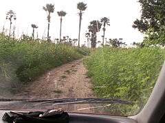
Gallery
-
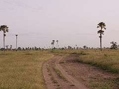
Senegalese savanna.
-
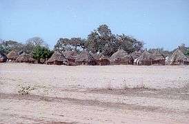
Homes in the countryside.
-
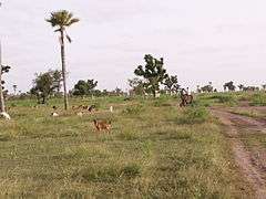
Senegalese savanna with goats
-
Senegalese savanna with high grass
-
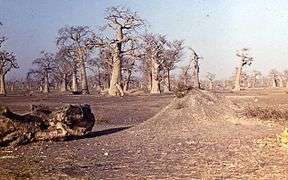
Grove of baobabs
References
- ↑ CIA factbook
- ↑ "Dakar, Senegal Climate, Average Monthly Temperatures, Rainfall, Sunshine Hours, Graphs". ClimaTemps.com. Retrieved 2013-04-22.
- ↑ "Weather rainfall and temperature data". World Climate. Retrieved 2013-04-22.
- ↑ Vegetation zones of Senegal
Senegal articles | |||||||
|---|---|---|---|---|---|---|---|
| History |  | ||||||
| Geography | |||||||
| Politics | |||||||
| Economy | |||||||
| Society |
| ||||||
| |||||||