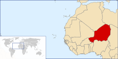
Geography of Niger
  | |
| Continent | Africa |
|---|---|
| Region | Western Africa |
| Coordinates | 16°00′N 08°00′E / 16.000°N 8.000°E |
| Area | Ranked 22nd |
| • Total | 1,266,700 km2 (489,100 sq mi) |
| • Land | 99.98% |
| • Water | 0.02% |
| Coastline | 0 km (0 mi) |
| Borders |
Land boundaries: |
| Irrigated land | 736.6 km² (2005) |
| Total renewable water resources | 33.65 km3 (2011) |
| Highest point | Mont Idoukal-n-Taghès, 2,022 m |
| Lowest point | Niger River, 200 m |
| Climate | Desert to tropical |
| Terrain | Mostly desert plains and sand dunes, hills in the north |
| Natural Resources | Uranium, coal, iron ore, tin, phosphates, gold, molybdenum, gypsum, salt, petroleum |
| Natural Hazards | Recurring droughts |
| Environmental Issues | Overgrazing, soil erosion, deforestation, poaching |
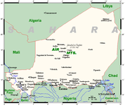
Niger is a landlocked nation in West Africa located along the border between the Sahara and Sub-Saharan regions. Its geographic coordinates are longitude 16°N and latitude 8°E. Its area is 1.267 million square kilometers, of which 1 266 700 km² is land and 300 km² water, making Niger slightly less than twice the size of France.[1]
Brief history
Niger which attained independence from France in 1960 was under military regime till 1991. On public demand Gen. Ali Saibou held multiparty elections in 1993 and soon democracy came in to effect in 1993. However, political unrest was caused by Col. Ibrahim Bare who staged a coup in 1999, but he died in a counter insurgency operations by officers of the military establishment. This was followed by fresh elections for a democratic rule, and Mamadou Tandja assumed power in December 1999. Tandja,who won the elections in 2004 and in 2009, wanted to bring about a constitutional amendment to extend his tenure as president. However, in February 2010, he was removed from the post of the president in a coup engineered by the military and the constitution was annulled. Soon after, in 2011, elections were held and Mahamadou Issoufou got elected as the president and was sworn in April 2011.[1] Niger’s problem with rebellious groups continued during 2007 and 2008. Rebellion was controlled. However, its security problems with its neighbors such as Libya, Nigeria and Mali have been a cause for concern[1]
Geography
Niger, with a land area of 1.267 million km2, is a land locked country which is bounded with a land boundary of 5,834 km by seven countries: Algeria (951 km), Benin (277 km), Burkina Faso (622 km), Chad (1,196 km), Libya (342 km), Mali (838 km, and Nigeria (1,608) km.[1]
Regions
Niger is divided into 7 Regions (French: régions; singular – région). Each department's capital is the same as its name.
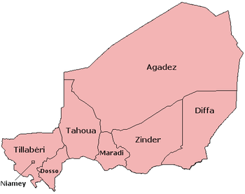

| Region | Area (km2) [2] |
Population (2012 census) |
|---|---|---|
| Agadez | 667,799 | 487,620 |
| Diffa | 156,906 | 593,821 |
| Dosso | 33,844 | 2,037,713 |
| Maradi | 41,796 | 3,402,094 |
| Niamey | 402 | 1,026,848 |
| Tahoua | 113,371 | 3,328,365 |
| Tillabéri | 97,251 | 2,722,842 |
| Zinder | 155,778 | 3,539,764 |
- The national capital, Niamey, comprises a capital district.
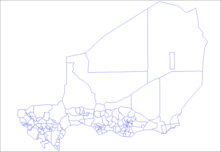
Departments
The Regions of Niger are subdivided into 63 Departments.
Communes
The 63 Departments are broken down into Communes. As of 2006 there were 265 communes, including communes urbaines (Urban Communes: centred in or as subdivisions of cities of over 10000), communes rurales (Rural Communes) centred in cities of under 10,000 and/or sparsely populated areas, and a variety of traditional (clan or tribal) bodies amongst semi-nomadic populations.
Cities
 Niger's cities, main towns and other centres
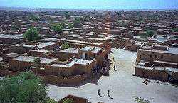 Agadez is the largest city in central Niger, with a population of 88,569 (2005 census)
Roadways
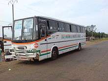
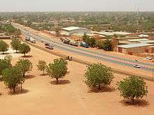 Truck and car traffic along Boulevard Mali Bero, Niamey, Niger
Physical geography
Agricultural geography
Some of the land in Niger is used as arable land (660 km² of land in Niger is irrigated) and as pasture. There are some forests and woodland. The table below describes land use in Niger, as of 2011.
| Use | Percentage of Area |
|---|---|
| arable land | 11.79 [1] |
| permanent crops | 0.05 [1] |
| other | 88.16 [1] |
Climate
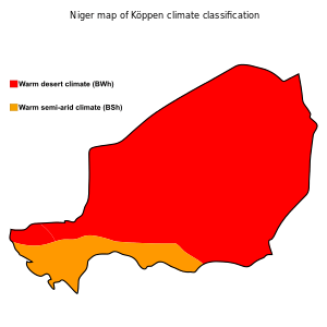
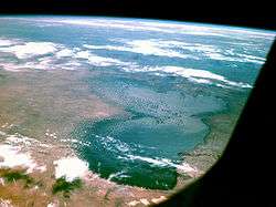
Niger's climate is largely hot and dry, with most of the country in a desert region. The terrain there is predominantly desert plains and sand dunes. There are also large plains in the south and hills in the north. In the extreme south, there is a tropical climate near the edges of the Niger River Basin. Lake Chad at the southeast corner of the country is shared between Niger, Nigeria, Chad, and Cameroon.
Current issues
Current environmental issues in Niger include: overgrazing, soil erosion, deforestation, desertification, recurring droughts, and endangered wildlife populations (such as the African elephant, Northwest African cheetah, West African giraffe, and Addax), which are threatened because of poaching and habitat destruction.[3]
Natural hazards
Recurring droughts are a hazard in Niger.[4] The 2012 Sahel drought, along with failed crops, insect plagues, high food prices and conflicts is currently affecting Niger causing a hunger crisis.[5] Many families in Niger, still recovering from the 2010 Sahel famine, are being affected by the 2012 Sahel drought.[6]
The 2005–06 Niger food crisis created a severe, but localized food security crisis in the regions of northern Maradi, Tahoua, Tillabéri, and Zinder of Niger from 2005 to 2006. It was caused by an early end to the 2004 rains, desert locust damage to some pasture lands, high food prices, and chronic poverty.
Extreme points
- Northernmost point: Tripoint with Algeria and Libya, Agadez Region: 23°31'N.[7]
- Southernmost point: Benin/Niger/Nigeria tripoint, Dosso Region: 11°42'N
- Easternmost point: border with Chad, Agadez Region: 16°00'E
- Westernmost point: border with Mali and Burkina Faso, Tillabéri Region: 0°07'E
- Highest point: Mont Idoukal-n-Taghès, Aïr Massif, Agadez Region:2,022 m (6,634 ft)[1]
- Lowest point: Niger River at Nigeria border, Dosso Region: 200 m (656 ft)[1]
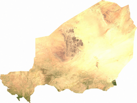
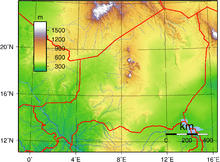 Topography of Niger
International agreements
Niger is a party to the following agreements:
Niger has signed, but not ratified the Kyoto Protocol and Law of the Sea.[8][9]
National parks and reserves
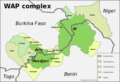
- Main articles: List of national parks of Niger and Wildlife of Niger § National Parks and reserves
Niger's protected areas comprise about 7.7 percent of the total land area.[10] Six of the reserves are fully categorized under the International Union for Conservation of Nature (IUCN).
Natural resources
Niger possesses the following natural resources:
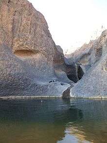
Waterways
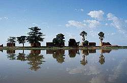 Mud houses on the center island at Lake Debo, a wide section of the Niger River
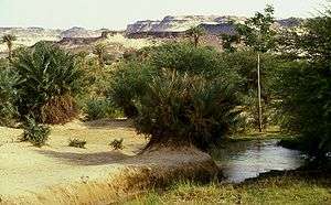
 The Timia oasis
Wildlife
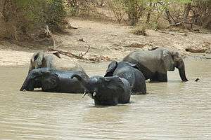 African bush elephants photographed in the Niger section of the W National Park complex of protected areas.
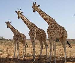 West African giraffes in Kouré, Niger.
Political geography
Surrounded by seven other countries, Niger has a total of 5,834 km of borders. The longest border is with Nigeria to the south, at 1,608 km. This is followed by Chad to the east (1,196 km), Algeria to the north-northwest (951 km), and Mali to the west (838 km). Niger also has short borders in its far southwest frontier (Burkina Faso at 622 km and Benin at 277 km) and to the north-northeast (Libya at 342 km).[1]
See also
References
- 1 2 3 4 5 6 7 8 9 10 11 "The World Factbook". CIA.gov. Retrieved 20 April 2015.
- ↑ Niger at GeoHive
- ↑ "Niger: African Wildlife Foundation". AfricanWildlifeFoundation.com. Retrieved 20 April 2015.
- ↑ "Learning the Lessons?" (PDF). Oxfam. 16 April 2013. Retrieved 20 April 2015.
- ↑ Fominyen, George (24 May 2012). "Coming weeks critical to tackle Sahel hunger ? U.N. humanitarian chief". trust.cm. Retrieved 27 April 2013.
- ↑ "West African food crisis 2012". trust.com. 22 January 2013. Retrieved 27 April 2013.
- ↑ "Libya – Niger Boundary" (PDF). International Boundary Study. Office of the Geographer - Bureau of Intelligence and Research. 4 May 1961. Retrieved 20 April 2015.
- ↑ "UNTC". United Nations.
- ↑ "UNTC". United Nations.
- ↑ "Niger: Country Pasture/Forage Resource Profiles". FAO Organization. Retrieved 18 March 2013.
- ↑ "France backs Niger in talks with Areva over uranium mining". The Guardian. 6 February 2014. Retrieved 9 February 2014.
- 1 2 3 "THE MINERAL INDUSTRY OF OTHER COUNTRIES OF AFRICA" (PDF). United States Geological Survey. 1994. p. 21. Retrieved 9 February 2014.
- ↑ "NIGER: Coal the new weapon to stop desert advance". Integrated Regional Information Networks. 1 July 2004. Retrieved 9 February 2014.
- ↑ "CROSS-BORDER DIARIES" (PDF). Organisation for Economic Co-operation and Development. June 2007. p. 52. Retrieved 9 February 2014.
- ↑ Els, Frik (19 June 2013). "Semafo up 4% after tracing new trend over 10 kilometers in Niger". Mining.com. Retrieved 9 February 2014.
- ↑ Issa, Ousseini (15 May 2013). "Protecting Niger's Desert Salt Pans". Inter Press Service. Retrieved 9 February 2014.
- ↑ "As refinery opens, Niger joins club of oil producers". Agence France-Presse. 28 November 2011. Retrieved 9 February 2014.
Further reading
- L. Herrmann, K. Stahr and K. Vennemann. Atlas of Natural and Agronomic Resources of Niger and Benin, "Deutsche Forschungsgemeinschaft" (German Research Foundation), the University of Hohenheim. (No date). Retrieved 2008-02-22.
Capital: Niamey in Niamey Capital District | |
| Agadez Region | |
| Diffa Region | |
| Dosso Region | |
| Maradi Region | |
| Tahoua Region | |
| Tillabéri Region | |
| Zinder Region | |