Forbes Road
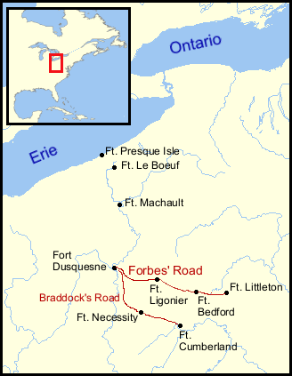
The Forbes Road was a historic military roadway in what was then British America, that was constructed in 1758 from Carlisle, Pennsylvania, to the French Fort Duquesne at the junction of the Allegheny and Monongahela rivers in what is now downtown Pittsburgh, via Fort Littleton, Fort Bedford and Fort Ligonier. The road, 300 miles long,[1] was named for Brigadier General John Forbes, the commander of the 1758 British expedition that built the road during the French and Indian War in Pennsylvania. The Forbes Road and Braddock's Road were the two main land routes that the British cut west through the Appalachian wilderness during the war, despite the need to travel over and past a succession of steep north-south ridges that interfered with east-west travel.
History
Construction
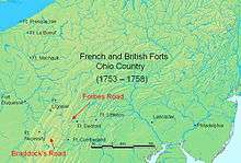
Like General Edward Braddock, General Forbes faced great difficulty when transporting his army and artillery to Fort Duquesne through a wilderness previously traveled only by indigenous tribes and fur traders. Benefiting from the experience of Braddock's ill-fated 1755 military expedition, Forbes constructed forts at regular intervals along the new road and established supply lines between the forts. Forbes avoided Braddock's Road and encounters with the enemy before the expedition reached Fort Duquesne.
Forbes' army captured Fort Duquesne from the French army on November 25, 1758. Forbes then built a much larger fort on the site, naming it Fort Pitt. Construction of the Forbes Road made transportation of supplies, soldiers, messages, and trade easier between the eastern farms and cities and western portions of Pennsylvania, and provided an important route west for settlers. The Forbes Road provided a more direct route to Ohio Country through Pennsylvania compared to Braddock's Road, which was constructed west from Cumberland, Maryland, then north into Pennsylvania .
Later roads
Later, U.S. Route 22 (US 22) largely followed portions of the Forbes Road from Monroeville through a town now named "Forbes Road" and Hannastown to Latrobe. The Lincoln Highway (US 30) largely followed the Forbes Road between Latrobe and Bedford. Still later, a portion of the Pennsylvania Turnpike (Interstate 76) largely followed a portion of the Forbes Road from Bedford over the Appalachian mountains to Carlisle.[2]
In contrast to the Forbes Road's successors, the National Road, now US 40, largely followed Braddock's Road across the Appalachian Mountains from Cumberland into Pennsylvania.
Markers

Many historical markers indicate locations along the original route where Forbes traveled with his army. In Westmoreland County, a Forbes Road marker is located along US 22, 1.2 miles (1.9 km) east of Murrysville. In Cumberland County, there are markers along US 11 southwest of Carlisle and one mile northeast of Shippensburg. In Fulton County, there is a marker along US 522, 0.2 miles (0.32 km) southwest of Burnt Cabins. Forbes Road markers have also been erected in Allegheny, Bedford, and Somerset counties.[3]
See also
- Braddock Road
- Lincoln Highway
- French and Indian War
- Great Britain in the Seven Years War
- Battle of Fort Duquesne
References
- ↑ Fisher, Laura (2008). Pennsylvania's Forbes Trail. Taylor Trade Publishing. p. 10. ISBN 1-58979-388-9.
- ↑ Locations of Forbes Road markers
- ↑ Forbes Road markers
External links
| Wikimedia Commons has media related to Forbes Road. |
- Forbes Road
- Locations of Forbes Road markers (click on link at top to get map of markers)
- History of Westmoreland County, page 1
- Early History of Westmoreland County
Pennsylvania during the French and Indian War | ||
|---|---|---|
| 1754 | 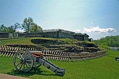 | |
| 1755 | ||
| 1756 | ||
| 1758 | ||
| 1763 | ||
| Frontier Forts | ||
| Counties |  Map of the Pittsburgh Tri-State with green counties in the metropolitan area and yellow counties in the combined area. | |
|---|---|---|
| Major cities | ||
| Cities and towns 15k-50k (in 2010) | ||
| Airports | ||
| Topics | ||
| ||