East Brenham
|
East Brenham Historic District | |
 | |
  | |
| Location | Roughly bounded by Crockett, Embrey, E. Academy, Ross, E. Main, Market, Sycamore, Cottonwood, Botts, McIntyre, and Alma in Brenham, Texas |
|---|---|
| Coordinates | 30°10′15″N 96°23′37″W / 30.17083°N 96.39361°WCoordinates: 30°10′15″N 96°23′37″W / 30.17083°N 96.39361°W |
| Area | 58 acres (23 ha) |
| Architectural style | Late 19th And Early 20th Century American Movements, Late 19th And 20th Century Revivals |
| MPS | Brenham MPS |
| NRHP Reference # | 90000445[1] |
| Added to NRHP | March 29, 1990 |
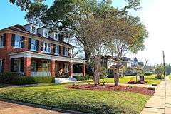
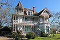
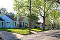
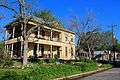
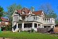
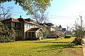
East Brenham Historic District is residential area located northeast of downtown Brenham, Texas.
Comprising about nine city blocks, the district contains 79 contributing resources, primarily residential with a some commercial buildings and a church. The oldest building is an 1881 house, most of the buildings date from about 1875 to 1940.[2]
The district was added to the National Register of Historic Places on March 29, 1990 as an example of a cohesive residential neighborhood from the late 19th to early 20th centuries.[2]
Photo gallery

References
- ↑ National Park Service (2010-07-09). "National Register Information System". National Register of Historic Places. National Park Service.
- 1 2 "East Brenham". Texas Historical Commission. Retrieved 2015-11-17.


This article is issued from Wikipedia - version of the 11/29/2016. The text is available under the Creative Commons Attribution/Share Alike but additional terms may apply for the media files.