| [3] |
Name on the Register[4] |
Image |
Date listed[5] |
Location |
City or town |
Description |
|---|
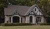
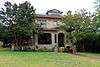
| 1 |
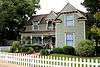
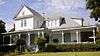
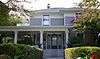
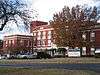
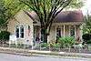
Allen Water Station |
|
000000002009-12-03-0000December 3, 2009
(#09000980) |
North of Exchange parkway on Cottonwood Creek
33°07′02″N 96°39′58″W / 33.11725°N 96.666008°W / 33.11725; -96.666008 (Allen Water Station) |
Allen |
|
| 2 |
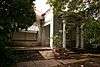
Aston Building |
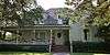
|
000000001983-06-30-0000June 30, 1983
(#83003131) |
113 S. Main St.
33°09′46″N 96°21′34″W / 33.162778°N 96.359444°W / 33.162778; -96.359444 (Aston Building) |
Farmersville |
|
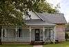
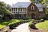
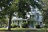
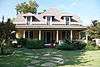
| 3 |
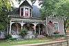
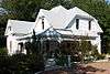
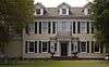
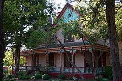
Beverly-Harris House |
|
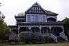
000000001987-10-08-0000October 8, 1987
(#87001661) |
604 Parker
33°11′36″N 96°37′19″W / 33.193333°N 96.621944°W / 33.193333; -96.621944 (Beverly-Harris House) |
McKinney |
|
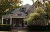
| 4 |
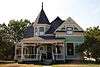
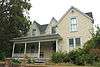
John H. Bingham House |
|
000000001988-06-27-0000June 27, 1988
(#87001662) |
800 S. Chestnut
33°11′24″N 96°36′50″W / 33.19°N 96.613889°W / 33.19; -96.613889 (John H. Bingham House) |
McKinney |
|
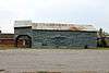
| 5 |
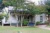
Board-Everett House |
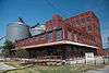
|
000000001987-10-08-0000October 8, 1987
(#87001663) |
507 N. Bradley
33°12′08″N 96°37′24″W / 33.202222°N 96.623333°W / 33.202222; -96.623333 (Board-Everett House) |
McKinney |
|
| 6 |
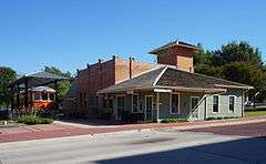
John R. Brown House |
|
000000001987-10-08-0000October 8, 1987
(#87001666) |
509 N. Church
33°12′06″N 96°37′02″W / 33.201667°N 96.617222°W / 33.201667; -96.617222 (John R. Brown House) |
McKinney |
|
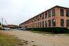
| 7 |
Burrus-Finch House |
|
000000001988-06-27-0000June 27, 1988
(#87001671) |
405 N. Waddill
33°12′03″N 96°37′36″W / 33.200833°N 96.626667°W / 33.200833; -96.626667 (Burrus-Finch House) |
McKinney |
|
| 8 |
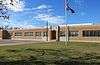
Celina Public School |
|
000000002009-10-14-0000October 14, 2009
(#09000839) |
205 S. Colorado St.
33°19′23″N 96°47′16″W / 33.323136°N 96.787836°W / 33.323136; -96.787836 (Celina Public School) |
Celina |
|
| 9 |
U. P. Clardy House |
|
000000001987-10-08-0000October 8, 1987
(#87001679) |
315 Oak
33°12′00″N 96°37′27″W / 33.2°N 96.624167°W / 33.2; -96.624167 (U. P. Clardy House) |
McKinney |
|
| 10 |
Cline-Bass House |
|
000000001988-06-27-0000June 27, 1988
(#87001681) |
804 Tucker
33°12′10″N 96°37′33″W / 33.202778°N 96.625833°W / 33.202778; -96.625833 (Cline-Bass House) |
McKinney |
|
| 11 |
J. R. Coggins House |
|
000000001987-10-08-0000October 8, 1987
(#87001682) |
805 Howell
33°11′40″N 96°37′18″W / 33.194444°N 96.621667°W / 33.194444; -96.621667 (J. R. Coggins House) |
McKinney |
|
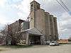
| 12 |
Collin County Mill and Elevator Company |
|
000000001987-10-08-0000October 8, 1987
(#87001685) |
407 E. Louisiana
33°11′51″N 96°36′34″W / 33.1975°N 96.609444°W / 33.1975; -96.609444 (Collin County Mill and Elevator Company) |
McKinney |
|
| 13 |
Crouch-Perkins House |
|
000000001987-10-08-0000October 8, 1987
(#87001691) |
205 N. Church
33°11′53″N 96°36′23″W / 33.198056°N 96.606389°W / 33.198056; -96.606389 (Crouch-Perkins House) |
McKinney |
|
| 14 |
H. L. Davis House |
|
000000001987-10-08-0000October 8, 1987
(#87001695) |
705 N. College
33°12′13″N 96°37′15″W / 33.203611°N 96.620833°W / 33.203611; -96.620833 (H. L. Davis House) |
McKinney |
|
| 15 |
Davis-Hill House |
|
000000001987-10-08-0000October 8, 1987
(#87001697) |
710 N. Church
33°12′19″N 96°36′59″W / 33.205278°N 96.616389°W / 33.205278; -96.616389 (Davis-Hill House) |
McKinney |
|
| 16 |
J. S. Dowell House |
|
000000001987-10-08-0000October 8, 1987
(#87001699) |
608 Parker
33°11′35″N 96°37′20″W / 33.193056°N 96.622222°W / 33.193056; -96.622222 (J. S. Dowell House) |
McKinney |
|
| 17 |
Joe E. Dulaney House |
|
000000001987-10-08-0000October 8, 1987
(#87001704) |
311 S. Chestnut
33°11′41″N 96°36′46″W / 33.194722°N 96.612778°W / 33.194722; -96.612778 (Joe E. Dulaney House) |
McKinney |
|
| 18 |
Joseph Field Dulaney House |
|
000000001987-10-08-0000October 8, 1987
(#87001702) |
315 S. Chestnut
33°11′40″N 96°36′46″W / 33.194444°N 96.612778°W / 33.194444; -96.612778 (Joseph Field Dulaney House) |
McKinney |
|
| 19 |
Estes House |
|
000000001995-11-29-0000November 29, 1995
(#95001365) |
903 N. College St.
33°12′16″N 96°37′15″W / 33.204444°N 96.620833°W / 33.204444; -96.620833 (Estes House) |
McKinney |
|
| 20 |
F. C. Faires House |
|
000000001987-10-08-0000October 8, 1987
(#87001705) |
505 S. Chestnut
33°11′32″N 96°36′47″W / 33.192222°N 96.613056°W / 33.192222; -96.613056 (F. C. Faires House) |
McKinney |
|
| 21 |
Faires-Bell House |
|
000000001987-10-08-0000October 8, 1987
(#87001706) |
S side Chestnut Sq.
33°11′40″N 96°36′45″W / 33.194444°N 96.6125°W / 33.194444; -96.6125 (Faires-Bell House) |
McKinney |
|
| 22 |
Fairview H&TC Railroad Historic District |
Upload image |
000000002010-05-10-0000May 10, 2010
(#10000247) |
About 1/4 mi. W of St HWY 5 on Sloan Creek & the former Houston & Texas Central Railroad tracks
33°08′50″N 96°38′28″W / 33.147222°N 96.641111°W / 33.147222; -96.641111 (Fairview H&TC Railroad Historic District) |
Fairview |
Houston and Texas Central Railway
|
| 23 |
Farmersville Masonic Lodge No. 214, A.F. and A.M. |
|
000000002005-03-30-0000March 30, 2005
(#05000245) |
101 S. Main St.
33°09′55″N 96°21′35″W / 33.165278°N 96.359722°W / 33.165278; -96.359722 (Farmersville Masonic Lodge No. 214, A.F. and A.M.) |
Farmersville |
|
| 24 |
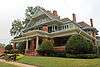
John H. Ferguson House |
|
000000001987-10-08-0000October 8, 1987
(#87001707) |
607 N. Church
33°12′10″N 96°37′02″W / 33.202778°N 96.617222°W / 33.202778; -96.617222 (John H. Ferguson House) |
McKinney |
|
| 25 |
Foote-Crouch House |
|
000000001988-06-27-0000June 27, 1988
(#87001708) |
401 N. Benge
33°11′40″N 96°37′03″W / 33.194444°N 96.6175°W / 33.194444; -96.6175 (Foote-Crouch House) |
McKinney |
|
| 26 |
S. H. Fox House |
|
000000001987-10-08-0000October 8, 1987
(#87001709) |
808 Tucker
33°12′10″N 96°37′32″W / 33.202778°N 96.625556°W / 33.202778; -96.625556 (S. H. Fox House) |
McKinney |
|
| 27 |
Jim B. Goodner House |
|
000000001987-10-08-0000October 8, 1987
(#87001688) |
302 S. Tennessee
33°11′42″N 96°36′54″W / 33.195°N 96.615°W / 33.195; -96.615 (Jim B. Goodner House) |
McKinney |
|
| 28 |
Gough-Hughston House |
|
000000001988-06-27-0000June 27, 1988
(#87001710) |
1206 W. Louisiana
33°11′50″N 96°37′36″W / 33.197222°N 96.626667°W / 33.197222; -96.626667 (Gough-Hughston House) |
McKinney |
|
| 29 |
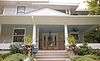
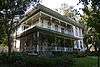
Heard-Craig House |
|
000000001987-10-08-0000October 8, 1987
(#87001711) |
205 W. Hunt
33°11′55″N 96°37′00″W / 33.198611°N 96.616667°W / 33.198611; -96.616667 (Heard-Craig House) |
McKinney |
|
| 30 |
Ben Hill House |
|
000000001987-10-08-0000October 8, 1987
(#87001712) |
509 Tucker
33°12′08″N 96°37′42″W / 33.202222°N 96.628333°W / 33.202222; -96.628333 (Ben Hill House) |
McKinney |
|
| 31 |
John B. Hill House |
|
000000001987-10-08-0000October 8, 1987
(#87001713) |
605 N. College
33°12′10″N 96°37′15″W / 33.202778°N 96.620833°W / 33.202778; -96.620833 (John B. Hill House) |
McKinney |
|
| 32 |
Moran Hill House |
|
000000001987-10-08-0000October 8, 1987
(#87001714) |
203 N. Waddill
33°11′53″N 96°37′36″W / 33.198056°N 96.626667°W / 33.198056; -96.626667 (Moran Hill House) |
McKinney |
|
| 33 |
W. R. Hill House |
|
000000001987-10-08-0000October 8, 1987
(#87001715) |
601 N. College
33°12′09″N 96°37′16″W / 33.2025°N 96.621111°W / 33.2025; -96.621111 (W. R. Hill House) |
McKinney |
|
| 34 |
Hill-Webb Grain Elevator |
|
000000001987-10-08-0000October 8, 1987
(#87001716) |
400 E. Louisiana
33°11′47″N 96°36′34″W / 33.196389°N 96.609444°W / 33.196389; -96.609444 (Hill-Webb Grain Elevator) |
McKinney |
|
| 35 |
House at 1303 W. Louisiana |
|
000000001987-10-08-0000October 8, 1987
(#87001717) |
1303 W. Louisiana
33°11′48″N 96°37′39″W / 33.196667°N 96.6275°W / 33.196667; -96.6275 (House at 1303 W. Louisiana) |
McKinney |
|
| 36 |
House at 201 N. Graves |
|
000000001987-10-08-0000October 8, 1987
(#87001718) |
201 N. Graves
33°11′55″N 96°37′47″W / 33.198611°N 96.629722°W / 33.198611; -96.629722 (House at 201 N. Graves) |
McKinney |
|
| 37 |
House at 301 E. Lamar |
Upload image |
000000001987-10-08-0000October 8, 1987
(#87001719) |
301 E. Lamar
33°12′02″N 96°37′03″W / 33.200556°N 96.6175°W / 33.200556; -96.6175 (House at 301 E. Lamar) |
McKinney |
|
| 38 |
House at 610 Tucker |
Upload image |
000000001987-10-08-0000October 8, 1987
(#87001720) |
610 Tucker
33°12′10″N 96°37′38″W / 33.202778°N 96.627222°W / 33.202778; -96.627222 (House at 610 Tucker) |
McKinney |
|
| 39 |
House at 704 Parker |
|
000000001987-10-08-0000October 8, 1987
(#87001721) |
704 Parker
33°11′33″N 96°37′20″W / 33.1925°N 96.622222°W / 33.1925; -96.622222 (House at 704 Parker) |
McKinney |
|
| 40 |
Houses at 406 and 408 Heard |
|
000000001987-10-08-0000October 8, 1987
(#87001722) |
406 & 408 Heard
33°12′16″N 96°37′05″W / 33.204444°N 96.618056°W / 33.204444; -96.618056 (Houses at 406 and 408 Heard) |
McKinney |
|
| 41 |
John Johnson House |
|
000000001987-10-08-0000October 8, 1987
(#87001723) |
302 Anthony
33°11′37″N 96°36′46″W / 33.193611°N 96.612778°W / 33.193611; -96.612778 (John Johnson House) |
McKinney |
|
| 42 |
Thomas Johnson House |
|
000000001987-10-08-0000October 8, 1987
(#87001724) |
312 S. Tennessee
33°11′40″N 96°36′54″W / 33.194444°N 96.615°W / 33.194444; -96.615 (Thomas Johnson House) |
McKinney |
|
| 43 |
Mrs. J. C. King House |
|
000000001988-10-13-0000October 13, 1988
(#87001737) |
405 W. Louisiana
33°11′47″N 96°36′28″W / 33.196389°N 96.607778°W / 33.196389; -96.607778 (Mrs. J. C. King House) |
McKinney |
|
| 44 |
E. W. Kirkpatrick House and Barn |
|
000000001987-10-08-0000October 8, 1987
(#87001738) |
903 Parker
33°11′21″N 96°37′20″W / 33.189167°N 96.622222°W / 33.189167; -96.622222 (E. W. Kirkpatrick House and Barn) |
McKinney |
|
| 45 |
McKinney Commercial Historic District |
|
000000001983-01-10-0000January 10, 1983
(#83003132) |
Roughly bounded by Herndon, Wood, Cloyd, Davis, Louisiana, MacDonald, and Virginia Sts.
33°11′51″N 96°36′51″W / 33.1975°N 96.614167°W / 33.1975; -96.614167 (McKinney Commercial Historic District) |
McKinney |
|
| 46 |
McKinney Cotton Compress Plant |
|
000000001988-06-27-0000June 27, 1988
(#87001739) |
300 blk. Throckmorton
33°12′01″N 96°36′22″W / 33.200278°N 96.606111°W / 33.200278; -96.606111 (McKinney Cotton Compress Plant) |
McKinney |
|
| 47 |
McKinney Cotton Mill Historic District |
|
000000001987-10-08-0000October 8, 1987
(#87001740) |
Roughly bounded by Elm, RR tracks, Burrus, Fowler, & Amscott
33°10′59″N 96°36′39″W / 33.183056°N 96.610833°W / 33.183056; -96.610833 (McKinney Cotton Mill Historic District) |
McKinney |
|
| 48 |
Old McKinney Hospital |
|
000000001987-10-08-0000October 8, 1987
(#87001743) |
700-800 S. College
33°11′26″N 96°37′16″W / 33.190556°N 96.621111°W / 33.190556; -96.621111 (Old McKinney Hospital) |
McKinney |
|
| 49 |
McKinney Residential Historic District |
|
000000001987-10-08-0000October 8, 1987
(#87001744) |
Roughly bounded by W. Lamar, N. Benge, W. Louisiana, & N. Oak
33°11′56″N 96°37′15″W / 33.198889°N 96.620833°W / 33.198889; -96.620833 (McKinney Residential Historic District) |
McKinney |
|
| 50 |
Sam Neathery House |
|
000000001988-06-27-0000June 27, 1988
(#87001745) |
215 N. Waddill
33°11′56″N 96°37′36″W / 33.198889°N 96.626667°W / 33.198889; -96.626667 (Sam Neathery House) |
McKinney |
|
| 51 |
J. P. Nenney House |
|
000000001988-06-27-0000June 27, 1988
(#87001746) |
601 N. Church
33°12′07″N 96°37′02″W / 33.201944°N 96.617222°W / 33.201944; -96.617222 (J. P. Nenney House) |
McKinney |
|
| 52 |
R. F. Newsome House |
|
000000001987-10-08-0000October 8, 1987
(#87001747) |
609 Tucker
33°12′08″N 96°37′38″W / 33.202222°N 96.627222°W / 33.202222; -96.627222 (R. F. Newsome House) |
McKinney |
|
| 53 |
Newsome-King House |
|
000000001987-10-08-0000October 8, 1987
(#87001748) |
401 W. Louisiana
33°11′48″N 96°36′27″W / 33.196667°N 96.6075°W / 33.196667; -96.6075 (Newsome-King House) |
McKinney |
|
| 54 |
Plano Station, Texas Electric Railway |
|
000000002005-08-10-0000August 10, 2005
(#05000856) |
901 E 15th St.
33°01′11″N 96°42′06″W / 33.019722°N 96.701667°W / 33.019722; -96.701667 (Plano Station, Texas Electric Railway) |
Plano |
AKA Interurban Railway Museum
|
| 55 |
John C. Rhea House |
|
000000001988-06-27-0000June 27, 1988
(#87001749) |
801 N. College
33°12′14″N 96°37′15″W / 33.203889°N 96.620833°W / 33.203889; -96.620833 (John C. Rhea House) |
McKinney |
|
| 56 |
A. M. Scott House |
|
000000001987-10-08-0000October 8, 1987
(#87001750) |
1109 W. Louisiana
33°11′48″N 96°37′34″W / 33.196667°N 96.626111°W / 33.196667; -96.626111 (A. M. Scott House) |
McKinney |
|
| 57 |
L. A. Scott House |
|
000000001988-06-27-0000June 27, 1988
(#87001751) |
513 W. Louisiana
33°11′48″N 96°37′15″W / 33.196667°N 96.620833°W / 33.196667; -96.620833 (L. A. Scott House) |
McKinney |
|
| 58 |
Sister Grove Creek Site |
Upload image |
000000001977-08-22-0000August 22, 1977
(#77001432) |
Address Restricted
|
Farmersville |
|
| 59 |
W. D. Smith House |
|
000000001987-10-08-0000October 8, 1987
(#87001752) |
703 N. College
33°12′11″N 96°37′15″W / 33.203056°N 96.620833°W / 33.203056; -96.620833 (W. D. Smith House) |
McKinney |
|
| 60 |
J. H. Taylor House |
|
000000001987-10-08-0000October 8, 1987
(#87001753) |
211 N. Waddill
33°11′55″N 96°37′36″W / 33.198611°N 96.626667°W / 33.198611; -96.626667 (J. H. Taylor House) |
McKinney |
|
| 61 |
Thompson House |
|
000000001987-10-08-0000October 8, 1987
(#87001754) |
1207 W. Louisiana
33°11′48″N 96°37′37″W / 33.196667°N 96.626944°W / 33.196667; -96.626944 (Thompson House) |
McKinney |
|
| 62 |
R. L. Waddill House |
|
000000001987-10-08-0000October 8, 1987
(#87001755) |
302 W. Lamar
33°12′02″N 96°36′46″W / 33.200556°N 96.612778°W / 33.200556; -96.612778 (R. L. Waddill House) |
McKinney |
|
| 63 |
Thomas W. Wiley House |
|
000000001987-10-08-0000October 8, 1987
(#87001756) |
105 S. Church
33°11′48″N 96°37′01″W / 33.196667°N 96.616944°W / 33.196667; -96.616944 (Thomas W. Wiley House) |
McKinney |
|
| 64 |
A. G. Wilson House |
|
000000001987-10-08-0000October 8, 1987
(#87001757) |
417 N. Waddill
33°12′05″N 96°37′36″W / 33.201389°N 96.626667°W / 33.201389; -96.626667 (A. G. Wilson House) |
McKinney |
|
| 65 |
Ammie Wilson House |
|
000000001978-12-28-0000December 28, 1978
(#78002906) |
1900 W. 15th St.
33°01′08″N 96°43′52″W / 33.018889°N 96.731111°W / 33.018889; -96.731111 (Ammie Wilson House) |
Plano |
|