National Register of Historic Places listings in Hidalgo County, Texas
List of Registered Historic Places in Hidalgo County, Texas
This is intended to be a complete list of properties and districts listed on the National Register of Historic Places in Hidalgo County, Texas. The locations of National Register properties and districts (at least for all showing latitude and longitude coordinates below) may be seen in a map by clicking on "Map of all coordinates".[1]
- This National Park Service list is complete through NPS recent listings posted December 2, 2016.[2]
| [3] | Name on the Register[4] | Image | Date listed[5] | Location | City or town | Description |
|---|---|---|---|---|---|---|
| 1 | Border Theater | 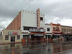 |
(#98001124) |
905 North Conway Blvd. 26°12′54″N 98°19′33″W / 26.215°N 98.325833°W |
Mission | |
| 2 | Casa de Palmas | 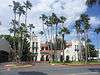 |
(#03000276) |
101 N. Main St. 26°12′17″N 98°14′04″W / 26.2048°N 98.234333°W |
McAllen | |
| 3 | Cine El Rey | 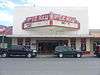 |
(#02000402) |
311 S. 17th St. 26°12′05″N 98°14′17″W / 26.20147°N 98.23804°W |
McAllen | |
| 4 | Cortez Hotel | 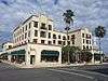 |
(#04001397) |
260 S. Texas Ave. 26°09′33″N 97°59′27″W / 26.15927°N 97.99091°W |
Weslaco | |
| 5 | El Sal Del Rey Archeological District | Upload image | (#79002977) |
Address Restricted 26°32′16″N 98°03′24″W / 26.5379°N 98.0566°W |
Linn | |
| 6 | Mary S. and Gordon Griffin House | 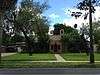 |
(#14000341) |
704 N. 15th Street 26°12′38″N 98°14′03″W / 26.210669°N 98.234119°W |
McAllen | |
| 7 | La Lomita Historic District | 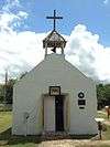 |
(#75002165) |
5 mi (8.0 km). S of Mission on FM 1016 26°09′12″N 98°19′32″W / 26.15324°N 98.3256°W |
Mission | |
| 8 | Lomita Boulevard Commercial Historic District | 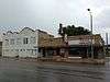 |
(#98001184) |
400 to 700 Blocks N. Conway Blvd. 26°12′40″N 98°19′34″W / 26.211111°N 98.326111°W |
Mission | |
| 9 | Louisiana-Rio Grande Canal Company Irrigation System | 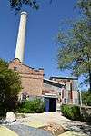 |
(#95001284) |
S. 2nd St. at River Levee 26°05′49″N 98°15′42″W / 26.09689°N 98.26177°W |
Hidalgo | Address is for First pump station. Listings also includes second pump station in McAllen and approximately 45000 acres of canals in southern Hidalgo County. |
| 10 | M and J Nelson Building | 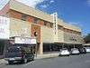 |
(#08000962) |
300-308 S. 14th St. 26°12′05″N 98°14′06″W / 26.201428°N 98.234917°W |
McAllen | |
| 11 | McAllen Ranch | Upload image | (#07000337) |
FM 1017, 13 mi (21 km). W of TX 281 26°37′25″N 98°18′02″W / 26.62359°N 98.3005°W |
Linn | |
| 12 | Sam and Marjorie Miller House | 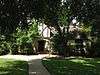 |
(#97000780) |
707 N. 15th St. 26°12′39″N 98°14′04″W / 26.210833°N 98.234444°W |
McAllen | |
| 13 | Mission Canal Company Second Lift Pumphouse |  |
(#02000910) |
6th St. and Canal 26°12′43″N 98°19′51″W / 26.211944°N 98.330833°W |
Mission | |
| 14 | Mission Citrus Growers Union Packing Shed | 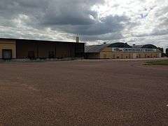 |
(#02000911) |
824 W. Business TX 83 26°12′56″N 98°19′56″W / 26.215556°N 98.332222°W |
Mission | |
| 15 | Oblate Park Historic District | 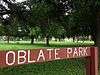 |
(#05001459) |
Roughly bounded by Doherty, Keralum, W. 16th St. and W 10th St. 26°13′13″N 98°19′17″W / 26.220278°N 98.321389°W |
Mission | |
| 16 | Old Hidalgo Courthouse and Buildings | 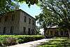 |
(#80004136) |
Flora and 1st Sts. 26°05′57″N 98°15′44″W / 26.09927°N 98.26212°W |
Hidalgo | |
| 17 | Old Hidalgo School | 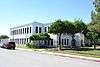 |
(#79002976) |
Flora and 4th Sts. 26°05′54″N 98°15′34″W / 26.098333°N 98.259444°W |
Hidalgo | |
| 18 | Rancho Toluca | Upload image | (#83004513) |
FM 1015 26°04′14″N 97°56′43″W / 26.07049°N 97.9454°W |
Progreso | |
| 19 | Roosevelt School Auditorium and Classroom Addition | 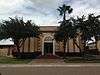 |
(#02000909) |
407 E. 3rd St. 26°12′30″N 98°19′21″W / 26.20823°N 98.32259°W |
Mission | |
| 20 | John Shary Building | Upload image | (#02000907) |
900 Doherty 26°12′53″N 98°19′28″W / 26.21483°N 98.32443°W |
Mission | |
| 21 | Teatro La Paz | 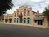 |
(#02000908) |
514,516,518 Doherty 26°12′39″N 98°19′31″W / 26.21095°N 98.32517°W |
Mission | |
| 22 | Valley Fruit Company | |
(#11000897) |
724 N. Cage Blvd. 26°12′06″N 98°10′54″W / 26.20172°N 98.18177°W |
Pharr |
See also
| Wikimedia Commons has media related to National Register of Historic Places in Hidalgo County, Texas. |
References
- ↑ The latitude and longitude information provided in this table was derived originally from the National Register Information System, which has been found to be fairly accurate for about 99% of listings. For about 1% of NRIS original coordinates, experience has shown that one or both coordinates are typos or otherwise extremely far off; some corrections may have been made. A more subtle problem causes many locations to be off by up to 150 yards, depending on location in the country: most NRIS coordinates were derived from tracing out latitude and longitudes off of USGS topographical quadrant maps created under the North American Datum of 1927, which differs from the current, highly accurate WGS84 GPS system used by most on-line maps. Chicago is about right, but NRIS longitudes in Washington are higher by about 4.5 seconds, and are lower by about 2.0 seconds in Maine. Latitudes differ by about 1.0 second in Florida. Some locations in this table may have been corrected to current GPS standards.
- ↑ "National Register of Historic Places: Weekly List Actions". National Park Service, United States Department of the Interior. Retrieved on December 2, 2016.
- ↑ Numbers represent an ordering by significant words. Various colorings, defined here, differentiate National Historic Landmarks and historic districts from other NRHP buildings, structures, sites or objects.
- ↑ National Park Service (2008-04-24). "National Register Information System". National Register of Historic Places. National Park Service.
- ↑ The eight-digit number below each date is the number assigned to each location in the National Register Information System database, which can be viewed by clicking the number.
 |
Brooks County | Kenedy County | | |
| Starr County | |
Willacy County and Cameron County | ||
| ||||
| | ||||
| Mexico |
| Topics | |
|---|---|
| Lists by states |
|
| Lists by insular areas | |
| Lists by associated states | |
| Other areas | |
| |
This article is issued from Wikipedia - version of the 7/2/2016. The text is available under the Creative Commons Attribution/Share Alike but additional terms may apply for the media files.