| [3] |
Name on the Register[4] |
Image |
Date listed[5] |
Location |
City or town |
Description |
|---|
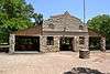
| 1 |
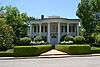
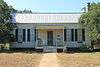
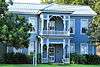
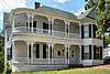
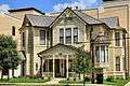
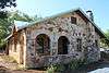
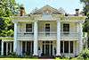
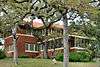
Barber House |
|
000000001983-08-26-0000August 26, 1983
(#83004489) |
1000 Burleson St.
29°52′45″N 97°57′13″W / 29.87904°N 97.95365°W / 29.87904; -97.95365 (Barber House) |
San Marcos |
|
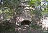
| 2 |
Belger-Cahill Lime Kiln |
|
000000001983-08-26-0000August 26, 1983
(#83004490) |
Lime Kiln Rd.
29°53′59″N 97°55′35″W / 29.899722°N 97.926389°W / 29.899722; -97.926389 (Belger-Cahill Lime Kiln) |
San Marcos |
|
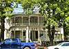
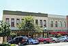
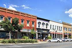
| 3 |
Belvin Street Historic District |
|
000000001983-12-01-0000December 1, 1983
(#83003792) |
700, 800, 900 blocks of Belvin St., and 227 Mitchell St.
29°52′44″N 97°57′03″W / 29.878889°N 97.950833°W / 29.878889; -97.950833 (Belvin Street Historic District) |
San Marcos |
|
| 4 |
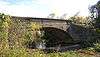
Bunton Branch Bridge |
|
000000002002-02-19-0000February 19, 2002
(#02000086) |
Cty. Rd. 210, approx. 0.2 mi (0.32 km). NW of jct. with IH-35 at Bunton Overpass
30°01′05″N 97°51′31″W / 30.018056°N 97.858611°W / 30.018056; -97.858611 (Bunton Branch Bridge) |
Kyle |
|
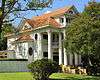
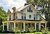
| 5 |
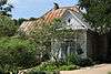
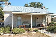
Burleson-Knispel House |
Upload image |
000000001979-08-03-0000August 3, 1979
(#79002975) |
1.5 mi (2.4 km). N of San Marcos on Lime Kiln Rd
29°54′43″N 97°55′43″W / 29.911944°N 97.928611°W / 29.911944; -97.928611 (Burleson-Knispel House) |
San Marcos |
|
| 6 |
Caldwell House |
|
000000001983-08-26-0000August 26, 1983
(#83004491) |
619 Maury St.
29°53′00″N 97°57′05″W / 29.883333°N 97.951389°W / 29.883333; -97.951389 (Caldwell House) |
San Marcos |
|
| 7 |
Camp Ben McCulloch |
|
000000002004-10-12-0000October 12, 2004
(#04001151) |
18301 Ranch Rd. 1826
30°07′45″N 98°00′52″W / 30.129167°N 98.014444°W / 30.129167; -98.014444 (Camp Ben McCulloch) |
Driftwood |
|
| 8 |
Cape House |
|
000000001983-08-26-0000August 26, 1983
(#83004492) |
316 W. Hopkins St.
29°52′59″N 97°56′40″W / 29.8830°N 97.9445°W / 29.8830; -97.9445 (Cape House) |
San Marcos |
|
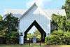
| 9 |
Cemetery Chapel, San Marcos Cemetery |
|
000000001983-12-01-0000December 1, 1983
(#83003793) |
TX 12
29°53′12″N 97°57′27″W / 29.88676°N 97.9576°W / 29.88676; -97.9576 (Cemetery Chapel, San Marcos Cemetery) |
San Marcos |
|
| 10 |
Cen-Tex Wool Mill Historic District |
Upload image |
000000002005-06-01-0000June 1, 2005
(#05000520) |
101 Uhland Rd.
29°54′02″N 97°54′59″W / 29.900556°N 97.916389°W / 29.900556; -97.916389 (Cen-Tex Wool Mill Historic District) |
San Marcos |
|
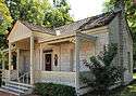
| 11 |
Cock House |
|
000000001973-04-02-0000April 2, 1973
(#73001966) |
400 E. Hopkins St.
29°53′00″N 97°56′14″W / 29.88335°N 97.93725°W / 29.88335; -97.93725 (Cock House) |
San Marcos |
|
| 12 |
John R. Dobie House |
|
000000001992-08-18-0000August 18, 1992
(#92001024) |
282 Old Kyle Rd.
29°59′48″N 98°05′34″W / 29.996667°N 98.092778°W / 29.996667; -98.092778 (John R. Dobie House) |
Wimberley |
|
| 13 |
Cora Jackman Donalson House |
|
000000002010-10-28-0000October 28, 2010
(#10000864) |
200 S. Sledge St.
29°59′18″N 97°52′47″W / 29.9883°N 97.8798°W / 29.9883; -97.8798 (Cora Jackman Donalson House) |
Kyle |
Rural Properties of Hays County, Texas MPS
|
| 14 |
Downtown Buda Historic District |
|
000000002003-11-07-0000November 7, 2003
(#03001126) |
Roughly bounded by Elm St., Main St., China St., and Austin St.
30°04′54″N 97°50′36″W / 30.0818°N 97.8432°W / 30.0818; -97.8432 (Downtown Buda Historic District) |
Buda |
|
| 15 |
Dripping Springs Downtown Historic District |
|
000000002013-07-17-0000July 17, 2013
(#13000504) |
100-500 blk. Mercer, 100 blk. Wallace, 100 blk. San Marcos & 101 College Sts., 101-103 Old Fitzhugh Rd.
30°11′34″N 98°05′21″W / 30.19281°N 98.0892°W / 30.19281; -98.0892 (Dripping Springs Downtown Historic District) |
Dripping Springs |
|
| 16 |
Episcopalian Rectory |
|
000000001983-08-26-0000August 26, 1983
(#83004493) |
225 W. Hopkins St.
29°52′57″N 97°56′37″W / 29.8826°N 97.9436°W / 29.8826; -97.9436 (Episcopalian Rectory) |
San Marcos |
|
| 17 |
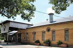
Farmers Union Gin Company |
|
000000001983-08-26-0000August 26, 1983
(#83004494) |
120 Grove St.
29°52′33″N 97°56′25″W / 29.875833°N 97.940278°W / 29.875833; -97.940278 (Farmers Union Gin Company) |
San Marcos |
|
| 18 |
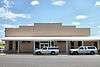
Fire Station and City Hall |
|
000000001983-08-26-0000August 26, 1983
(#83004495) |
224 N. Guadalupe St.
29°53′02″N 97°56′28″W / 29.883889°N 97.941111°W / 29.883889; -97.941111 (Fire Station and City Hall) |
San Marcos |
|
| 19 |
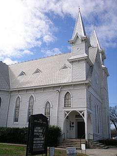
First United Methodist Church |
|
000000001974-11-08-0000November 8, 1974
(#74002269) |
129 W. Hutchison
29°53′02″N 97°56′34″W / 29.883889°N 97.942778°W / 29.883889; -97.942778 (First United Methodist Church) |
San Marcos |
|
| 20 |
Fisher Hall |
Upload image |
000000001983-08-26-0000August 26, 1983
(#83004496) |
1132 Belvin St.
29°52′35″N 97°57′16″W / 29.876389°N 97.954444°W / 29.876389; -97.954444 (Fisher Hall) |
San Marcos |
Destroyed by fire in 2007[6]
|
| 21 |
Fort Street Presbyterian Church |
|
000000001984-03-23-0000March 23, 1984
(#84001860) |
516 W. Hopkins St.
29°52′55″N 97°56′48″W / 29.8819°N 97.9467°W / 29.8819; -97.9467 (Fort Street Presbyterian Church) |
San Marcos |
|
| 22 |
Harry Freeman Site |
Upload image |
000000001978-11-07-0000November 7, 1978
(#78002953) |
Address Restricted
|
San Marcos |
|
| 23 |
Goforth-Harris House |
|
000000001983-08-26-0000August 26, 1983
(#83004497) |
401 Comanche St.
29°53′06″N 97°56′40″W / 29.885°N 97.944444°W / 29.885; -97.944444 (Goforth-Harris House) |
San Marcos |
|
| 24 |
Isham Jones Good Homestead |
Upload image |
000000002004-08-20-0000August 20, 2004
(#04000896) |
13401 Evergreen Way
30°10′09″N 97°57′43″W / 30.169167°N 97.961944°W / 30.169167; -97.961944 (Isham Jones Good Homestead) |
Austin |
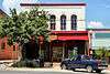
|
| 25 |
Green and Faris Buildings |
|
000000001983-08-26-0000August 26, 1983
(#83004498) |
136-144 E. San Antonio St.
29°52′56″N 97°56′25″W / 29.8821°N 97.9402°W / 29.8821; -97.9402 (Green and Faris Buildings) |
San Marcos |
|
| 26 |
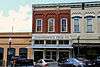
Hardy-Williams Building |
|
000000001983-08-26-0000August 26, 1983
(#83004499) |
127 E. Hopkins St.
29°53′00″N 97°56′27″W / 29.8833°N 97.9407°W / 29.8833; -97.9407 (Hardy-Williams Building) |
San Marcos |
|
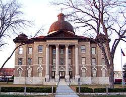
| 27 |
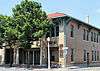
Hays County Courthouse |
|
000000001980-05-23-0000May 23, 1980
(#80004134) |
Public Sq.
29°52′56″N 97°56′25″W / 29.882222°N 97.940278°W / 29.882222; -97.940278 (Hays County Courthouse) |
San Marcos |
|
| 28 |
Hays County Courthouse Historic District |
|
000000001992-09-10-0000September 10, 1992
(#92001233) |
Roughly bounded by the alleys behind N. Guadalupe, E. Hopkins, N. LBJ and E. San Antonio Sts.
29°52′57″N 97°56′25″W / 29.8825°N 97.940278°W / 29.8825; -97.940278 (Hays County Courthouse Historic District) |
San Marcos |
|
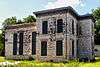
| 29 |
Hays County Jail |
|
000000001983-08-26-0000August 26, 1983
(#83004500) |
170 S Fredericksburg St.
29°52′50″N 97°56′33″W / 29.88042°N 97.9424°W / 29.88042; -97.9424 (Hays County Jail) |
San Marcos |
|
| 30 |
Heard House |
|
000000001983-08-26-0000August 26, 1983
(#83004501) |
620 W. San Antonio St.
29°52′46″N 97°56′48″W / 29.879444°N 97.946667°W / 29.879444; -97.946667 (Heard House) |
San Marcos |
|
| 31 |
Augusta Hofheinz House |
|
000000001983-08-26-0000August 26, 1983
(#83004502) |
1104 W. Hopkins St.
29°52′35″N 97°57′10″W / 29.8764°N 97.95275°W / 29.8764; -97.95275 (Augusta Hofheinz House) |
San Marcos |
|
| 32 |
Walter Hofheinz House |
|
000000001983-12-01-0000December 1, 1983
(#83003794) |
819 W. Hopkins St.
29°52′42″N 97°57′00″W / 29.87835°N 97.94993°W / 29.87835; -97.94993 (Walter Hofheinz House) |
San Marcos |
|
| 33 |
Hutchison House |
|
000000001983-08-26-0000August 26, 1983
(#83004503) |
LBJ Dr. and University St.
29°53′08″N 97°56′25″W / 29.88565°N 97.9403°W / 29.88565; -97.9403 (Hutchison House) |
San Marcos |
|
| 34 |
Johnson House |
|
000000001983-08-26-0000August 26, 1983
(#83004504) |
1030 Belvin St.
29°52′37″N 97°57′12″W / 29.876944°N 97.953333°W / 29.876944; -97.953333 (Johnson House) |
San Marcos |
|
| 35 |
Kone-Cliett House |
|
000000001983-12-01-0000December 1, 1983
(#83003795) |
724 Burleson St.
29°52′52″N 97°57′05″W / 29.88116°N 97.9513°W / 29.88116; -97.9513 (Kone-Cliett House) |
San Marcos |
|
| 36 |
Kyle City Hall |
|
000000002002-05-22-0000May 22, 2002
(#02000528) |
109 Burleson Rd.
29°59′18″N 97°52′37″W / 29.988333°N 97.876944°W / 29.988333; -97.876944 (Kyle City Hall) |
Kyle |
|
| 37 |
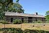
Claiborne Kyle Log House |
|
000000001981-05-28-0000May 28, 1981
(#81000630) |
SW of Kyle
29°57′55″N 97°54′08″W / 29.965278°N 97.902222°W / 29.965278; -97.902222 (Claiborne Kyle Log House) |
Kyle vicinity |
|
| 38 |
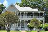
James C. Lane House |
|
000000002010-11-29-0000November 29, 2010
(#10000961) |
306 Wimberley Square
29°59′43″N 98°05′51″W / 29.995278°N 98.0975°W / 29.995278; -98.0975 (James C. Lane House) |
Wimberley |
|
| 39 |
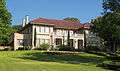
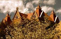
Main Building, Southwest Texas Normal School |
|
000000001983-08-26-0000August 26, 1983
(#83004505) |
Old Main St., Texas State University
29°53′21″N 97°56′19″W / 29.889167°N 97.938611°W / 29.889167; -97.938611 (Main Building, Southwest Texas Normal School) |
San Marcos |
1903 Victorian Gothic building designed by Edward Northcraft; first building of the Southwest Texas State Normal School (now known as Texas State University)[7]
|
| 40 |
McKie-Bass Building |
|
000000001983-12-01-0000December 1, 1983
(#83003797) |
111 N. Guadalupe St.
29°52′57″N 97°56′29″W / 29.8825°N 97.9415°W / 29.8825; -97.9415 (McKie-Bass Building) |
San Marcos |
|
| 41 |
Michaelis Ranch |
Upload image |
000000002003-03-07-0000March 7, 2003
(#02001212) |
3600 FM 150 West
30°01′42″N 97°55′24″W / 30.0284°N 97.923217°W / 30.0284; -97.923217 (Michaelis Ranch) |
Kyle |
|
| 42 |
Moore Grocery Company |
|
000000001983-08-26-0000August 26, 1983
(#83004506) |
101 S. Edward Gary St.
29°52′56″N 97°56′18″W / 29.8821°N 97.9384°W / 29.8821; -97.9384 (Moore Grocery Company) |
San Marcos |
|
| 43 |
Ruskin C. Norman Site (41 HY 86) |
Upload image |
000000001978-11-21-0000November 21, 1978
(#78002954) |
Address Restricted
|
San Marcos |
|
| 44 |
Onion Creek Post Office and Stagecoach House |
|
000000002002-10-27-0000October 27, 2002
(#02001211) |
109 N. Loop 4
30°05′23″N 97°50′13″W / 30.089722°N 97.836944°W / 30.089722; -97.836944 (Onion Creek Post Office and Stagecoach House) |
Buda |
|
| 45 |
Pettey House |
|
000000002008-06-20-0000June 20, 2008
(#08000541) |
714 Burleson St.
29°52′53″N 97°57′03″W / 29.8813°N 97.9509°W / 29.8813; -97.9509 (Pettey House) |
San Marcos |
|
| 46 |
Katherine Anne Porter House |
|
000000002004-08-20-0000August 20, 2004
(#04000893) |
508 W. Center St.
29°59′22″N 97°52′49″W / 29.989444°N 97.880278°W / 29.989444; -97.880278 (Katherine Anne Porter House) |
Kyle |
|
| 47 |
Dr. Joseph M. and Sarah Pound Farmstead |
|
000000001995-07-28-0000July 28, 1995
(#95000929) |
Ranch Rd. 12 N.
30°12′02″N 98°04′50″W / 30.200556°N 98.080556°W / 30.200556; -98.080556 (Dr. Joseph M. and Sarah Pound Farmstead) |
Dripping Springs |
|
| 48 |
Ragsdale-Jackman-Yarbough House |
|
000000001983-08-26-0000August 26, 1983
(#83004507) |
621 W. San Antonio St.
29°52′45″N 97°56′47″W / 29.8791°N 97.9464°W / 29.8791; -97.9464 (Ragsdale-Jackman-Yarbough House) |
San Marcos |
|
| 49 |
Rylander-Kyle House |
|
000000001983-08-26-0000August 26, 1983
(#83004508) |
711 W. San Antonio St.
29°52′43″N 97°56′49″W / 29.8787°N 97.9470°W / 29.8787; -97.9470 (Rylander-Kyle House) |
San Marcos |
|
| 50 |
San Marcos Milling Company |
|
000000001983-12-01-0000December 1, 1983
(#83003799) |
Nicola Alley
29°52′33″N 97°56′18″W / 29.875833°N 97.938333°W / 29.875833; -97.938333 (San Marcos Milling Company) |
San Marcos |
|
| 51 |
San Marcos Telephone Company |
|
000000001983-08-26-0000August 26, 1983
(#83004509) |
138 W. San Antonio St.
29°52′56″N 97°56′32″W / 29.882222°N 97.942361°W / 29.882222; -97.942361 (San Marcos Telephone Company) |
San Marcos |
|
| 52 |
Simon Building |
|
000000001983-08-26-0000August 26, 1983
(#83004510) |
124-126 W. Hopkins St.
29°52′59″N 97°56′32″W / 29.8831°N 97.9422°W / 29.8831; -97.9422 (Simon Building) |
San Marcos |
|
| 53 |
Smith House |
|
000000001983-08-26-0000August 26, 1983
(#83004511) |
322 Scott St.
29°52′53″N 97°56′59″W / 29.88143°N 97.94984°W / 29.88143; -97.94984 (Smith House) |
San Marcos |
|
| 54 |
Williams-Tarbutton House |
|
000000001983-08-26-0000August 26, 1983
(#83004512) |
626 Lindsey St.
29°52′57″N 97°57′04″W / 29.8826°N 97.9511°W / 29.8826; -97.9511 (Williams-Tarbutton House) |
San Marcos |
|
| 55 |
Winters-Wimberley House |
|
000000002002-05-22-0000May 22, 2002
(#02000527) |
14070 Ranch Road 12
29°59′53″N 98°05′54″W / 29.998056°N 98.098333°W / 29.998056; -98.098333 (Winters-Wimberley House) |
Wimberley |
|