National Register of Historic Places listings in Brazoria County, Texas
This is intended to be a complete list of properties and districts listed on the National Register of Historic Places in Brazoria County, Texas. The locations of National Register properties and districts (at least for all showing latitude and longitude coordinates below) may be seen in a map by clicking on "Map of all coordinates".[1]
- This National Park Service list is complete through NPS recent listings posted December 2, 2016.[2]
Current listings
| [3] |
Name on the Register[4] |
Image |
Date listed[5] |
Location |
City or town |
Description |
|---|
| 1 |
Brazoria Bridge |
|
000000001991-06-14-0000June 14, 1991
(#91000783) |
0.9 mi. E of TX 36 on TX 332
29°03′15″N 95°33′25″W / 29.054167°N 95.556944°W / 29.054167; -95.556944 (Brazoria Bridge) |
Brazoria |
|
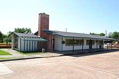
| 2 |
Alden B. Dow Office and Lake Jackson City Hall |
|
000000002010-03-01-0000March 1, 2010
(#10000050) |
101 S. Parking Place
29°02′26″N 95°26′55″W / 29.04069°N 95.44856°W / 29.04069; -95.44856 (Alden B. Dow Office and Lake Jackson City Hall) |
Lake Jackson |
|
| 3 |
Durazno Plantation |
|
000000001980-09-02-0000September 2, 1980
(#80004081) |
S of Jones Creek off TX 36
28°57′22″N 95°26′57″W / 28.956111°N 95.449167°W / 28.956111; -95.449167 (Durazno Plantation) |
Jones Creek |
|
| 4 |
East Columbia Historic District |
|
000000001991-10-28-0000October 28, 1991
(#91001602) |
S. Main St.
29°08′31″N 95°36′54″W / 29.141944°N 95.615°W / 29.141944; -95.615 (East Columbia Historic District) |
East Columbia |
|
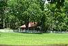
| 5 |
Gazebo for James Richard Marmion |
|
000000002004-10-22-0000October 22, 2004
(#04001173) |
1214 County Rd.
29°02′34″N 95°38′40″W / 29.042778°N 95.644444°W / 29.042778; -95.644444 (Gazebo for James Richard Marmion) |
Sweeny |
Sculpture by Dionicio Rodriguez
|
| 6 |
GEN. C. B. COMSTOCK (dredge) Shipwreck Site |
Upload image |
000000001995-07-06-0000July 6, 1995
(#94001119) |
Address Restricted
|
Surfside Beach |
|
| 7 |
John McCroskey Log House |
|
000000001975-08-28-0000August 28, 1975
(#75001958) |
2 mi. NE of Cedar Lake on Stringfellow Ranch
28°56′22″N 95°36′54″W / 28.939444°N 95.615°W / 28.939444; -95.615 (John McCroskey Log House) |
Cedar Lake |
|
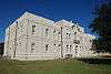
| 8 |
Old Brazoria County Courthouse |
|
000000001979-03-12-0000March 12, 1979
(#79002922) |
Public Sq.
29°10′08″N 95°25′52″W / 29.168889°N 95.431111°W / 29.168889; -95.431111 (Old Brazoria County Courthouse) |
Angleton |
|
| 9 |
Palapa Table for James Richard Marmion |
|
000000002004-10-22-0000October 22, 2004
(#04001172) |
1214 County Rd.
29°02′38″N 95°38′51″W / 29.043889°N 95.6475°W / 29.043889; -95.6475 (Palapa Table for James Richard Marmion) |
Sweeny |
Sculpture by Dionicio Rodriguez
|
| 10 |
Ammon Underwood House |
|
000000001976-06-24-0000June 24, 1976
(#76002011) |
Main St.
29°08′20″N 95°37′03″W / 29.138889°N 95.6175°W / 29.138889; -95.6175 (Ammon Underwood House) |
East Columbia |
|
| 11 |
Varner-Hogg Plantation |
|
000000001980-04-09-0000April 9, 1980
(#80004082) |
2 mi. NE of West Columbia off FM 2852
29°09′47″N 95°38′25″W / 29.163056°N 95.640278°W / 29.163056; -95.640278 (Varner-Hogg Plantation) |
West Columbia |
|
| [3] |
Name on the Register |
Image |
Date listed | Date removed |
Location |
City or town |
Summary |
|---|
| 1 |
Ellerslie Plantation of Texas |
Upload image |
000000001978-12-21-0000December 21, 1978
(#78002898) | Unknown |
SE of Brazoria off TX 36
|
Brazoria |
|
See also
References
- ↑ The latitude and longitude information provided in this table was derived originally from the National Register Information System, which has been found to be fairly accurate for about 99% of listings. For about 1% of NRIS original coordinates, experience has shown that one or both coordinates are typos or otherwise extremely far off; some corrections may have been made. A more subtle problem causes many locations to be off by up to 150 yards, depending on location in the country: most NRIS coordinates were derived from tracing out latitude and longitudes off of USGS topographical quadrant maps created under the North American Datum of 1927, which differs from the current, highly accurate WGS84 GPS system used by most on-line maps. Chicago is about right, but NRIS longitudes in Washington are higher by about 4.5 seconds, and are lower by about 2.0 seconds in Maine. Latitudes differ by about 1.0 second in Florida. Some locations in this table may have been corrected to current GPS standards.
- ↑ "National Register of Historic Places: Weekly List Actions". National Park Service, United States Department of the Interior. Retrieved on December 2, 2016.
- 1 2 Numbers represent an ordering by significant words. Various colorings, defined here, differentiate National Historic Landmarks and historic districts from other NRHP buildings, structures, sites or objects.
- ↑ National Park Service (2008-04-24). "National Register Information System". National Register of Historic Places. National Park Service.
- ↑ The eight-digit number below each date is the number assigned to each location in the National Register Information System database, which can be viewed by clicking the number.
|
|---|
|
| Topics | |
|---|
|
| Lists by states | |
|---|
|
| Lists by insular areas | |
|---|
|
| Lists by associated states | |
|---|
|
| Other areas | |
|---|
|
-
 Portal Portal
-
 WikiProject WikiProject
|
.jpg)
.jpg)
.jpg)
.jpg)
.jpg)
.jpg)
.jpg)
