National Register of Historic Places listings in Anderson County, Texas
List of Registered Historic Places in Anderson County, Texas
This is intended to be a complete list of properties and districts listed on the National Register of Historic Places in Anderson County, Texas. The locations of National Register properties and districts (at least for all showing latitude and longitude coordinates below) may be seen in a map by clicking on "Map of all coordinates".[1]
- This National Park Service list is complete through NPS recent listings posted December 2, 2016.[2]
| [3] | Name on the Register[4] | Image | Date listed[5] | Location | City or town | Description |
|---|---|---|---|---|---|---|
| 1 | Anderson Camp Ground | .jpg) |
(#82001735) |
W of Brushy Creek on Farm to Market Road 837 31°57′14″N 95°37′23″W / 31.953889°N 95.623056°W |
Brushy Creek | aka Brushy Creek Arbor and United Methodist Church |
| 2 | Anderson County Courthouse | 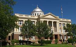 |
(#92001256) |
1 Public Sq. 31°45′54″N 95°37′34″W / 31.765°N 95.626111°W |
Palestine | |
| 3 | Anderson County Jail | 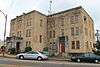 |
(#98000692) |
704 Avenue A 31°45′50″N 95°37′36″W / 31.763889°N 95.626667°W |
Palestine | |
| 4 | William and Caroline Broyles House | 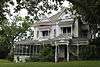 |
(#88002614) |
1305 S. Sycamore St. 31°44′52″N 95°37′44″W / 31.747778°N 95.628889°W |
Palestine | aka The Broyles House |
| 5 | Denby Building | 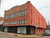 |
(#98000694) |
201 W. Crawford St. 31°45′47″N 95°37′56″W / 31.763056°N 95.632222°W |
Palestine | |
| 6 | G. E. Dilley Building | .jpg) |
(#98000698) |
503 W. Main St. 31°45′44″N 95°38′05″W / 31.762222°N 95.634722°W |
Palestine | |
| 7 | First Presbyterian Church | .jpg) |
(#98000695) |
406 Avenue A 31°45′45″N 95°37′44″W / 31.7625°N 95.628889°W |
Palestine | |
| 8 | Freeman Farm | .jpg) |
(#00000656) |
Co. Rd. 323, 3 miles SE of Frankston 31°59′38″N 95°29′53″W / 31.993889°N 95.498056°W |
Frankston | aka Kickapoo Farm, Freeman Plantation |
| 9 | Gatewood-Shelton Gin | 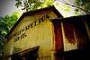 |
(#98000637) |
304 E. Crawford 31°45′50″N 95°37′41″W / 31.763889°N 95.628056°W |
Palestine | |
| 10 | Howard House | 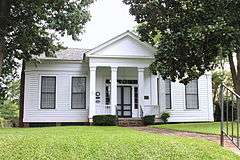 |
(#93000072) |
1011 N. Perry St. 31°46′11″N 95°37′34″W / 31.769722°N 95.626111°W |
Palestine | |
| 11 | Lincoln High School | Upload image | (#98000636) |
920 W. Swantz St. 31°45′20″N 95°38′26″W / 31.755556°N 95.640556°W |
Palestine | Burned in 1996. Demolished. |
| 12 | Link House | .jpg) |
(#80004073) |
925 N. Link St. 31°46′06″N 95°37′46″W / 31.76847°N 95.6294°W |
Palestine | aka Link-Bunton House |
| 13 | Michaux Park Historic District | .jpg) |
(#04000380) |
Roughly bounded by S. Micheaux St., Jolly St., Crokett Rd., Rogers St., and E Park Ave. 31°45′16″N 95°37′32″W / 31.7545°N 95.6256°W |
Palestine | Consists of 295 buildings |
| 14 | Mount Vernon African Methodist Episcopal Church | .jpg) |
(#98000635) |
913 E. Calhoun St. 31°46′05″N 95°37′22″W / 31.768056°N 95.622778°W |
Palestine | |
| 15 | North Side Historic District | .jpg) |
(#98000825) |
Roughly bounded by Kolsted, N. Perry, W. Green, and N. Conrad Sts. 31°46′07″N 95°37′53″W / 31.768611°N 95.631389°W |
Palestine | Consists of 135 buildings |
| 16 | Old Town Residential Historic District | 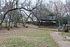 |
(#06000509) |
Roughly surrounded by Lacey St. 31°46′02″N 95°37′22″W / 31.767222°N 95.622778°W |
Palestine | Consists of 45 buildings |
| 17 | Pace McDonald Site | Upload image | (#82004488) |
Address Restricted |
Palestine | 41AN51 |
| 18 | Palestine Carnegie Library | 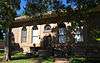 |
(#88001944) |
502 N. Queen St. 31°45′48″N 95°38′04″W / 31.763333°N 95.634444°W |
Palestine | |
| 19 | Palestine High School |  |
(#86002295) |
400 Micheaux Ave. 31°45′29″N 95°37′38″W / 31.758056°N 95.627222°W |
Palestine | currently the Museum for East Texas Culture |
| 20 | Post Office-Palestine | 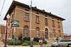 |
(#98000693) |
101 E. Oak St. 31°45′46″N 95°37′52″W / 31.76281°N 95.63120°W |
Palestine | |
| 21 | John H Reagan Monument |  |
(#98000633) |
Reagan Park; vicinity of Park and Crockett Sts. 31°45′28″N 95°37′31″W / 31.75781°N 95.62530°W |
Palestine | |
| 22 | Redlands Hotel | .jpg) |
(#98000634) |
400 N. Queen St. 31°45′46″N 95°38′04″W / 31.76287°N 95.63436°W |
Palestine | |
| 23 | Robinson Bank Building | 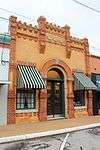 |
(#98000691) |
213 W. Main St. 31°45′44″N 95°37′58″W / 31.762222°N 95.632778°W |
Palestine | |
| 24 | Sacred Heart Catholic Church and School | .jpg) |
(#79002909) |
503 N. Queen St. 31°45′45″N 95°38′04″W / 31.7625°N 95.634444°W |
Palestine | |
| 25 | A. C. Saunders Site | Upload image | (#82004487) |
Address Restricted |
Frankston | 41AN19 |
| 26 | South Side Historic District | .jpg) |
(#98000826) |
Roughly bounded by W. Colorado, and S. Michaux Sts., and Union Pacific Railroad Tracks 31°45′21″N 95°37′50″W / 31.755833°N 95.630556°W |
Palestine | Consists of 189 buildings |
| 27 | Texas & Pacific Steam Locomotive No. 610 | 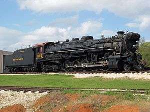 |
(#77001477) |
Park Road 70 31°44′28″N 95°34′16″W / 31.74118°N 95.5712°W |
Palestine |
See also
| Wikimedia Commons has media related to National Register of Historic Places in Anderson County, Texas. |
References
- ↑ The latitude and longitude information provided in this table was derived originally from the National Register Information System, which has been found to be fairly accurate for about 99% of listings. For about 1% of NRIS original coordinates, experience has shown that one or both coordinates are typos or otherwise extremely far off; some corrections may have been made. A more subtle problem causes many locations to be off by up to 150 yards, depending on location in the country: most NRIS coordinates were derived from tracing out latitude and longitudes off of USGS topographical quadrant maps created under the North American Datum of 1927, which differs from the current, highly accurate WGS84 GPS system used by most on-line maps. Chicago is about right, but NRIS longitudes in Washington are higher by about 4.5 seconds, and are lower by about 2.0 seconds in Maine. Latitudes differ by about 1.0 second in Florida. Some locations in this table may have been corrected to current GPS standards.
- ↑ "National Register of Historic Places: Weekly List Actions". National Park Service, United States Department of the Interior. Retrieved on December 2, 2016.
- ↑ Numbers represent an ordering by significant words. Various colorings, defined here, differentiate National Historic Landmarks and historic districts from other NRHP buildings, structures, sites or objects.
- ↑ National Park Service (2008-04-24). "National Register Information System". National Register of Historic Places. National Park Service.
- ↑ The eight-digit number below each date is the number assigned to each location in the National Register Information System database, which can be viewed by clicking the number.
 |
Henderson County | | ||
| Freestone County | |
Cherokee County | ||
| ||||
| | ||||
| Leon County | Houston County |
| Topics | |
|---|---|
| Lists by states |
|
| Lists by insular areas | |
| Lists by associated states | |
| Other areas | |
| |
This article is issued from Wikipedia - version of the 9/7/2016. The text is available under the Creative Commons Attribution/Share Alike but additional terms may apply for the media files.