National Register of Historic Places listings in Hill County, Texas
List of Registered Historic Places in Hill County, Texas
This is intended to be a complete list of properties and districts listed on the National Register of Historic Places in Hill County, Texas. The locations of National Register properties and districts (at least for all showing latitude and longitude coordinates below) may be seen in a map by clicking on "Map of all coordinates".[1]
- This National Park Service list is complete through NPS recent listings posted December 2, 2016.[2]
| [3] | Name on the Register[4] | Image | Date listed[5] | Location | City or town | Description |
|---|---|---|---|---|---|---|
| 1 | J. T. Baker Farmstead | Upload image | (#92000138) |
1.2 mi (1.9 km). N of Blum between TX 174 and the Nolan R. 32°09′30″N 97°23′18″W / 32.158333°N 97.388333°W |
Blum | |
| 2 | Bear Creek Shelter Site | Upload image | (#78002955) |
Address Restricted |
Huron | |
| 3 | Buzzard Cave | Upload image | (#74002270) |
Address Restricted |
Lake Whitney | |
| 4 | Farmers National Bank | 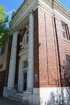 |
(#84001871) |
68 W. Elm St. 32°00′37″N 97°07′51″W / 32.010278°N 97.130833°W |
Hillsboro | |
| 5 | Gebhardt Bakery | 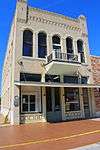 |
(#84001873) |
119 E. Franklin St. 32°00′42″N 97°07′44″W / 32.011667°N 97.128889°W |
Hillsboro | |
| 6 | Grimes Garage | 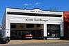 |
(#84001875) |
110 N. Waco St. 32°00′44″N 97°07′47″W / 32.012222°N 97.129722°W |
Hillsboro | |
| 7 | Grimes House | 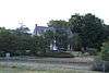 |
(#84001877) |
Country Club Rd. and Corporation St. 32°00′46″N 97°06′51″W / 32.012778°N 97.114167°W |
Hillsboro | |
| 8 | Hill County Courthouse |  |
(#71000939) |
Courthouse Sq. 32°00′40″N 97°07′50″W / 32.011111°N 97.130556°W |
Hillsboro | |
| 9 | Hill County Jail | 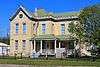 |
(#81000631) |
N. Waco St. 32°00′51″N 97°07′46″W / 32.014167°N 97.129444°W |
Hillsboro | |
| 10 | Hillsboro Cotton Mills | Upload image | (#84001878) |
220 N. Houston St. 32°00′46″N 97°08′05″W / 32.012778°N 97.134722°W |
Hillsboro | Demolished |
| 11 | Hillsboro Residential Historic District | 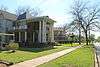 |
(#84001879) |
Roughly bounded by Country Club Rd., Thompson, Corsicana, Pleasant, Franklin, and Elm Sts. 32°00′46″N 97°07′14″W / 32.012778°N 97.120556°W |
Hillsboro | |
| 12 | Kyle Shelter | Upload image | (#74002078) |
Address Restricted |
Lake Whitney Estates | |
| 13 | McKenzie Site | Upload image | (#77001451) |
Address Restricted |
Hillsboro | |
| 14 | Missouri-Kansas-Texas Company Railroad Station | 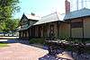 |
(#79002978) |
Covington St. 32°00′46″N 97°07′52″W / 32.012778°N 97.131111°W |
Hillsboro | |
| 15 | Nolan River Bridge 303-A of the Gulf, Colorado and Santa Fe Railway | 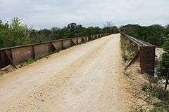 |
(#12001001) |
Cty. Rd. 1127 at Nolan R. 32°08′50″N 97°23′49″W / 32.14733°N 97.39693°W |
Blum | |
| 16 | Old Rock Saloon | 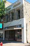 |
(#84001881) |
58 W. Elm St. 32°00′37″N 97°07′49″W / 32.010278°N 97.130278°W |
Hillsboro | |
| 17 | Pictograph Cave | Upload image | (#74002079) |
Address Restricted |
Lake Whitney | |
| 18 | Sheep Cave | Upload image | (#74002077) |
Address Restricted |
Blum | |
| 19 | Sturgis National Bank | 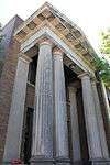 |
(#84001889) |
S. Waco and W. Elm Sts. 32°00′37″N 97°07′48″W / 32.010278°N 97.13°W |
Hillsboro | |
| 20 | Tarlton Building |  |
(#84001892) |
110 E. Franklin St. 32°00′41″N 97°07′44″W / 32.011389°N 97.128889°W |
Hillsboro | |
| 21 | Joe E. Turner House | 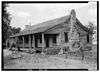 |
(#77001452) |
3 mi (4.8 km). E of Itasca on SR 934 32°10′22″N 97°05′30″W / 32.172778°N 97.091667°W |
Itasca | |
| 22 | U.S. Post Office | 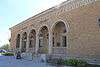 |
(#84001894) |
118 S. Waco St. 32°00′35″N 97°07′48″W / 32.009722°N 97.13°W |
Hillsboro | |
| 23 | Western Union Building | 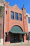 |
(#84001896) |
107 S. Covington St. 32°00′42″N 97°07′44″W / 32.011667°N 97.128889°W |
Hillsboro |
See also
| Wikimedia Commons has media related to National Register of Historic Places in Hill County, Texas. |
References
- ↑ The latitude and longitude information provided in this table was derived originally from the National Register Information System, which has been found to be fairly accurate for about 99% of listings. For about 1% of NRIS original coordinates, experience has shown that one or both coordinates are typos or otherwise extremely far off; some corrections may have been made. A more subtle problem causes many locations to be off by up to 150 yards, depending on location in the country: most NRIS coordinates were derived from tracing out latitude and longitudes off of USGS topographical quadrant maps created under the North American Datum of 1927, which differs from the current, highly accurate WGS84 GPS system used by most on-line maps. Chicago is about right, but NRIS longitudes in Washington are higher by about 4.5 seconds, and are lower by about 2.0 seconds in Maine. Latitudes differ by about 1.0 second in Florida. Some locations in this table may have been corrected to current GPS standards.
- ↑ "National Register of Historic Places: Weekly List Actions". National Park Service, United States Department of the Interior. Retrieved on December 2, 2016.
- ↑ Numbers represent an ordering by significant words. Various colorings, defined here, differentiate National Historic Landmarks and historic districts from other NRHP buildings, structures, sites or objects.
- ↑ National Park Service (2008-04-24). "National Register Information System". National Register of Historic Places. National Park Service.
- ↑ The eight-digit number below each date is the number assigned to each location in the National Register Information System database, which can be viewed by clicking the number.
 |
Johnson County | Ellis County | | |
| Bosque County | |
Navarro County | ||
| ||||
| | ||||
| McLennan County | Limestone County |
| Topics | |
|---|---|
| Lists by states |
|
| Lists by insular areas | |
| Lists by associated states | |
| Other areas | |
| |
This article is issued from Wikipedia - version of the 7/2/2016. The text is available under the Creative Commons Attribution/Share Alike but additional terms may apply for the media files.