National Register of Historic Places listings in Bosque County, Texas
List of Registered Historic Places in Bosque County, Texas
This is intended to be a complete list of properties and districts listed on the National Register of Historic Places in Bosque County, Texas. The locations of National Register properties and districts (at least for all showing latitude and longitude coordinates below) may be seen in a map by clicking on "Map of all coordinates".[1]
- This National Park Service list is complete through NPS recent listings posted December 2, 2016.[2]
Current listings
| [3] | Name on the Register[4] | Image | Date listed[5] | Location | City or town | Description |
|---|---|---|---|---|---|---|
| 1 | J. H. Bekken House | Upload image | (#83003095) |
NW of Clifton 31°47′47″N 97°36′48″W / 31.796389°N 97.613333°W |
Clifton | Part of Upper Settlement Rural Historic District |
| 2 | Bosque County Courthouse | 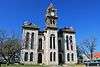 |
(#77001427) |
Public Sq. 31°55′22″N 97°39′26″W / 31.92277°N 97.65734°W |
Meridian | |
| 3 | Brandhagen Houses | Upload image | (#83003096) |
W of Clifton on FM 182 31°46′17″N 97°40′20″W / 31.771389°N 97.672222°W |
Clifton | Part of Upper Settlement Rural Historic District |
| 4 | Bridges-Johnson House |  |
(#79003447) |
Off TX 6, SW of Meridian 31°54′24″N 97°39′54″W / 31.90668°N 97.66510°W |
Meridian | |
| 5 | Brogdon Farm | Upload image | (#83003097) |
W of Clifton 31°47′15″N 97°42′06″W / 31.7875°N 97.701667°W |
Clifton | Part of Upper Settlement Rural Historic District |
| 6 | Bronstad House | Upload image | (#83003098) |
SW of Clifton 31°45′40″N 97°38′32″W / 31.761111°N 97.642222°W |
Clifton | Part of Upper Settlement Rural Historic District |
| 7 | John and Mary Colwick Farm | Upload image | (#83003099) |
SW of Clifton 31°42′37″N 97°41′50″W / 31.710278°N 97.697222°W |
Clifton | Part of Upper Settlement Rural Historic District |
| 8 | Colwick Homestead | Upload image | (#15000835) |
Address Restricted |
Clifton vicinity | |
| 9 | Peder Dahl Farm |  |
(#83003100) |
SW of Clifton on FM 219 31°45′12″N 97°36′23″W / 31.753333°N 97.606389°W |
Clifton | Part of Upper Settlement Rural Historic District |
| 10 | Ellingson Farm | Upload image | (#83003101) |
W of Clifton 31°46′43″N 97°42′40″W / 31.778611°N 97.711111°W |
Clifton | Part of Upper Settlement Rural Historic District |
| 11 | Even and Petrine Erickson Farm | Upload image | (#83003102) |
NW of Clifton 31°52′16″N 97°41′24″W / 31.871111°N 97.69°W |
Clifton | Part of Upper Settlement Rural Historic District |
| 12 | Ole and Elizabeth Finstad Homesite |  |
(#83003103) |
SW of Clifton on FM 219 31°43′47″N 97°43′28″W / 31.72975°N 97.72450°W |
Clifton | Part of Upper Settlement Rural Historic District |
| 13 | First National Bank Building | 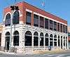 |
(#79002919) |
Main and Morgan Sts. 31°55′24″N 97°39′27″W / 31.92335°N 97.65737°W |
Meridian | |
| 14 | Adolf and Christine Godager Homesite | Upload image | (#83003104) |
NW of Clifton 31°49′38″N 97°45′44″W / 31.82733°N 97.76235°W |
Clifton | Part of Upper Settlement Rural Historic District |
| 15 | Gunsten and Lofise Grimland House | 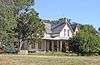 |
(#83003105) |
SW of Clifton on FM 219 31°43′34″N 97°42′38″W / 31.726111°N 97.710556°W |
Clifton | Part of Upper Settlement Rural Historic District |
| 16 | Keddel and Liv Grimland Farm |  |
(#83003106) |
SW of Clifton on FM 219 31°43′30″N 97°42′23″W / 31.725°N 97.706389°W |
Clifton | Part of Upper Settlement Rural Historic District |
| 17 | Hoff-Ulland Farm | Upload image | (#83003107) |
SW of Clifton 31°43′27″N 97°38′02″W / 31.724167°N 97.633889°W |
Clifton | Part of Upper Settlement Rural Historic District |
| 18 | Hog Creek Archeological District | Upload image | (#77001428) |
Address Restricted |
Mosheim | |
| 19 | James Jens and Martha Jenson House | Upload image | (#83003108) |
NW of Clifton on FM 2136 31°49′24″N 97°38′51″W / 31.823333°N 97.6475°W |
Clifton | Part of Upper Settlement Rural Historic District |
| 20 | Christen and Johanne Knudson Farm | Upload image | (#83003109) |
SW of Clifton on FM 219 31°45′24″N 97°38′19″W / 31.756667°N 97.638611°W |
Clifton | Part of Upper Settlement Rural Historic District |
| 21 | A. H. Lahlum House | Upload image | (#83003110) |
SW of Clifton 31°42′19″N 97°40′09″W / 31.705278°N 97.669167°W |
Clifton | Part of Upper Settlement Rural Historic District |
| 22 | Martin Larson House | Upload image | (#83003111) |
SW of Clifton 31°44′10″N 97°45′43″W / 31.736111°N 97.761944°W |
Clifton | Part of Upper Settlement Rural Historic District |
| 23 | Eric and Martha Linberg Farm | Upload image | (#83003112) |
W of Clifton 31°47′06″N 97°40′39″W / 31.785°N 97.6775°W |
Clifton | Part of Upper Settlement Rural Historic District |
| 24 | Lumpkin Building | 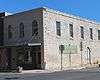 |
(#98000355) |
101 Main St. 31°55′24″N 97°39′25″W / 31.92345°N 97.65703°W |
Meridian | |
| 25 | Norway Mill |  |
(#83003113) |
SW of Clifton on FM 182 31°41′36″N 97°39′24″W / 31.693333°N 97.656667°W |
Clifton | Part of Upper Settlement Rural Historic District |
| 26 | Joseph and Anna Olson Farm | Upload image | (#83003114) |
SW of Clifton on FM 182 31°45′12″N 97°39′36″W / 31.75335°N 97.66°W |
Clifton | Part of Upper Settlement Rural Historic District |
| 27 | Olson-Hanson Farm |  |
(#83003115) |
SW of Clifton on FM 219 31°44′47″N 97°39′13″W / 31.746389°N 97.653611°W |
Clifton | Part of Upper Settlement Rural Historic District |
| 28 | Olson-Nelson Farm | Upload image | (#83003116) |
W of Clifton 31°47′24″N 97°39′44″W / 31.79°N 97.662222°W |
Clifton | Part of Upper Settlement Rural Historic District |
| 29 | John Pederson Farm | Upload image | (#83003117) |
SW of Clifton on FM 219 31°43′40″N 97°43′07″W / 31.72782°N 97.71874°W |
Clifton | Part of Upper Settlement Rural Historic District |
| 30 | Ole and Ann Pierson Farm | Upload image | (#83003118) |
W of Clifton 31°45′37″N 97°43′05″W / 31.760278°N 97.718056°W |
Clifton | Part of Upper Settlement Rural Historic District |
| 31 | Carl and Sedsel Questad Farm | Upload image | (#83003119) |
W of Clifton 31°46′39″N 97°40′50″W / 31.7775°N 97.680556°W |
Clifton | Part of Upper Settlement Rural Historic District |
| 32 | Reeder-Omenson Farm |  |
(#83003120) |
SW of Clifton on FM 182 31°41′31″N 97°39′30″W / 31.691944°N 97.658333°W |
Clifton | Part of Upper Settlement Rural Historic District |
| 33 | Hans and Berthe Reierson House |  |
(#83003121) |
SW of Clifton 31°45′04″N 97°44′49″W / 31.751111°N 97.746944°W |
Clifton | Part of Upper Settlement Rural Historic District |
| 34 | Jens and Kari Ringness Farm |  |
(#83003122) |
Sw of Clifton on FM 219 31°43′23″N 97°41′41″W / 31.723056°N 97.694722°W |
Clifton | Part of Upper Settlement Rural Historic District |
| 35 | Tom and Martha Rogstad Farm | Upload image | (#83003123) |
W of Clifton 31°46′04″N 97°46′39″W / 31.767778°N 97.7775°W |
Clifton | Part of Upper Settlement Rural Historic District |
| 36 | Tobias and Wilhelmine Schultz Farm | Upload image | (#83003124) |
SW of Clifton 31°44′50″N 97°44′42″W / 31.747222°N 97.745°W |
Clifton | Part of Upper Settlement Rural Historic District |
| 37 | Gunarus and Ingerborg Shefstad House |  |
(#83003125) |
N of Clifton 31°47′44″N 97°35′13″W / 31.795556°N 97.586944°W |
Clifton | Part of Upper Settlement Rural Historic District |
| 38 | Upper Settlement Rural Historic District |  |
(#83003126) |
E of Granfills Gap off TX 22 31°47′02″N 97°45′58″W / 31.783889°N 97.766111°W |
Cranfills Gap | |
| 39 | Wilson Homesite | Upload image | (#83003127) |
W of Clifton 31°46′38″N 97°37′39″W / 31.77728°N 97.62760°W |
Clifton | Part of Upper Settlement Rural Historic District |
Former listing
| [3] | Name on the Register | Image | Date listed | Date removed | Location | City or town | Summary |
|---|---|---|---|---|---|---|---|
| 1 | Bosque County Jail | Upload image | (#79002918) | 203 E. Morgan 31°55′24″N 97°39′21″W / 31.923333°N 97.655833°W |
Meridian |
See also
| Wikimedia Commons has media related to National Register of Historic Places in Bosque County, Texas. |
References
- ↑ The latitude and longitude information provided in this table was derived originally from the National Register Information System, which has been found to be fairly accurate for about 99% of listings. For about 1% of NRIS original coordinates, experience has shown that one or both coordinates are typos or otherwise extremely far off; some corrections may have been made. A more subtle problem causes many locations to be off by up to 150 yards, depending on location in the country: most NRIS coordinates were derived from tracing out latitude and longitudes off of USGS topographical quadrant maps created under the North American Datum of 1927, which differs from the current, highly accurate WGS84 GPS system used by most on-line maps. Chicago is about right, but NRIS longitudes in Washington are higher by about 4.5 seconds, and are lower by about 2.0 seconds in Maine. Latitudes differ by about 1.0 second in Florida. Some locations in this table may have been corrected to current GPS standards.
- ↑ "National Register of Historic Places: Weekly List Actions". National Park Service, United States Department of the Interior. Retrieved on December 2, 2016.
- 1 2 Numbers represent an ordering by significant words. Various colorings, defined here, differentiate National Historic Landmarks and historic districts from other NRHP buildings, structures, sites or objects.
- ↑ National Park Service (2008-04-24). "National Register Information System". National Register of Historic Places. National Park Service.
- ↑ The eight-digit number below each date is the number assigned to each location in the National Register Information System database, which can be viewed by clicking the number.
| Topics | |
|---|---|
| Lists by states |
|
| Lists by insular areas | |
| Lists by associated states | |
| Other areas | |
| |
This article is issued from Wikipedia - version of the 10/4/2016. The text is available under the Creative Commons Attribution/Share Alike but additional terms may apply for the media files.