Devil's Garden (Grand Staircase-Escalante National Monument)


The Devil's Garden of the Grand Staircase-Escalante National Monument (GSENM) in south central Utah, the United States, is a natural desert area featuring hoodoos, natural arches and other sandstone formations. The United States Geological Survey (USGS) designated the name Devils Garden—without an apostrophe according to USGS naming conventions[2]—on December 31, 1979.[1] The area is also known as the Devils Garden Outstanding Natural Area within the National Landscape Conservation System.[3]
The formations in the Devils Garden were created, and continue to be shaped, by various weathering and erosional processes.[4][5] These natural processes have been shaping sandstone layers formed more than 166 million years ago during the Jurassic period's Middle epoch.[6][7]
The Bureau of Land Management (BLM) administers the Devils Garden and the entire GSENM which is the first National Monument assigned to the BLM.[8]
Geography
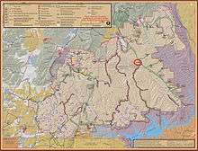
The Devils Garden is located 17 mi (27 km) by road southeast of Escalante, Utah.[9] To the west of the area are the Straight Cliffs which define the eastern edge of the Kaiparowits Plateau. To the east of the area is the Escalante River whose tributaries have formed many slot canyons. To the north is the Dixie National Forest and to the south are the Hole-in-the-Rock and Lake Powell which are located within the Glen Canyon National Recreation Area. The Devils Garden is situated at an elevation of 5,243 ft (1,598 m) above sea level in Garfield County, Utah.[1][10] The area measures 640 acres[11] which is equal to 1 square mile (2.6 square kilometres).
The Hole-in-the-Rock Road is the main access road to the Devils Garden. The unpaved[12] road heads southeast into the National Monument beginning at its intersection with Utah Scenic Byway 12 which is 5 mi (8.0 km) east of Escalante. After traveling 12 mi (19 km) along the Hole-in-the-Rock Road there is a road to the right leading to the Devils Garden area.[9] The majority of the interesting sandstone formations are located in a compact area adjacent to the parking lot.[13]
A climate summary and the current weather forecast for the Escalante area are available in the External links section.
Features
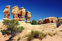
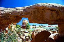
Metate Arch[14] is a slender caprock natural arch[15] located near the center of the Devils Garden at 37°35′4.4″N 111°24′49.5″W / 37.584556°N 111.413750°W. A second arch named Mano Arch[16] is located at 37°35′3.9″N 111°24′48.5″W / 37.584417°N 111.413472°W. There are many hoodoos of varying sizes and shapes, and a group of four prominent but unnamed hoodoos located at 37°35′1.6″N 111°24′49.8″W / 37.583778°N 111.413833°W. The four hoodoos are a popular photographic subject, appearing often in Internet image search results for "Devils Garden" Escalante hoodoos.
There are no marked trails through the area but instead many well-worn footpaths lead to the most interesting formations. Since the Devils Garden is part of a protected area, visitors must not disturb any plants, animals or the delicate cryptobiotic soil. Climbing on or over the natural arches is not permitted by the BLM.[17]
Facilities
Picnic tables and toilet facilities are available.[13] Water is not available and there are no other services provided. Primitive camping is allowed at some points along the Hole-in-the-Rock Road but not at the Devils Garden area or parking lot.[18] A free camping permit is required in advance to camp within the National Monument.[19]
Geology
The rock formations of the area around Escalante have been named by geologists as the Escalante Member of Entrada Sandstone of the San Rafael Group and were formed in the Middle Jurassic Epoch (166 to 174 million years ago).[6][7] The Straight Cliffs Formation of the Kaiparowits Plateau to the west of the Devils Garden were formed during the more recent Cretaceous Period.[20] Paleontologists are interested in the area because the rock formations were deposited when the dinosaurs roamed the Earth. Many dinosaur fossils and tracks have been discovered by scientists working within the boundaries of the GSENM.[21][22][23][24]
The natural arches and other formations were created, and continue to be shaped, by the natural processes of weathering and erosion. Some of the rock layers are composed of a harder caprock material which resists the effects of weathering and erosion. Those caprock layers will remain intact much longer than other less resistant layers which weather and erode away below and around them leaving behind the current arches and hoodoos. Cycles of heat and cold, precipitation, ice, wind and gravity all play a part in the creation of the formations.[4][5]
Daily extreme temperature variations create fractures by repeated expansion and contraction of the rock in a process called thermal stress weathering. The thermal stresses can cause deep cracks that split the rock into separate pieces in an erosional process called thermal exfoliation. Precipitation causes dissolution of the fine crystalline grains that bind the larger particles together, which is known as chemical weathering. Freezing water expands in fractures making them wider and deeper in a process called frost weathering. Gravity exerts a constant downward force that creates new fractures and separates the formations along existing fractures in a process called stress relief exfoliation. High speed winds remove any loose grains from the formations and wind-borne particulates sandblast the surfaces making them smoother.[4][5]
Wilderness
The Devils Garden is also known as a Wilderness Study Area[11] for the purpose of possible wilderness designation; however, wilderness status was not recommended by the BLM's District Manager in an Instant Study Area report[13] submitted to the U.S. Congress in 1991. One of the stated reasons was that the existing roads, parking lot, picnic tables and toilet facilities are all in close proximity to the natural area. A second reason was the likelihood of several groups of people converging at the same time around the main formations of the site, which are located in a 10-acre area adjacent to the parking lot (1.6% of the total designated area of 640 acres). Both of those reasons diminish the wilderness experience of solitude in a remote natural setting.[13]
The Devils Garden remains undeclared as a wilderness area[25] but also remains on a list of BLM Wilderness Study Areas compiled in December 2010.[26]
See also
Major sections of the Grand Staircase-Escalante National Monument:
- Canyons of the Escalante, eastern side
- Kaiparowits Plateau, central part
- Grand Staircase, western side
Roads and features:
- Utah Scenic Byway 12
- Hole-in-the-Rock Road and the rock formation
- Hoodoos and natural arches
- Escalante, Utah and the Escalante River
Notable explorers:
- Silvestre Vélez de Escalante, name origin of city, river and Monument
- Dominguez-Escalante Expedition, skirted but did not enter the Monument in 1776
- San Juan Expedition, traveled through the Monument in 1879-80
- Everett Ruess, a young solo explorer of the Escalante Canyons area in 1934
References
- 1 2 3 "Feature Detail Report for: Devils Garden...Entry Date, Elevation, County and Coordinates". USGS. 31 Dec 1979. Archived from the original on 8 Feb 2016. Retrieved 14 Nov 2016.
- ↑ "Domestic Names - Frequently Asked Questions (FAQs)". USGS. 12 Sep 2016. Archived from the original on 12 Nov 2016. Retrieved 14 Nov 2016.
18. …Since its inception in 1890, the U.S. Board on Geographic Names has discouraged the use of the possessive form…
- ↑ "Feature Detail Report for: Devils Garden Outstanding Natural Area". USGS. 25 Feb 1989. Archived from the original on 8 Feb 2016. Retrieved 14 Nov 2016.
- 1 2 3 "Relevant Processes of Erosion ... based on the natural arch formation chapter in reference Barnes, F. A., Canyon Country Arches and Bridges". The Natural Arch and Bridge Society (NABS). Archived from the original on 8 Nov 2016. Retrieved 14 Nov 2016.
- 1 2 3 Barnes, F. A. (1987). Canyon Country Arches and Bridges. Canyon Country Publications. p. 416. ISBN 0961458615.
- 1 2 "National Geologic Map Database, Geolex — Unit Summary". USGS. 3 Aug 2016. Archived from the original on 14 Nov 2016. Retrieved 14 Nov 2016.
Escalante Member of Entrada Sandstone of San Rafael Group. Age: Jurassic, Middle
- 1 2 "International Chronostratigraphic Chart". International Commission on Stratigraphy. 1 Oct 2016. Archived from the original on 11 Nov 2016. Retrieved 14 Nov 2016.
- ↑ "National Landscape Conservation System". BLM. 21 Dec 2015. Archived from the original on 30 Sep 2016. Retrieved 14 Nov 2016.
GSENM is the first national monument to be managed by the BLM and also the first area to be designated as part of the NLCS
- 1 2 "GSENM Travel Map". BLM (PDF file linked from "blm.gov/ut/st/en/fo/grand_staircase-escalante/Recreation/travel_brochure__.html"). 1 Mar 2016. Archived from the original on 14 Nov 2016. Retrieved 14 Nov 2016.
- ↑ "USGS National Map Viewer". USGS. Archived from the original on 4 Mar 2016. Retrieved 14 Nov 2016.
- 1 2 "Devils Garden Wilderness Study Area". BLM. 1 Nov 2013. Archived from the original on 4 Mar 2016. Retrieved 14 Nov 2016.
Size: 640 acres
- ↑ "Safety Tips". BLM. 24 Mar 2016. Archived from the original on 4 Nov 2016. Retrieved 14 Nov 2016.
Be Prepared for Poor Road Conditions ... Storms can leave dirt roads impassable for several days
- 1 2 3 4 "Utah Wilderness Study Report - 1991: Devils Garden Instant Study Area" (PDF). BLM (PDF file linked from "blm.gov/ut/st/en/prog/blm_special_areas/wilderness_study_areas/ut_wilderness_study.html"). 22 Jul 1983. Archived (PDF) from the original on 1 Oct 2016. Retrieved 14 Nov 2016.
- ↑ "Feature Detail Report for: Metate Arch". USGS. 25 Feb 1989. Archived from the original on 8 Feb 2016. Retrieved 14 Nov 2016.
- ↑ "Metate Arch". The Natural Arch and Bridge Society (NABS). 1 Jan 2003. Archived from the original on 10 Sep 2016. Retrieved 14 Nov 2016.
- ↑ "Feature Detail Report for: Mano Arch". USGS. 27 Mar 1996. Archived from the original on 8 Feb 2016. Retrieved 14 Nov 2016.
- ↑ "Rock Climbing and Canyoneering". BLM. 24 Mar 2016. Archived from the original on 1 Oct 2016. Retrieved 14 Nov 2016.
Climbing and canyoneering are not allowed in archaeological sites, on natural bridges or arches...
- ↑ "Suggested Camping Locations by Region". BLM. 1 Nov 2013. Archived from the original on 11 May 2016. Retrieved 14 Nov 2016.
- ↑ "Permits & Fee Areas". BLM. 24 Mar 2016. Archived from the original on 1 Oct 2016. Retrieved 14 Nov 2016.
- ↑ "Stratigraphy of the Grand Staircase - Escalante National Monument". USGS. 20 Jan 2015. Archived from the original on 4 Mar 2016. Retrieved 14 Nov 2016.
- ↑ "New Dinosaur Discovery Unlike any Other". BLM. 13 Nov 2012. Archived from the original on 1 Oct 2016. Retrieved 14 Nov 2016.
- ↑ "Celebrate National Fossil Day at Grand Staircase-Escalante National Monument". BLM. 11 Jun 2012. Archived from the original on 1 Oct 2016. Retrieved 14 Nov 2016.
One of the last great treasure troves of untapped dinosaur fossils in the continental United States lies within Grand Staircase-Escalante National Monument
- ↑ "Third New Dinosaur Found in Grand Staircase-Escalante National Monument Unveiled". BLM. 21 Sep 2011. Archived from the original on 29 Sep 2016. Retrieved 14 Nov 2016.
- ↑ "Twentymile Wash Dinosaur Megatrackway". BLM. 4 Mar 2011. Archived from the original on 12 May 2016. Retrieved 14 Nov 2016.
- ↑ "BLM Wilderness Areas: Detail Table - Wilderness (note: Devils Garden is not listed)" (PDF). BLM (PDF file linked from "blm.gov/wo/st/en/prog/blm_special_areas/NLCS/Wilderness.html"). 1 Dec 2015. Archived (PDF) from the original on 28 Sep 2016. Retrieved 14 Nov 2016.
- ↑ "BLM Wilderness Study Areas: Detail Table - Wilderness Study Areas" (PDF). BLM (PDF file linked from "blm.gov/wo/st/en/prog/blm_special_areas/NLCS/wilderness_study_areas.html"). 1 Dec 2015. Archived (PDF) from the original on 29 Sep 2016. Retrieved 14 Nov 2016.
External links
| Wikimedia Commons has media related to Devils Garden. |
- Current weather forecast
- Monthly Climate Summary Escalante weather summary since 1901
- Devils Garden on BLM website
- Bureau of Land Management: Grand Staircase-Escalante National Monument
- Grand Staircase Escalante Partners "...the official support organization for Grand Staircase-Escalante National Monument"
- The Natural Arch and Bridge Society (NABS) "A Non-profit Society Supporting the Study, Appreciation, and Preservation of Natural Arches and Bridges"
- Utah Arches photo site "...offers the largest, free access, collection of Utah's natural arches on the internet"
| Topics | |
|---|---|
| Lists by states |
|
| Lists by insular areas | |
| Lists by associated states | |
| Other areas | |
| |