Capitol Reef National Park
| Capitol Reef National Park | |
|---|---|
|
IUCN category II (national park) | |
|
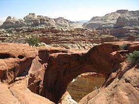
Cassidy Arch | |
 | |
| Location | Wayne, Garfield, Sevier, and Emery counties, Utah, USA |
| Nearest city | Torrey |
| Coordinates | 38°12′0″N 111°10′0″W / 38.20000°N 111.16667°WCoordinates: 38°12′0″N 111°10′0″W / 38.20000°N 111.16667°W |
| Area |
241,904 acres (377.975 sq mi; 97,895 ha; 978.95 km2) 670 acres (1.05 sq mi; 270 ha; 2.7 km2) private[1] |
| Established | December 18, 1971 |
| Visitors | 786,514 (in 2014)[2] |
| Governing body | National Park Service |
| Website | Capitol Reef National Park |
Capitol Reef National Park is a United States National Park, in south-central Utah. The park is approximately 60 miles (97 km) long on its north–south axis but an average of just 6 miles (9.7 km) wide. The park was established in 1971 to preserve 241,904 acres (377.98 sq mi; 97,895.08 ha; 978.95 km2) of desert landscape and is open all year with May through September being the highest visitation months.
Located partially in Wayne County, Utah, the area was originally named "Wayne Wonderland" in the 1920s by local boosters Ephraim P. Pectol and Joseph S. Hickman.[3] Capitol Reef National Park was initially designated a National Monument on August 2, 1937 by President Franklin D. Roosevelt in order to protect the area's colorful canyons, ridges, buttes, and monoliths; however, it was not until 1950 that the area officially opened to the public.[3] Easy road access only came in 1962 with the construction of State Route 24 through the Fremont River Canyon.[4]
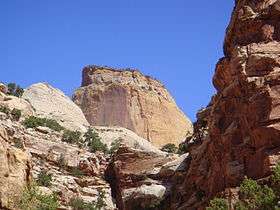
The majority of the nearly 100 mi (160 km) long up-thrust formation called the Waterpocket Fold—a rocky spine extending from Thousand Lake Mountain to Lake Powell—is preserved within the park. Capitol Reef is the name of an especially rugged and spectacular segment of the Waterpocket Fold by the Fremont River.[4] The park was named for a line of cliffs of white Navajo Sandstone with dome formations—similar to the white domes often placed on capitol buildings—that run from the Fremont River to Pleasant Creek on the Waterpocket Fold. The local word reef refers to any rocky barrier to land travel, just as ocean reefs are barriers to sea travel.[5]
Geography

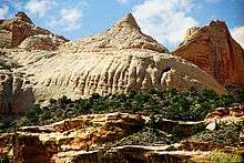


Capitol Reef encompasses the Waterpocket Fold, a warp in the earth's crust that is 65 million years old. It is the largest exposed monocline in North America. In this fold, newer and older layers of earth folded over each other in an S-shape. This warp, probably caused by the same colliding continental plates that created the Rocky Mountains, has weathered and eroded over millennia to expose layers of rock and fossils. The park is filled with brilliantly colored sandstone cliffs, gleaming white domes, and contrasting layers of stone and earth.
The area was named for a line of white domes and cliffs of Navajo Sandstone, each of which looks somewhat like the United States Capitol building, that run from the Fremont River to Pleasant Creek on the Waterpocket Fold.
The fold forms a north-to-south barrier that even today has barely been breached by roads. Early settlers referred to parallel, impassable ridges as "reefs", from which the park gets the second half of its name. The first paved road was constructed through the area in 1962. Today, State Route 24 cuts through the park traveling east and west between Canyonlands National Park and Bryce Canyon National Park, but few other paved roads invade the rugged landscape.
The park is filled with canyons, cliffs, towers, domes, and arches. The Fremont River has cut canyons through parts of the Waterpocket Fold, but most of the park is arid desert country. A scenic drive shows park visitors some of the highlights, but it runs only a few miles from the main highway. Hundreds of miles of trails and unpaved roads lead the more adventurous into the equally scenic backcountry.
History
Native Americans and Mormons
Fremont culture Native Americans lived near the perennial Fremont River in the northern part of the Capitol Reef Waterpocket Fold around 1000 CE. They irrigated crops of lentils, maize, and squash and stored their grain in stone granaries (in part made from the numerous black basalt boulders that litter the area). In the 13th century, all of the Native American cultures in this area underwent sudden change, likely due to a long drought. The Fremont settlements and fields were abandoned.
Many years after the Fremont left, Paiutes moved into the area. These Numic speaking people named the Fremont granaries moki huts and thought they were the homes of a race of tiny people or moki.
In 1872 Alan H. Thompson, a surveyor attached to United States Army Major John Wesley Powell's expedition, crossed the Waterpocket Fold while exploring the area. Geologist Clarence Dutton later spent several summers studying the area's geology. None of these expeditions explored the Waterpocket Fold to any great extent, however. It was, as now, incredibly rugged and forbidding.
Following the American Civil War, officials of The Church of Jesus Christ of Latter-day Saints in Salt Lake City sought to establish missions in the remotest niches of the Intermountain West. In 1866, a quasi-military expedition of Mormons in pursuit of natives penetrated the high valleys to the west. In the 1870s, settlers moved into these valleys, eventually establishing Loa, Fremont, Lyman, Bicknell, and Torrey.[4]
Mormons settled the Fremont River valley in the 1880s and established Junction (later renamed Fruita), Caineville and Aldridge. Fruita prospered, Caineville barely survived, and Aldridge died.[4] In addition to farming, lime was extracted from local limestone and uranium was extracted early in the 20th century. In 1904 the first claim to a uranium mine in the area was staked. The resulting Oyler Mine in Grand Wash produced uranium ore.
By 1920 the work was hard but the life in Fruita was good. No more than ten families at one time were sustained by the fertile flood plain of the Fremont River and the land changed ownership over the years. The area remained isolated.[4] The community was later abandoned and later still some buildings were restored by the National Park Service. Kilns once used to produce lime can still be seen in Sulphur Creek and near the campgrounds on Scenic Drive.
Early protection efforts
Local Ephraim Portman Pectol organized a "booster club" in Torrey in 1921. Pectol pressed a promotional campaign, furnishing stories to be sent to periodicals and newspapers. In his efforts, he was increasingly aided by his brother-in-law, Joseph S. Hickman, who was Wayne County High School principal. In 1924, Hickman extended community involvement in the promotional effort by organizing a Wayne County-wide Wayne Wonderland Club. That same year, the educator was elected to the Utah State Legislature.[6]
In 1933, Pectol was elected to the presidency of the Associated Civics Club of Southern Utah, successor to the Wayne Wonderland Club. The club raised U.S. $150.00 to interest a Salt Lake City photographer in taking a series of promotional photographs. For several years, the photographer – J.E. Broaddus – traveled and lectured on "Wayne Wonderland".[6]
In 1933, Pectol himself was elected to the legislature and almost immediately contacted President Franklin D. Roosevelt and asked for the creation of "Wayne Wonderland National Monument" out of the federal lands comprising the bulk of the Capitol Reef area. Federal agencies began a feasibility study and boundary assessment. Meanwhile, Pectol not only guided the government investigators on numerous trips, but escorted an increasing number of visitors. The lectures of Broaddus were having an effect.[6]
President Roosevelt signed a proclamation creating Capitol Reef National Monument on August 2, 1937. In Proclamation 2246, President Roosevelt set aside 37,711 acres (15,261 ha) of the Capitol Reef area. This comprised an area extending about two miles (3 km) north of present State Route 24 and about 10 mi (16 km) south, just past Capitol Gorge. The Great Depression years were lean ones for the National Park Service (NPS), the new administering agency. Funds for the administration of Capitol Reef were nonexistent; it would be a long time before the first rangers would arrive.[4]
Administration of the monument
Administration of the new monument was placed under the control of Zion National Park.[6] A stone ranger cabin and the Sulphur Creek bridge were built and some road work was performed by the Civilian Conservation Corps and the Works Progress Administration. Historian and printer Charles Kelly came to know NPS officials at Zion well and volunteered to 'watchdog' the park for the NPS. Kelly was officially appointed 'custodian-without-pay' in 1943.[6] He was to work as a volunteer until 1950 when the NPS offered him a civil service appointment as the first superintendent.[6]
During the 1950s Kelly was deeply troubled by NPS management acceding to demands of the U.S. Atomic Energy Commission that Capitol Reef National Monument be opened to uranium prospecting. He felt that the decision had been a mistake and destructive of the long term national interest. As it turned out, there was not enough ore in the monument to be worth mining.[6]
It was not until 1958 that Kelly got additional permanent help in protecting the monument and enforcing regulations; Park Ranger Grant Clark transferred from Zion. The year Clark arrived, fifty-six thousand visitors came to the park and 'Charlie' Kelly retired for the last time, full of years and experiences.[6]
During the 1960s (under the program name Mission 66), NPS areas nationwide received new facilities to meet the demand of mushrooming park visitation. At Capitol Reef, a 53-site campground at Fruita, staff rental housing, and a new visitor center were built, the latter opening in 1966.[4]
Visitation climbed dramatically after the paved, all-weather State Route 24 was built in 1962 through the Fremont River canyon near Fruita. State Route 24 replaced the narrow Capitol Gorge wagon road about 10 mi (16 km) to the south that frequently washed out. The old road has since only been open to foot traffic. In 1967, 146,598 persons visited the park. The staff was also growing.[4]
During the 1960s, the NPS proceeded to purchase private land parcels at Fruita and Pleasant Creek. Almost all private property passed into public ownership on a "willing buyer-willing seller" basis.[4]
Preservationists convinced President Lyndon B. Johnson to set aside an enormous area of public lands in 1968, just before he left office. In Presidential Proclamation 3888 an additional 215,056 acres (87,030 ha) were placed under NPS control. By 1970, Capitol Reef National Monument comprised 254,251 acres (102,892 ha) and sprawled southeast from Thousand Lake Mountain almost to the Colorado River. The action was controversial locally, and NPS staffing at the monument was inadequate to properly manage the additional land.[4]
National park status
The vast enlargement of the monument and diversification of the scenic resources soon raised another issue: whether Capitol Reef should be a national park, rather than a monument. Two bills were introduced into the United States Congress.[4]
A House bill (H.R. 17152) introduced by Utah Congressman Laurence J. Burton called for a 180,000-acre (72,800 ha) national park and an adjunct 48,000-acre (19,400 ha) national recreation area where multiple use (including grazing) could continue indefinitely. In the United States Senate, meanwhile, Senate bill S. 531 had already passed on July 1, 1970, and provided for a 230,000-acre (93,100 ha) national park alone. The bill called for a 25-year phase-out of grazing.[4]
In September 1970, United States Department of Interior officials told a house subcommittee session that they preferred about 254,000 acres (103,000 ha) be set aside as a national park. They also recommended that the grazing phase-out period be 10 years, rather than 25. They did not favor the adjunct recreation area.[4]
It was not until late 1971 that Congressional action was completed. By then, the 92nd United States Congress was in session and S. 531 had languished. A new bill, S. 29, was introduced in the Senate by Senator Frank E. Moss of Utah and was essentially the same as the defunct S. 531 except that it called for an additional 10,834 acres (4,384 ha) of public lands for a Capitol Reef National Park. In the House, Utah Representative K. Gunn McKay (with Representative Lloyd) had introduced H.R. 9053 to replace the dead H.R. 17152. This time around, the House bill dropped the concept of an adjunct Capitol Reef National Recreation Area and adopted the Senate concept of a 25-year limit on continued grazing. The Department of Interior was still recommending a national park of 254,368 acres (102,939 ha) and a 10-year limit for grazing phase-out.[4]
S. 29 passed the Senate in June and was sent to the House. The House subsequently dropped its own bill and passed the Senate version with an amendment. Because the Senate was not in agreement with the House amendment, differences were worked out in Conference Committee. The Conference Committee issued their agreeing report on November 30, 1971. The legislation—'An Act to Establish The Capitol Reef National Park in the State of Utah'—became Public Law 92-207 when it was signed by President Richard Nixon on December 18, 1971.[4]
Geology


The area including the park was once the edge of an ancient shallow sea that invaded the land in the Permian, creating the Cutler Formation. Only the sandstone of the youngest member of the Cutler Formation, the White Rim, is exposed in the park. The deepening sea left Carbonate deposits, forming the limestone of the Kaibab Limestone, the same formation that rims the Grand Canyon to the southwest.
During the Triassic, streams deposited reddish-brown silt, which later became the siltstone of the Moenkopi Formation. Uplift and erosion followed. Conglomerate, itself followed by logs, sand, mud, and wind-transported volcanic ash, then formed the uranium-containing Chinle Formation.
The members of the Glen Canyon Group were all laid down in the middle to late Triassic during a time of increasing aridity. They include:
- Wingate Sandstone: Sand dunes on the shore of an ancient sea.
- Kayenta Formation: Thin-bedded layers of sand deposited by slow-moving streams in channels and across low plains.
- Navajo Sandstone: Huge fossilized sand dunes from a massive Sahara-like desert.
The San Rafael Group consists of four Jurassic period formations, from oldest to youngest:
- Carmel Formation: Gypsum, sand, and limey silt laid down in what may have been a graben that was periodically flooded by sea water.
- Entrada Sandstone: Sandstone from barrier islands/sand bars in a near-shore environment.
- Curtis Formation: Made from conglomerate, sandstone, and shale.
- Summerville Formation: Reddish-brown mud and white sand deposited in tidal flats.
Streams once again laid down mud and sand in their channels, on lakebeds, and in swampy plains, creating the Morrison Formation. Early in the Cretaceous, similar nonmarine sediments were laid down and became the Dakota Sandstone. Eventually, the Cretaceous Seaway covered the Dakota, depositing the Mancos Shale.
Only small remnants of the Mesaverde Group are found, capping a few mesas in the park's eastern section.
Near the end of the Cretaceous period, a mountain-building event called the Laramide orogeny started to compact and uplift the region, forming the Rocky Mountains and creating monoclines such as the Waterpocket Fold in the park. Ten to fifteen million years ago, the entire region was uplifted much further by the creation of the Colorado Plateau. Remarkably, this uplift was very even. Igneous activity in the form of volcanism and dike and sill intrusion also occurred during this time.
The drainage system in the area was rearranged and steepened, causing streams to downcut faster and sometimes change course. Wetter times during the ice ages of the Pleistocene increased the rate of erosion.
Visiting the park

The town nearest Capitol Reef is Torrey, Utah, which lies eight miles (13 km) west of the visitor's center on Highway 24. Torrey is very small, but has several motels and restaurants. The park itself has a large campground, but it often fills by early afternoon during busy summer weekends. The Burr Trail Scenic Backway provides access from the west through the Grand Staircase-Escalante National Monument and the town of Boulder. Overnight camping within the park requires a permit from the rangers at the visitor's center.
Activities in the park include hiking, horseback riding, and a driving tour. Mountain biking is prohibited in the park, but many trails just outside the park exist.
The orchards planted by Mormon pioneers are maintained by the Park Service and different fruit can be harvested throughout the growing season by visitors for a small fee.
References
![]() This article incorporates public domain material from websites or documents of the National Park Service.
This article incorporates public domain material from websites or documents of the National Park Service.
- Geology of National Parks: Fifth Edition, Ann G. Harris, Esther Tuttle, Sherwood D., Tuttle (Iowa, Kendall/Hunt Publishing; 1997) ISBN 0-7872-5353-7
- From Barrier to Crossroads: An Administrative History of Capitol Reef National Park, Utah. www.nps.gov
- Explore America: National Parks, Reader's Digest Association, 1993
- Capitol Reef Official Map and Guide, National Park Service, 1989
- The National Parks: Index 2001–2003. Washington: U.S. Department of the Interior.
- ↑ "Listing of acreage as of December 31, 2011". Land Resource Division, National Park Service. Retrieved 2012-03-06.
- ↑ "NPS Annual Recreation Visits Report". National Park Service. Retrieved 2015-06-16.
- 1 2 Charles Kelly (September 1, 1995). "The Fathers of Capitol Reef National Park". State of Utah. Archived from the original on September 6, 2015. Retrieved February 23, 2016.
- 1 2 3 4 5 6 7 8 9 10 11 12 13 14 15 "History & Culture". Capitol Reef National Park. National Pak Service. Retrieved February 24, 2010.
- ↑ "Capitol Reef National Park – Geology". Capitol Reef National Park web site. U.S. National Park Service. 2007. Retrieved January 17, 2009.
- 1 2 3 4 5 6 7 8 "People". Capitol Reef National Park. National Park Service. Retrieved February 24, 2010.
External links
| Wikimedia Commons has media related to Capitol Reef National Park. |
| Wikivoyage has a travel guide for Capitol Reef National Park. |
- Official site: Capitol Reef National Park
- Capitol Reef National Park |Utah Office of Tourism
- Capitol Reef Country Wayne County Tourism Services
- Capitol Reef Natural History Association Support historical, cultural, scientific, interpretive and educational activities at Capitol Reef National Park.
- Historic American Engineering Record (HAER) No. UT-77, "Capital Reef National Park Roads & Bridges, Along State Route 24 between Torrey & Cainesville, Torrey, Wayne County, UT", 6 photos, 4 color transparencies, 2 photo caption pages