Manti-La Sal National Forest
| Manti-La Sal National Forest | |
|---|---|
|
IUCN category V (protected landscape/seascape) | |
|
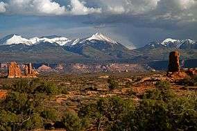
La Sal Mountains as seen from Arches National Park | |
 | |
| Location | Mesa and Montrose counties, Colorado and Carbon, Emery, Grand, San Juan, Sanpete, and Sevier counties, Utah, U.S. |
| Nearest city | Moab, UT |
| Coordinates | 39°17′00″N 111°25′29″W / 39.2832965°N 111.4246294°WCoordinates: 39°17′00″N 111°25′29″W / 39.2832965°N 111.4246294°W[1] |
| Area | 1,270,886 acres (5,143.09 km2)[2] |
| Established |
Manti-La Sal: August 28, 1950; Manti: May 29, 1903; La Sal: January 25, 1906[3] |
| Visitors | 900,000 (in 2006)[4] |
| Governing body | U.S. Forest Service |
| Website | Manti-La Sal National Forest |
The Manti-La Sal National Forest covers more than 1.2 million acres (4,900 km2)[2] and is located in the central and southeastern parts of the U.S. state of Utah and the extreme western part of Colorado. The forest is divided into three districts: the La Sal District at Moab in the La Sal Range near Moab, in the La Sal District at Monticello in the Abajo Mountains west of Monticello, and the Manti Division on the Wasatch Plateau west of Price.[5] The maximum elevation is Mount Peale in the La Sal Mountains, reaching 12,721 feet (3,877 m) above sea level. The La Sal's are the second highest mountain range in Utah after the Uintas.

Location and history
The La Sal Mountain loop road leads from Castle Valley to Geyser Pass and back down to Moab. Scenic Oowah Lake can be found within the forest.
In descending order of land area, the forest is located in parts of San Juan, Sanpete, Emery, Utah, Grand, Carbon, and Sevier counties in Utah, as well as Montrose, and Mesa counties in Colorado (Only about 2.1% of the forest lies in Colorado). Forest headquarters is located in Price, Utah. District offices are located in Ephraim, Ferron, Moab, Monticello, and Price.[6]
The forest was originally established as the Manti Forest Reserve by the General Land Office on May 29, 1903 with 584,640 acres (2,366.0 km2). On July 1, 1915 Nebo National Forest was added, and La Sal National Forest on November 11, 1949. On August 28, 1950 the name became Manti-La Sal National Forest.[7]
Recreation
Manti La Sal National Forest is very popular for recreation. The northern district on the Wasatch Plateau is well known for the Skyline Drive, an unpaved road tracing along the backbone of the plateau. There is also an extensive ATV trail system in the forest there. The Moab District in the La Sal Mountains contains excellent hiking, as well as spectacular views over the desert regions of Canyonlands National Park and Arches National Park. The Monticello District is home the Manti La Sal National Forest's only wilderness area, the Dark Canyon Wilderness, a vast, remote canyon area.[8]

See also
References
- ↑ "Manti-La Sal National Forest". Geographic Names Information System. United States Geological Survey. Retrieved January 24, 2013.
- 1 2 "Land Areas of the National Forest System" (PDF). U.S. Forest Service. January 2012. Retrieved June 30, 2012.
- ↑ "The National Forests of the United States" (PDF). ForestHistory.org. Retrieved July 30, 2012.
- ↑ Staff (April 2010). "Utah Forest Highway Long Range Transportation Plan" (PDF). Central Federal Lands Highway Division. Retrieved 27 May 2012.
- ↑ "Welcome to the Manti-La Sal National Forest". U.S. Forest Service.
- ↑ "USFS Ranger Districts by State" (PDF). U.S. Forest Service. Retrieved January 24, 2013.
- ↑ Davis, Richard C. (September 29, 2005), National Forests of the United States (pdf), The Forest History Society
- ↑ "Manti-La Sal National Forest". Utah.com. Retrieved January 24, 2013.
External links
| Wikimedia Commons has media related to Manti-La Sal National Forest. |